Forecast for the Moab Area Mountains

Eric Trenbeath
Issued by Eric Trenbeath for
Sunday, December 16, 2018
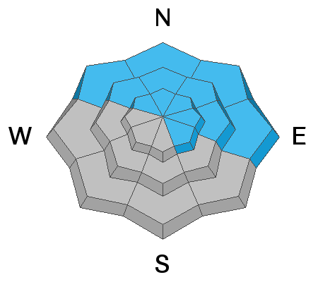
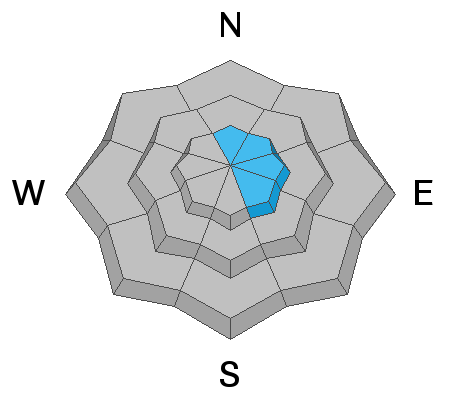
The avalanche danger is MODERATE on mid and upper elevation steep slopes that face NW-N-E, and human triggered avalanches breaking down into buried, persistent weak layers are still possible in these areas. Steep, rocky terrain that has a weak shallow snowpack is the most suspect. On upper elevation slopes facing primarily N-E-SE there is a MODERATE danger for triggering a stiff slab of wind drifted snow. Avoid slopes with a smooth, rounded appearance or that sound hollow like a drum. Most other terrain has generally LOW danger.
Low
Moderate
Considerable
High
Extreme
Learn how to read the forecast here
Special Announcements
Check out the new free online avalanche course series developed by the Utah Avalanche Center. This is a great way to refresh your skills or prepare you for a Backcountry 101 or Level 1 class.
Thanks to Grand County Search and Rescue, Classic Air Medical, and instructors Scott Solle, Chris Benson, and Tim Mathews for making yesterday's winter training a success!
Weather and Snow
Skies are clear, WSW winds are calm to non-existent, and temps are in the high 20's. I'm sure we'd all prefer snow but it's going to be a beautiful day in the mountains. Look for continued sunny skies, mostly calm SW winds with 10,000' temps in the upper 30's. We'll see a few clouds on Monday as a weak disturbance clips by to the north with a return to high pressure later in the week.
Wednesday's wind event put the final hurt on exposed snow surfaces and you'll have to work hard to find soft snow in sheltered locations. Low snow conditions still prevail as well with rocks and deadfall lurking just beneath the surface so be careful out there. Base depth in Gold Basin is 30".
Chris Benson was out flying around on Wednesday, and sent in this aerial observation. Not much has changed since then and the aerial view gives a great overall perspective on current conditions.
A view of the North Group looking south. Chris Benson photo.
New snow totals in Gold Basin (10,000')
Snow totals at the Geyser Pass Trailhead (9600')
Wind, temperature, and humidity on Pre Laurel Peak (11,700')
National Weather Service point forecast.
Recent Avalanches
In my travels Thursday I observed a few natural avalanches from the previous day's WNW wind event. Initiating from wind drifted snow, they appeared to have broken down into old weak layers with fractures 2'-3' deep, and up to 50' wide. These all occurred on E-NE facing slopes in the highest elevations.
Ad
Avalanche Problem #1
Persistent Weak Layer
Type
Location
Likelihood
Size
Description
Time and warm temperatures have helped to stabilize the snowpack, but persistent weak layers of loose, sugary, faceted snow remain. A melt freeze crust of varying strength and thickness exists on top of the October snow, and loose facets have developed above it and below. In areas where the snowpack is shallow, faceted snow beneath the crust exists all the way to the ground. In areas where the snowpack is more than about 3' deep, these weak layers are gaining strength. Spatial variability, or the variability in snow cover, is a key element right now. All you need to do is find the right trigger point in a rocky, shallow area, or above a hidden bush, and you could still trigger a dangerous avalanche 2'-4' deep.
Avalanche Problem #2
Wind Drifted Snow
Type
Location
Likelihood
Size
Description
Wednesday's wind event created stiff slabs of wind drifted snow in the upper elevations, primarily on slopes with an easterly component. They'll be stubborn today, but a triggered wind slab has the potential to break down into buried, persistent weak layers causing a deep and dangerous avalanche. Avoid steep slopes and areas such as cross-loaded gullies that have a smooth rounded appearance, or where the snow feels hollow underneath.
Additional Information
Volunteers from LUNA have been out grooming regularly and there is plenty of snow for Nordic skiing. With the current overall snow conditions, and warm sunny weather, this could be the best game in town for winter mountain enthusiasts!