Forecast for the Moab Area Mountains

Dave Garcia
Issued by Dave Garcia for
Saturday, November 19, 2022
Mostly benign avalanche conditions exist and the snowpack is mostly stable. It may still be possible to trigger a small slab of wind drifted snow, or a loose, dry sluff in isolated areas or in more extreme terrain.
It's still low tide out there and rocks, stumps, and deadfall are lurking just beneath the surface. A ride in even a small avalanche in these low snow conditions would be rugged.
Low
Moderate
Considerable
High
Extreme
Learn how to read the forecast here
Special Announcements
We've not yet begun issuing regular daily avalanche forecasts but will update this page as conditions warrant. Also follow us on Instagram @utavy_moab
Join us for the 1st Annual UAC Moab/LUNA Winter Kickoff Party on 12/10 at the MARC. The event will be from 7-9 PM. Get your tickets here.
Road Conditions: Grand County has not yet begun plowing the road to Geyser Pass Trailhead. The road is hard-packed snow and slick in places. Good tires and all wheel drive are recommended.
Weather and Snow
Cold and dry conditions exist throughout the extended period.
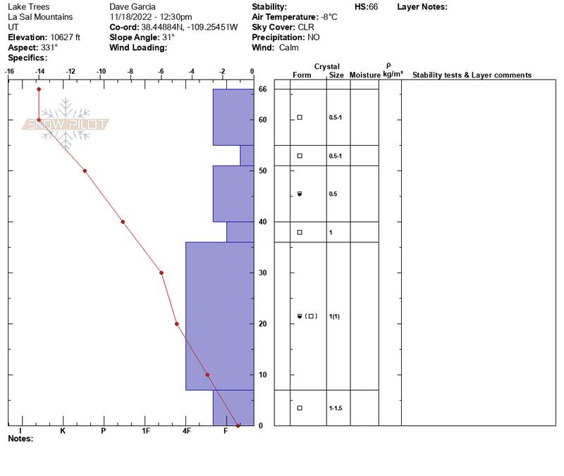
The snow surface consists of a mixed bag of sun crusts, wind crusts, old stubborn wind slabs, and cold loose snow. The snowpack on northerly-facing slopes is cold, weak, and shallow. A strong temperature gradient exists in our shallow snowpack. On these aspects, facets have developed in every layer of the pack. The extended forecast shows cold clear conditions and this will continue the faceting process. What does this mean? For now conditions are mostly stable, but we are developing future weak layers. In the meantime, your greatest danger comes from traveling in low snow conditions. Average depth is around 18" at 10,000' and rocks, stumps, and other obstacles are barely covered up. It may still be possible to trigger a small slab of wind-drifted snow or a loose, dry sluff in isolated areas or in more extreme terrain. A ride in even a small avalanche in these low snow conditions would be rugged.
This snow profile from Friday 11/18 details a cold, weak snowpack on a northerly aspect.
If you are getting up into the mountains please submit an observation and let us know what you are seeing!
Get the most recent observations here.
Get current and past 24-hour readings from these real-time weather links:
Snow and Snow Water Equivalent (SWE) at the Gold Basin SNOTEL site (10,000')
Snow and Snow Water Equivalent (SWE) near the Geyser Pass Winter Trailhead (9600')
Wind Speed and Direction on Pre-Laurel Peak (11,400')
NWS point forecast for the La Sal Mountains.
It's still low tide and rocks and logs are a real hazard.
Ad
Additional Information
Even if you're not planning to get onto the snow, it's never too early to start thinking about avalanches. A few things to consider doing:
  • Sign up for an avalanche class.
  • Take the all-new online avalanche courses the UAC built for Know Before You Go or take other online courses listed on the KBYG website (Develop skills -> Online Learning).
  • Get your avalanche rescue gear ready for winter. Put fresh batteries in your transceiver and update the firmware. Inspect your shovel and probe. Get your airbag backpack ready by possibly doing a test deployment and update the firmware if it is an electric version.
This forecast is from the U.S.D.A. Forest Service, which is solely responsible for its content. This forecast describes general avalanche conditions and local variations always occur.
General Announcements
This forecast is from the U.S.D.A. Forest Service, which is solely responsible for its content. This forecast describes general avalanche conditions and local variations always occur.