UDOT PLANNED AVALANCHE CLOSURES!!

Forecast for the Moab Area Mountains

Eric Trenbeath
Issued by Eric Trenbeath for
Wednesday, January 9, 2019
Heads up! It's dangerous out there and avalanche conditions are the touchiest I've seen in years. The avalanche danger is CONSIDERABLE - new snow, and wind drifted snow have dangerously overloaded a weak snowpack, and human triggered avalanches on steep slopes facing W-N-E are likely if not certain. At upper elevations, a high likelihood for human triggered avalanches may also exist on SE facing aspects. Backcountry travelers need to possess excellent route finding skills and know how to avoid steep, avalanche prone terrain - this includes not usually recognized areas such as gullys, steep banks, or the toes of moraines. Slopes do not need to be that tall to bury you.
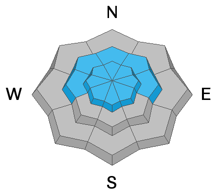
Low
Moderate
Considerable
High
Extreme
Learn how to read the forecast here
Special Announcements
We will be offering a Backcountry 101 avalanche course on Feb 8, 9. It's a great way to up your avalanche knowledge with both classroom, and hands on field instruction. Click here for more details and to register.
The new UAC IOS mobile app is now available on the app store. Check out the new "My Weather" feature.
Check out the new free online avalanche course series developed by the Utah Avalanche Center. This is a great way to refresh your skills or prepare you for a Backcountry 101 or Level 1 class.
Weather and Snow
Southeasterly winds picked up around 9:00 p.m. last night and have been averaging 25 mph with gusts into the 40's. Mountain temps are currently in the mid 20's. Today look for mostly sunny skies with a few high clouds, breezy SW winds, and temps at 10,000' around 30 degrees. A weak disturbance will bring clouds to the area on Thu-Fri with dry conditions through the weekend.
Sunday's storm brought 12" of dense snow to the mountains, accompanied by strong SW winds. Snow conditions are definitely "upside down" with lower density snow underneath the most recent snow. Conditions are soft in sheltered areas but a bit tricky due to the inverted nature. A strong sun yesterday moistened southerly aspects so expect to find them crusted over today. The new snow has greatly improved coverage and we now have a 40" base in Gold Basin.
Avalanche conditions are the touchiest I've seen in years and it's definitely "hair trigger" out there right now. Check out the video below for a full report.
Lots of great observations came in this week, See the list here.
New snow totals in Gold Basin (10,000')
Snow totals at the Geyser Pass Trailhead (9600')
Wind, temperature, and humidity on Pre Laurel Peak (11,700')
National Weather Service point forecast.
Recent Avalanches
Lots of recent avalanche activity was noted in the backcountry yesterday, and I'll be working to update the data base. Brian Hays detailed this slide. And then there was this avalanched road cut, a very in your face example of current conditions.
Ad
Avalanche Problem #1
Persistent Weak Layer
Type
Location
Likelihood
Size
Description
New snow and wind drifted snow have dangerously overloaded a weak snowpack, and human triggered avalanches stepping down into buried persistent weak layers of loose, sugary, faceted snow are likely, if not certain. These weak layers are found primarily on slopes facing the north half of the compass but the problem may wrap around further to the W and SE. Now is the time to avoid steep, avalanche prone terrain. The video below illustrates how a persistent weak layer on a NE aspect is reacting to the new snow load.
Avalanche Problem #2
Wind Drifted Snow
Type
Location
Likelihood
Size
Description
Southerly winds will be blowing and drifting snow. In addition, strong SW winds accompanied the storm, and deep drifts of unstable snow have formed in many locations. Above treeline you may find drifts on all aspects on the lee sides of ridge crests and terrain features. Below treeline, most of the drifting will be on slopes with a northerly aspect. Avoid any stope slope that you suspect may be wind loaded - look for telltale signs such as a smooth rounded appearance, or cracking in the snow surface.
Additional Information
Trails were groomed yesterday and cross country skiing offers a safe alternative for visiting the mountains!
General Announcements
Your information can save lives. If you see anything we should know about, please help us out by submitting snow and avalanche observations HERE. You can also call me at 801-647-8896, or send me an email: [email protected].
Support the UAC through your daily shopping. When you shop at Smith's, or online at REI, Backcountry.com, Patagonia, NRS, Amazon, eBay by clicking on these links, they donate a portion of your purchase to the UAC. If you sell on eBay, you can have your See our Affiliate Page for more details on how you can support the UAC when you shop
This advisory is from the U.S.D.A. Forest Service, which is solely responsible for its content. This advisory describes general avalanche conditions and local variations always occur.