Forecast for the Moab Area Mountains

Eric Trenbeath
Issued by Eric Trenbeath for
Monday, January 7, 2019
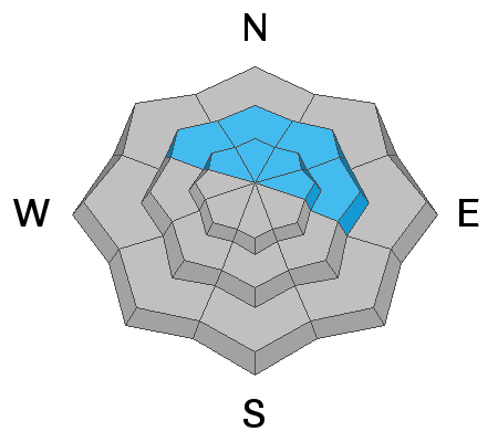
Areas of HIGH danger exist at upper elevations on slopes that face N-NE-E where wind drifted snow has dangerously overloaded the snowpack. The avalanche danger is CONSIDERABLE today on all other aspects at upper and mid elevations where human triggered avalanches involving a slab of dense, new snow are likely. Backcountry travelers need to have excellent route finding skills and know how to stay off of and out from under steep slopes today. Stick to low angle, sheltered terrain and meadows that aren't threatened from above.
Low
Moderate
Considerable
High
Extreme
Learn how to read the forecast here
Special Announcements
Grand County will be up plowing today, expect to find the gate locked by 9:00.
We will be offering a Backcountry 101 avalanche course on Feb 8, 9. It's a great way to up your avalanche knowledge with both classroom, and hands on field instruction. Click here for more details and to register.
The new UAC IOS mobile app is now available on the app store. Check out the new "My Weather" feature.
Check out the new free online avalanche course series developed by the Utah Avalanche Center. This is a great way to refresh your skills or prepare you for a Backcountry 101 or Level 1 class.
Weather and Snow
A good storm yesterday delivered a foot of dense snow to the mountains. Moderate to strong SSW winds blew most of the day at upper elevations, and occasionally gusting below treeline. Today look for mostly cloudy skies and a chance for snow showers. SW winds will blow in the 15-25 mph range with gusts into the 30's along ridge tops. High temps will be in the low 20's.
Dangerous conditions exist and you will want to be on your game out there today if you want to enjoy the new snow. Fortunately, the new snow is quite dense and fast, and you can easily have a good time on low angle, wind sheltered terrain.
Charlie Ramser was out yesterday and sent in this observation.
New snow totals in Gold Basin (10,000')
Snow totals at the Geyser Pass Trailhead (9600')
Wind, temperature, and humidity on Pre Laurel Peak (11,700')
National Weather Service point forecast.
Ad
Avalanche Problem #1
New Snow
Type
Location
Likelihood
Size
Description
Yesterday's storm snow formed a dense, cohesive slab on all aspects and my partners and I experienced widespread collapsing, and cracking in the snow surface. I expect the slab will continue to be reactive today with human triggered avalanches likely. Backcountry travelers are advised to avoid slopes steeper than about 30 degrees on all aspects.
Avalanche Problem #2
Wind Drifted Snow
Type
Location
Likelihood
Size
Description
Lots of blowing and drifting of snow occurred throughout the day yesterday, and southwesterly winds today will continue to move snow around. Recent, deep drifts will be most prevalent above treeline on slopes facing NW-NE-E, but some drifting has occurred at mid and lower elevations. Basically, the same rule as in avalanche problem number one applies - avoid steep terrain, and stay out from under the big northerly facing slopes where natural wind slab releases are possible.
Avalanche Problem #3
Persistent Weak Layer
Type
Location
Likelihood
Size
Description
The dense new snow, combined with wind has dangerously overloaded our fragile snowpack re-activating buried persistent weak layers. Stability tests produced easy failures on a buried layer of near surface facets, but it may also be possible to trigger an avalanche 2'-4' deep on weak, sugary, faceted snow near the ground.
General Announcements
Your information can save lives. If you see anything we should know about, please help us out by submitting snow and avalanche observations HERE. You can also call me at 801-647-8896, or send me an email: [email protected].
Support the UAC through your daily shopping. When you shop at Smith's, or online at REI, Backcountry.com, Patagonia, NRS, Amazon, eBay by clicking on these links, they donate a portion of your purchase to the UAC. If you sell on eBay, you can have your See our Affiliate Page for more details on how you can support the UAC when you shop
This advisory is from the U.S.D.A. Forest Service, which is solely responsible for its content. This advisory describes general avalanche conditions and local variations always occur.