Sign Up for the Utah Snow and Avalanche Workshop (USAW) on December 7th!

Forecast for the Moab Area Mountains

Eric Trenbeath
Issued by Eric Trenbeath on
Sunday morning, January 2, 2022
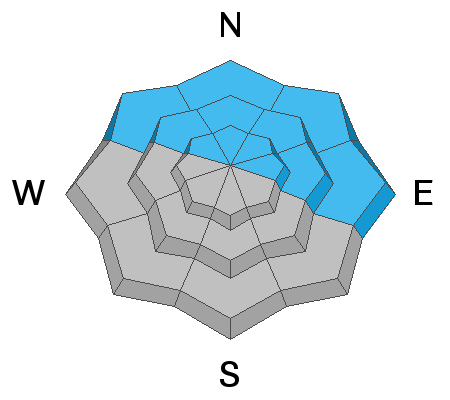
The avalanche danger remains HIGH on steep, wind drifted slopes above treeline that face NW through E and deep and dangerous, human triggered avalanches 3'-5' deep are likely in these areas.
The avalanche danger is CONSIDERABLE on all aspects near and above treeline where you can detect recent deposits of wind drifted snow.
With fresh powder, sunny skies, and warming temperatures, conditions are ripe for an avalanche accident. Backcountry travelers need to temper their enthusiasm and have excellent route finding skills. Stick to low angle wind sheltererd terrain and avoid slopes steeper than 30 degrees.
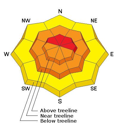
Low
Moderate
Considerable
High
Extreme
Learn how to read the forecast here
Special Announcements
Road Conditions: Deep and drifting snow have made the road to Geyser Pass trailhead largely impassable.
Grooming: Grooming will be temporarily on hold with so much new snow and a downed trees that need to be cleared.
Folks yesterday were parking cars at the bottom of the Geyser Pass Road and getting up to wherever they could. A few folks made it to the trailhead and above.
Weather and Snow
24 Hour Snow 0" 72 Hour Snow 22" Base Depth in Gold Basin 51" Wind NW 15-25 Temp 3F
Gold Basin SNOTEL site (10,000')
Storm Totals in Gold Basin
Wind Station on Pre Laurel Peak (11,700')
NWS Weather Forecast
Overnight NW winds continued to blow in the 15-25 mph range along ridge tops. They should decrease today and shift back around to the SW by this afternoon. A ridge of high pressure is building over the region and pushing the storm track north. We'll see sunny skies today through Monday with gradually warming temperatures. Clouds develop Monday night as a shortwave disturbance brings a chance for snow to points north. Down here in the south, we'll should stay dry through the week with the next chance for snow looking like next weekend.
Snowpack
As you all know by now, we just got a nice dump with up to 2' of new snow at 2.5" Snow Water Equivalent (SWE) in a span of a little more than 12 hours on Friday. Moderate to strong SW winds blew during the duration of the storm and deep drifts formed on northerly aspects at all elevations. This has placed a significant load on slopes that had a pre-existing slab on top of persistent weak layer of of sugary, faceted snow. It's going to take us a little time to determine the effects of this load on the persistent weak layer, and for now I'm going to assume that deep and dangerous, human triggered avalanches remain likely on steep slopes at mid and upper elevations that face NW through E.
Chris Benson made it up the Laurel Ridge yesterday, and he observed active wind loading from the NW winds with fresh drifts and new wind slabs forming on all aspects above treeline. He also observed a couple of natural avalanches listed below. He said the relatively dense storm snow "was skiing fast and was still soft below treeline." Read his observation here.
Looking good!
Recent Avalanches
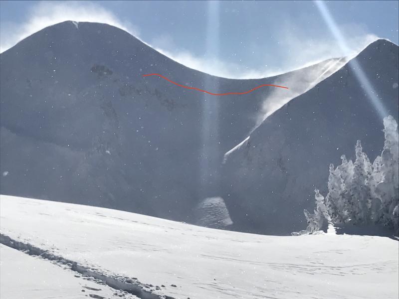
Chris Benson was up on Laurel Ridge yesterday where he noted this natural avalanche in Red Snow Cirque, and this one in Exxon's Folley. It's difficult to say if these slides failed on the old, October, facted weak layer, but the overall depths seen from a distance made it appear as such.
Avalanche in Red Snow Cirque taken on January 1, 2022. Note active windloading. Chris Benson photo.
Ad
Avalanche Problem #1
Persistent Weak Layer
Type
Location
Likelihood
Size
Description
A heavy load of recent, new, and wind drifted snow has been added to a pre-existing slab on top of a persistent weak layer of loose, sugary, faceted snow at the base of the snowpack. We'll need some time and visibility to see how this load has affected this weak layer so for now, I'm going to assume that deep, dangerous, and un-survivable human triggered avalanches are likely on steep slopes facing NW through E. The danger increases with elevation.
Avalanche Problem #2
Wind Drifted Snow
Type
Location
Likelihood
Size
Description
Shifting wind directions have blown and drifted snow on to all aspects near and above treeline. Today, be on the lookout for sensitive new wind drifts to be lurking just about everywhere in wind exposed terrain. Wind slabs form on leeward slopes just below ridge crests. They can also be found on the leeward sides of terrain features such as sub ridges, gully walls, and rock outcroppings. Fresh drifts are recognizable by their smooth, rounded appearance, and cracking is a sign of instability. On northerly aspects, wind drifted snow has added stress to older slabs on top of a buried persistent weak layer and dangerous, human triggered avalanches 3'-5' deep are possible. Avoid steep, wind drifted slopes.
General Announcements
Who's up for some free avalanche training? Get a refresher, become better prepared for an upcoming avalanche class, or just boost your skills. Go to https://learn.kbyg.org/ and scroll down to Step 2 for a series of interactive online avalanche courses produced by the UAC.
This forecast is from the U.S. Forest Service, which is solely responsible for its content. This forecast describes general avalanche conditions and local variations always occur.