Join us at our 2nd Annual Blizzard Ball

Forecast for the Moab Area Mountains

Nikki Champion
Issued by Nikki Champion on
Sunday morning, January 19, 2025
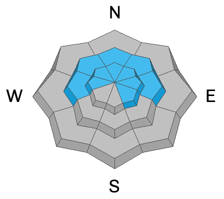
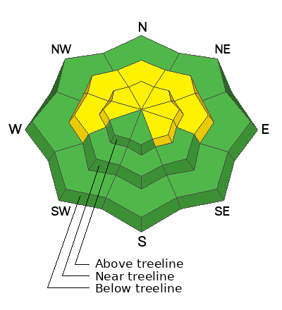
A MODERATE avalanche danger exists on W-N-E-SE aspects near and above treeline, where slabs of wind-drifted snow rest atop a buried persistent weak layer. The most suspect terrain is on steep W-N-E facing slopes near treeline, where human-triggered avalanches 1-2 feet deep remain possible.
Above treeline, there is a low-probability but high-consequence risk for full-depth avalanches failing on weak facets near the ground in isolated areas. This risk is decreasing, but to mitigate it, avoid thin slopes, steep convexities, and rocky, extreme terrain on northerly aspects.
Most other terrain has a LOW danger, though small avalanches involving thin slabs of wind-drifted snow may still occur on isolated features.
Low
Moderate
Considerable
High
Extreme
Learn how to read the forecast here
Special Announcements
Geyser Pass Road: Surface is mainly snowpacked and icy. AWD with good tires required.
Grooming Conditions: Gold Basin through Geyser Pass was groomed yesterday.
The beacon park is up and running. High pressure is a great time to work on your beacon skills.
Weather and Snow
6 A.M. Snow and Weather Data
24 Hour Snow: 1" 72 Hour Snow: 1" Season Total Snow: 61" Depth at Gold Basin: 30"
Winds on Pre-Laurel Peak: NW 15-20 Temp: -5° F Percent of Normal (SWE): 90%
Weather
This morning, skies remain broken, and overnight temperatures plummeted, ranging from -3°F to -7°F on ridgelines. Winds were west-northwesterly around 6 a.m., averaging 15-20 mph, with gusts up to 30 mph. Yesterday, the mountains picked up a trace of snow, with about an inch of new accumulation in favored zones.
Today, temperatures will remain cold, with highs staying well below 10°F. Northwesterly winds will average 10-15 mph, with gusts up to 30 mph. There is a slight chance of additional snowfall this evening, primarily after 5 p.m.
The cold air will persist into early next week.
General Conditions
The trace amount of snow yesterday marked a welcome pattern shift, even if it didn’t significantly change riding conditions—it was just good to see snowflakes fly. Soft snow can still be found, but it’s hit or miss. Your best chances are on sheltered, northerly aspects below treeline.
While avalanche risk is decreasing, a weak, faceted layer about a foot below the surface remains a concern. You can easily identify it with a shovel, and if you find a slab above this layer, it’s best to avoid steep slopes (see more below).
Along ridgelines, elevated winds from the 15th have stripped and scoured the surface, making travel more complex than it was a few days ago. Additionally, many slopes have thin snow cover, with rocks, stumps, and logs just beneath the surface. Don’t end your season before it even begins!
Snowpack and Weather Data
Gold Basin SNOTEL site (10,000')
SNOTEL site near Geyser Pass Winter Trailhead (9600')
Wind Station on Pre-Laurel Peak (11,400')
NWS forecast for the La Sal Mountains.
Recent Avalanches
No new avalanches were reported from the backcountry yesterday. On Friday, Dave and I observed natural, shallow wind slabs in the Talking Mountain Cirque, primarily on northeast aspects near 11,000’ and true north aspects around 10,800’. These likely occured during the 1/15 wind event in the same areas as the 12/27 avalanche cycle.
See the avalanche database here.
Ad
Avalanche Problem #1
Persistent Weak Layer
Type
Location
Likelihood
Size
Description
The primary avalanche problem is a weak layer of faceted snow from the December dry spell, buried on 12/25, about a foot below the surface on W-N-E-SE aspects. While the weak layer is widespread, the overlying slab is not—and both are needed to create an avalanche.
Westerly, northerly, and easterly aspects near treeline are most concerning, where cohesive slabs 1-2 feet deep are more consistent. You may transition from soft, weak snow or scoured terrain to standing atop a supportable slab resting on weak facets. Be cautious in gullies, depressions, and leeward terrain features, where slabs are more likely to form. Avalanches triggered 1-2 feet deep could step down to basal facets near the ground.
Above treeline, the likelihood of triggering an avalanche continues to decrease. Strong northerly winds have stripped snow from many aspects, leaving behind a stout wind crust that caps the weak layer on other aspects. This, combined with mid-pack and basal facets trending toward dormancy, reduces avalanche risk. However, thin, rocky slopes with shallow snowpacks above treeline should still be avoided.
Additional Information
Sign up for text alerts to get the most up to date information about changing conditions, road plowing, special avalanche announcements.
Follow us on Instagram @utavy_moab
General Announcements
This forecast is from the U.S.D.A. Forest Service, which is solely responsible for its content. This forecast describes general avalanche conditions and local variations always occur.