Forecast for the Moab Area Mountains

Eric Trenbeath
Issued by Eric Trenbeath on
Tuesday morning, January 12, 2021
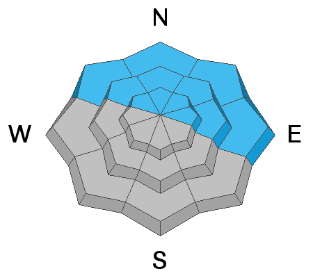
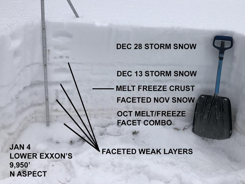
Human triggered avalanches remain likely on steep, northerly facing slopes that have enough snow to ski or ride. However, due to a lack of sufficient snow cover on the majority of the terrain, the avalanche danger is isolated to specific features and therefore MODERATE. With the current snowpack structure consisting of a slab on top of layers of weak, sugary, faceted snow, steep, NW-E facing slopes with sufficient cover should be avoided for the foreseeable future. Most south-facing terrain has generally LOW danger.
Low
Moderate
Considerable
High
Extreme
Learn how to read the forecast here
Special Announcements
The Geyser Pass Road is plowed. The surface is snow packed on dirt.
The Lower Utah Nordic Alliance (LUNA) groomed all trails on Saturday.
Chris Benson has detailed the last two weeks in this excellent synopsis.
Tonight: Please join UAC Forecaster Craig Gordon in partnership with Park City Professional Ski Patrol Association on a Zoom presentation from 6:30-7:30 as we discuss the current state of our snowpack, what we can expect moving forward, and how we can still ride the Greatest Snow on Earth safely. Go here for zoom link.
I'm very sorry to report Utah's first avalanche fatality of the season. A 31-year-old man was killed in a backcountry area in the Wasatch Mountains know as Dutch Draw. Our sincere condolences go out to the family and friends. Here is the final report.
Weather and Snow
Under the current extended dry pattern, I won't be doing daily weather updates. Use the weather links below for the forecast and current conditions.
Wind, temperature, humidity on Pre Laurel Peak (11,700')
Snotel site near Geyser Pass Trailhead (9600')
Storm totals at the Gold Basin study plot (10,000')
Snowpack Discussion In our travels to the east side of the range on Sunday, pro observer Nate Ament and I continued to observe signs of instability such as cracking and collapsing. We also observed a general deterioration of the shallow snowpack. Below treeline, the entire snowpack is starting to lose cohesion with the overriding slab beginning to disintegrate as well. Near treeline, the overriding slab is stiffer and more sensitive. Above treeline, the snow in many areas has been ravaged by the wind, and scoured surfaces alternate with smooth, hard slabs and crusts. Conditions are deceiving due to the overall lack of coverage and the general inaccessibility of avalanche terrain, but if you went searching for an avalanche you could still most certainly find one. Pro observer Dave Garcia sums it up like this, "if I attempted to ski anything that has enough snow to actually make turns I would most likely trigger an avalanche." The video below illustrates the current conditions.
Ad
Avalanche Problem #1
Persistent Weak Layer
Type
Location
Likelihood
Size
Description
Our snowpack is rife with persistent weak layers of loose, sugary, faceted snow along with a couple of smooth, hard, melt feeze layers to form a perfect bed surface. Red flag signs of instability such as collapsing and whumphing continue to be oberved. Although avalanche terrain remains difficult to access due to low coverage, human-triggered avalanches are likely steep, northerly facing slopes that have sufficient snow cover.
This snowpit illustrates the precarious state of the snowpack.
General Announcements
This forecast is from the U.S. Forest Service, which is solely responsible for its content. This forecast describes general avalanche conditions and local variations always occur.