Donate to the 2024 Spring Campaign to help rebuild the UAC website.

Forecast for the Logan Area Mountains

Toby Weed
Issued by Toby Weed for
Saturday, April 6, 2019
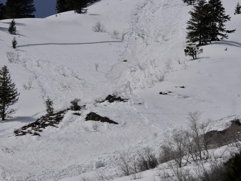
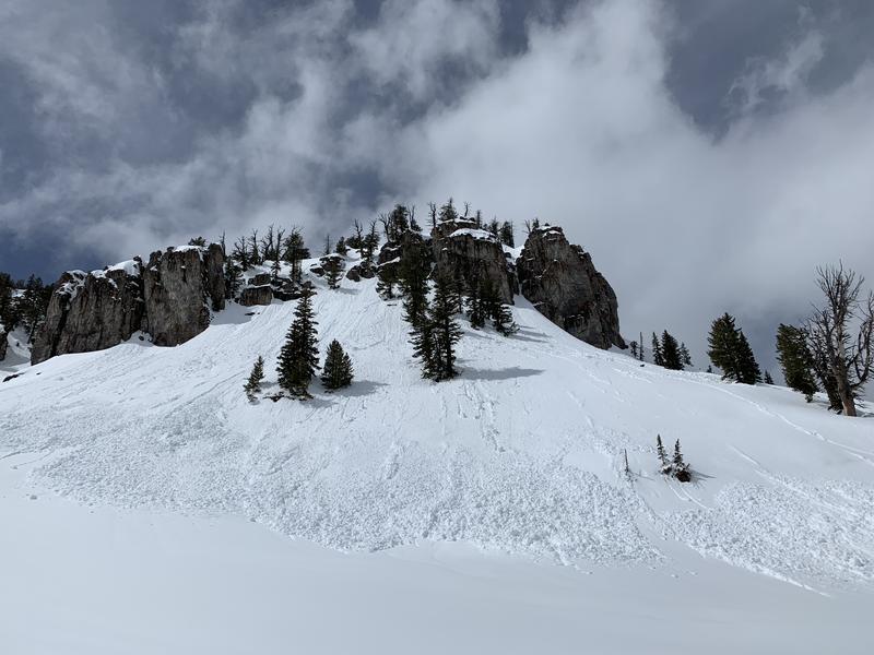
CONSIDERABLE: Rain falling on saturated snow overnight created dangerous avalanche conditions at lower elevations. Destructive natural activity is possible, and it is likely people will trigger avalanches of wet snow. Warm daytime temperatures will cause heightened wet avalanche conditions at all elevations, and avalanches entraining several inches of last night's sodden fresh snow could produce sizable piles of cement-like debris. Avalanches failing on a buried persistent weak layer of surface hoar remain possible on isolated northerly facing slopes at upper elevations.
Use extra caution in the backcountry today. Evaluate snow and terrain carefully, and make conservative decisions.
Low
Moderate
Considerable
High
Extreme
Learn how to read the forecast here
Special Announcements
When the forecasting ends, the UAC’s work keeps going strong. Summer is a busy time for the UAC. During the summer we are working hard on our fall and winter planning; putting together the Fall Fundraiser and USAW; updating our awareness and education programs; this summer we will be finishing up the website redesign project. Your donation shows you’re invested in this community all year round! You can still be part of the UAC’s success in 2019. Consider making a donation by April 8.
Weather and Snow
The Tony Grove Snotel at 8400' reports 4 inches of new snow overnight, with .4" SWE. Temperatures are hovering right around freezing, currently 31ºF this morning, and there is 84"of total snow. I'm reading 25ºF at the 9700' CSI Logan Peak weather station, and west-northwest winds are averaging around 17 mph. Rain on the soft and saturated snow overnight created dangerous avalanche conditions at lower elevations. Temperatures will climb to near 40ºF at upper elevations today, the sun might pop out this afternoon, and heightened wet avalanche conditions will develop at all elevations.

A storm system will continue east across Utah this morning. High pressure aloft will return to start the week before a much stronger and colder storm system arrives mid-week. We'll see snow showers continuing in the mountains this morning, with 1 to 2 inches possible. High temperatures at 8500' are expected to be around 40ºF, with 11 to 17 mph north-northwest wind. It will be partly cloudy tonight, with low temperatures around 25 ºF , and 13 to 15 mph west winds. Snow showers are expected tomorrow, with an inch or so possible. It will be mostly cloudy and warm. High temperatures are expected to be near 43ºF, with 16 to 20 mph west-southwest winds.
Recent Avalanches
Numerous fairly large natural wet loose and a few wet slab avalanches occurred in the past few days across the Logan Zone. Wet loose avalanches, entraining recent storm snow occurred with solar warming, mostly on Wednesday, although a few probably ran during the heat of the day Thursday and Friday.
A natural wet loose avalanche overrunning a steep mid elevation slope, triggered a wet slab avalanche and created quite a mess below Mitton Peak in the Wellsville Mountain Wilderness.
Natural wet loose and wet slab avalanches entraining last weekend's snow were widespread in the Bear River and Wellsville Mountain Ranges this week.

On Saturday, 3/30/19, two riders were caught, carried, and partially buried in the Whites Canyon Area just north of the Idaho State Line in the Franklin Basin Area. Luckily, there were no injuries. See report HERE
Ad
Avalanche Problem #1
Wet Snow
Type
Location
Likelihood
Size
Description
Rain on the saturated snow at low elevations last night created dangerous wet avalanche conditions. Temperatures are expected to rise to close to 40ºF at upper elevations, and this will cause the new snow to become saturated and prone to avalanching in many areas. Avoid being on or under steep slopes with warmth-softened, saturated surface snow, and stay out of runout gullies.
Stay off and out from under large ridge top cornices, which are likely to break further back than expected and could trigger avalanches on steep slopes below.
Avalanche Problem #2
Persistent Weak Layer
Type
Location
Likelihood
Size
Description
1' to 2' deep avalanches avalanches failing on a buried persistent weak layer of surface hoar or near surface facets will be possible for people to trigger on isolated upper elevation slopes facing the north half of the compass.
  • Use caution in upper elevation areas where drifts form, like on the lee side of major ridges and in and around terrain features like sub-ridges, gullies, scoops, tree stringers, and cliff bands.
Additional Information
I will update this forecast Monday morning.
General Announcements
The new weather station at the WSU Bloomington Canyon Yurt is up and running. Data available HERE
Now is a great time to practice companion rescue techniques with your backcountry partners. You should check out and use the new Avalanche Beacon Training Park we set up at the Franklin Basin trailhead. Special thanks to Northstars Ultimate Outdoors, USU Outdoor Program, and Beaver Mountain Ski Patrol for helping us to make this possible.
The Beaver Mountain Backside is the backcountry, and it is avalanche terrain. Same goes for the steep rocky terrain adjacent to Cherry Peak Resort. If you leave a ski area boundary, you and your partners should carry and practice with avalanche rescue equipment and follow safe backcountry travel protocols.
Check out the improved weather links, road conditions, and weather links for each forecast region on the new UAC IOS App. Do you use the NOAA point forecast? If so, now you can bookmark your favorite weather locations in "My Weather" in the App. HERE
Are you new to the backcountry or looking to refresh your skills? The UAC has released a free 5-part avalanche skills eLearning series. HERE
If you would like to get the daily advisory by email you subscribe HERE.
Support the UAC through your daily shopping. When you shop at Smith's, or online at REI, Backcountry.com, Patagonia, NRS, Amazon, eBay by clicking on these links, they donate a portion of your purchase to the UAC. If you sell on eBay, you can have your See our Affiliate Page for more details on how you can support the UAC when you shop
Remember your information can save lives. If you see anything we should know about, please help us out by submitting snow and avalanche observations. HERE You can call us at 801-524-5304, email by clicking HERE, or include #utavy in your Instagram.
This forecast is from the U.S.D.A. Forest Service, which is solely responsible for its content. The forecast describes general avalanche conditions and local variations always occur.