31st Annual Backcountry Benefit - September 12th - Tickets Available Here!

Forecast for the Logan Area Mountains

Toby Weed
Issued by Toby Weed on
Wednesday morning, April 5, 2023
Dangerous avalanche conditions are found at all elevations on backcountry slopes steeper than 30°.
  • Heavy snowfall has created HIGH danger in drifted upper and mid elevation terrain. Long running natural and human triggered avalanches are likely.
  • A good amount of fresh snow also accumulated on low elevation slopes, and there is CONSIDERABLE danger, with avalanches of new snow likely. Warming in the next few days will elevate the danger of wet avalanches significantly.

People should avoid being in avalanche terrain and stay well clear of avalanche runouts. ***Watch yourselves, children, and animals near structures, since roof avalanches present a real threat.
Low
Moderate
Considerable
High
Extreme
Learn how to read the forecast here
Avalanche Warning
Recent heavy accumulations of snow and drifting have created widespread areas of unstable snow. Long running natural and human triggered avalanches are likely. People should avoid being in backcountry avalanche terrain, (off of and out from under slopes steeper than 30°), and stay clear of avalanche runouts. Be careful near any structures due to potential for roof avalanches.
Special Announcements
We've released the accident report for the 3-27-23 Pole Canyon avalanche in the Oquirrh Mountains .....It's HERE
Weather and Snow
Most people are wisely avoiding avalanche terrain since we are getting SO MUCH SNOW!!! Recent accumulations at lower elevations and in some areas (like the southern part of the zone) are extraordinary. Natural avalanches are possible at all elevations and most likely during periods of very heavy snowfall or increased drifting. Since avalanche starting zones are smoothed in by deep snow and paths are "greased" by previous avalanches, avalanches of new snow can run far and fast. Across the region and with each storm in frequently running paths, avalanches are pushing the historic limits, trimming trees from the edges and running further into the trees than in the past.

It is snowing again this morning at Beaver Mountain. The 8400' Tony Grove Snotel reports 5 inches overnight and 2.5" SWE from the storm. It's 15°F and there is 168" of total snow. The wind is blowing around 15 mph, with gusts around 30 mph at the CSI Logan Peak weather station at 9700'. The Ogden Valley has picked up and amazing amount of snow, with the Ben Lomond Snotel reporting almost 9" SWE in the last week.
Here is the NWS point forecast (36 hrs) for high elevations in the Central Bear River Range:
Today: Snow showers. High near 23. Wind chill values as low as -1. West wind 11 to 18 mph. Chance of precipitation is 80%. Total daytime snow accumulation of 1 to 3 inches possible.
Tonight: A 40 percent chance of snow showers before 9pm. Mostly cloudy, with a low around 4. Wind chill values as low as -11. West wind 10 to 18 mph. New snow accumulation of 1 to 2 inches possible.
Thursday: Sunny, with a high near 31. Wind chill values as low as -5. Southwest wind 8 to 10 mph.
Looks like we'll see some sun on Thursday, and significant warming begins on Friday, with high temperatures near 40°F in the shade on top of Naomi Peak. Upper elevation high temperatures are expected to be over 50° F and it will be sunny on Sunday.
Recent Avalanches
  • Avalanche mitigation efforts at low elevations in Logan Canyon yesterday produced only a couple small avalanches. This probably doesn't give us a great indication of overall conditions though, since significantly more new snow accumulated on the benches in Cache Valley, on the front side, and probably in the Wellsville Range, and in southern part of the zone.
  • We observed numerous instances of snow sliding off roofs in Cache Valley and the surrounding mountains with the seasonal warmth yesterday.
  • An observer reported the party triggered audible collapses, cracking, and observed natural activity in west facing terrain <6000' in elevation in Wood Camp Hollow on Monday. report is HERE
  • Large natural avalanches occurred early Friday morning in the mountains above North Ogden, including off the Ben Lomond Headwall and a handful, crossing and closing the North Ogden Divide road.
  • For a list of recent avalanches in the Logan Zone go HERE
  • There was lots of natural avalanche activity in the mountains of Northern Utah yesterday. Find a list of all recent observations & avalanches from across Utah HERE.
Ad
Avalanche Problem #1
New Snow
Type
Location
Likelihood
Size
Description
  • With several feet of recently fallen new snow, soft slab and loose avalanches of storm snow are possible even in generally sheltered terrain on steep slopes where significant new snow accumulated.
  • Natural avalanches are possible during periods of heavy snowfall or when significant drifting rapidly overloads a slope, but they could be triggered by cornice falls or tree bombs at any time.
    Dangerous conditions are also found at low elevations, especially in steep northerly facing terrain including on shady forested slopes.
  • High angle April sun, possible greenhousing, or rain on the snow could quickly moisten the new snow and rapidly increase potential for wet avalanches.
  • Expect warming temperatures and sun to elevate the danger of wet avalanches significantly in the next few days.
Avalanche Problem #2
Wind Drifted Snow
Type
Location
Likelihood
Size
Description
This morning, winds are blowing moderately from the west-northwest. It was very windy over the weekend, with strong westerly winds. Imagine very dangerous conditions still exist up high, especially in windy terrain, with huge mouse trap sensitive cornices, and thick, freshly formed wind slabs.
  • Large natural cornice falls and 2' to 4' thick soft and harder wind slabs are likely in windy terrain, especially at upper elevations.
  • Avoid corniced slopes and stiffer drifts on steep slopes near ridges and in and around terrain features like cliff bands, sub-ridges, mid-slope break-overs, and gully walls.
  • Evidence of instability could include cracking or collapsing, and some avalanches might be triggered remotely or from a distance.
  • The overhanging cornices on the high ridges are huge this year, and recent storms have built them further out and made them unstable, so people should stay well away and out from under them.
Additional Information

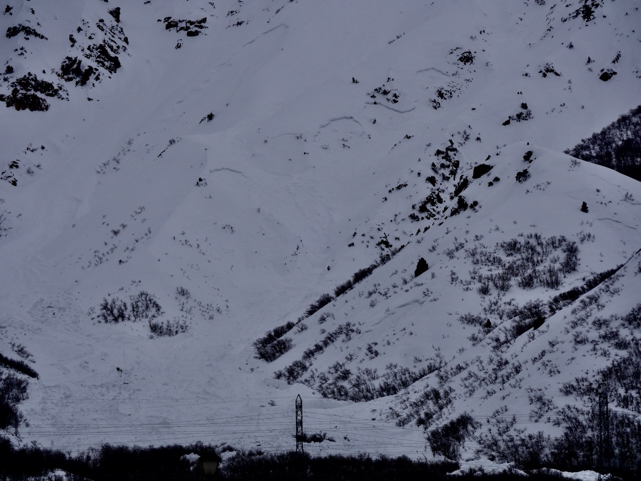
Very large natural avalanches occurred early Friday above Pleasant View and North Ogden, coming off the very steep Ben Lomond Headwall.

General Announcements
  • Please submit your observations from the backcountry HERE.
  • For a list of avalanche classes from the Utah Avalanche Center go HERE
  • For information on where you can ride your sled or snow-bike, check out this map of the winter travel plan for the Logan and Ogden Ranger Districts HERE, and a close up of the Tony Grove and Franklin Basin Areas HERE.
This forecast is from the U.S.D.A. Forest Service, which is solely responsible for its content. This forecast describes general avalanche conditions and local variations always occur.