Forecast for the Logan Area Mountains

Toby Weed
Issued by Toby Weed for
Friday, April 14, 2023
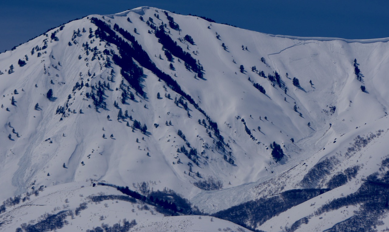
Much colder temperatures last night set up the saturated snow, wet avalanches are unlikely, and the danger is LOW in most terrain. Exceptions and areas with MODERATE danger may exist on some upper elevation slopes where several inches of new snow accumulated and was drifted by westerly winds. People could trigger shallow avalanches of wind drifted snow.
Use normal caution, and evaluate snow and terrain carefully if you venture into upper elevation terrain.
Low
Moderate
Considerable
High
Extreme
Learn how to read the forecast here
Special Announcements
The final UAC report for the Upper Weber Canyon avalanche accident on March 9 has been published and is available HERE. The UAC would like to thank Park City Powder Cats for sharing information about the timeline of the accident and allowing UAC staff access to the avalanche after the incident.
Weather and Snow
Temperatures dropped into the teens overnight at most mountain stations, which has set up and refrozen the saturated snow. Wet avalanches are unlikely and the refrozen snow is generally stable. Several inches of new snow accumulated in parts of the zone, and westerly winds yesterday formed shallow drifts in exposed terrain. Today people could trigger shallow wind slabs and cornice falls on some upper elevation slopes. These will be small, but could be a problem if you are carried into trees or other terrain traps.

The 8400' Tony Grove Snotel reports 17° F and 129" of total snow. It's 12° F and the wind is pretty calm this morning at the Logan Summit UDOT shed.
Here is the NWS point forecast (36 hrs) for Upper Elevations in the Central Bear River Range:
Today: A 30 percent chance of snow showers after noon. Partly sunny, with a high near 31. Light and variable wind becoming west 12 to 17 mph in the morning. Total daytime snow accumulation of less than a half inch possible.
Tonight: A 20 percent chance of snow showers before midnight. Partly cloudy, with a low around 17. Wind chill values as low as 6. West wind 9 to 16 mph.
Saturday: Sunny, with a high near 39. Wind chill values as low as 9. West southwest wind 5 to 10 mph.
Looks like warm temperatures and sun will return Sunday and Monday, with snow showers and cooler temperatures Tuesday and through the work week.
Recent Avalanches
  • Wednesday, ID Hwy 36 was closed due to a canal breach in the Mink Creek area. The resulting flood created a destructive slush avalanche and mudslide which crossed the road and damaged a few structures. HERE
  • Widespread natural wet avalanches occurred earlier this week in the Wellsville Range. Large natural cornice falls and loose avalanches triggered long running and dangerously large wet slabs. I was quite relieved to see no cars parked at the Rattlesnake TH Sunday, after seeing the huge debris pile from a massive natural avalanche that came off the north ridge of Mitton Peak....HERE
A recent large natural avalanche triggered by a cornice fall in the Wellsvilles. Rattlesnake Canyon, N Ridge of Mitton Pk, 4-9-23
  • For a list of recent avalanches in the Logan Zone go HERE.
  • There was tons of recent natural wet avalanche activity in the mountains of Northern Utah. Find a list of all recent observations & avalanches from across Utah go HERE.
Ad
Avalanche Problem #1
Wind Drifted Snow
Type
Location
Likelihood
Size
Description
People could trigger small avalanches of wind drifted snow on upper elevation slopes in areas where several inches of new snow accumulated yesterday.
Avalanche Problem #2
Wet Snow
Type
Location
Likelihood
Size
Description
Wet avalanches are generally unlikely, but may be possible as the snow is softened by seasonal warmth. In some places the saturated snow was insulated by a few inches of new snow and it remains a bit soft and slushy. Low elevation, north facing slopes and forested areas still hold several feet of snow and in some areas it could soften up rapidly due to seasonal warmth.
Additional Information
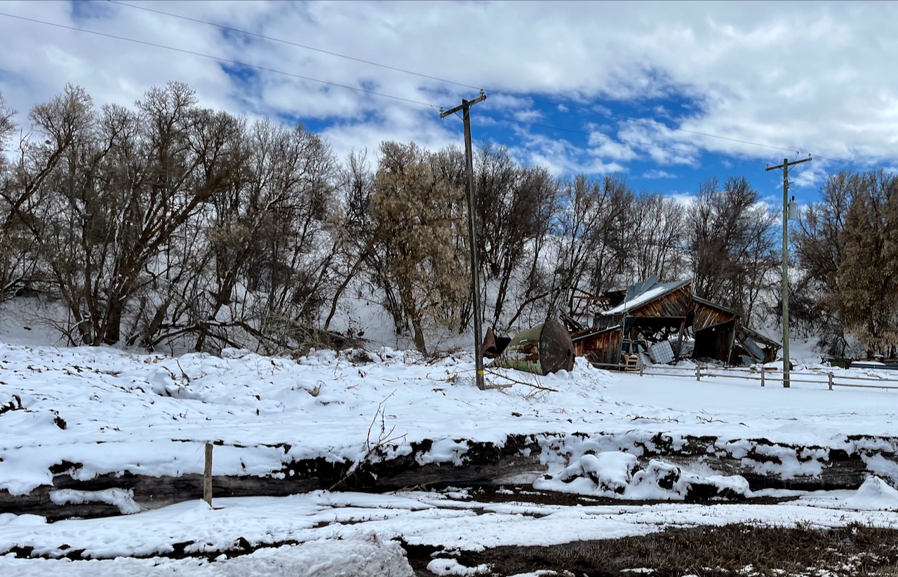
Here's a look at some of the the mess made by a recent canal breach in Mink Creek.
General Announcements
  • Please submit your observations from the backcountry HERE.
  • For a list of avalanche classes from the Utah Avalanche Center go HERE
  • For information on where you can ride your sled or snow-bike, check out this map of the winter travel plan for the Logan and Ogden Ranger Districts HERE, and a close up of the Tony Grove and Franklin Basin Areas HERE.
This forecast is from the U.S.D.A. Forest Service, which is solely responsible for its content. This forecast describes general avalanche conditions and local variations always occur.