UDOT PLANNED AVALANCHE CLOSURES!!

Forecast for the Logan Area Mountains

Toby Weed
Issued by Toby Weed for
Tuesday, April 11, 2023
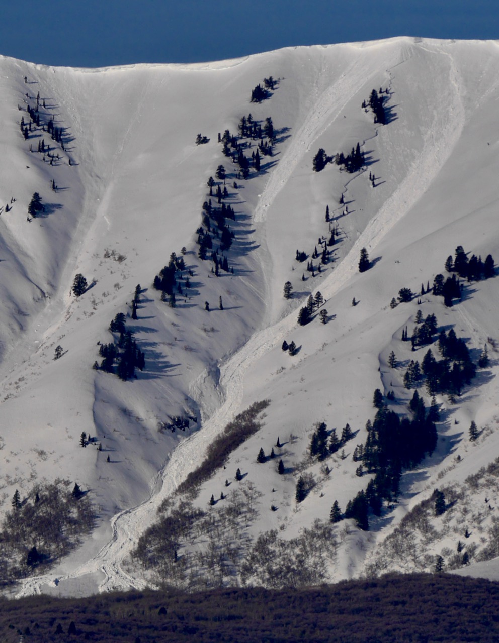
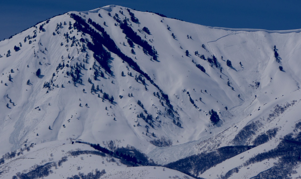
Exceptionally warm temperatures and intense sun will elevate the avalanche danger to HIGH on backcountry slopes steeper than 30°. Very dangerous avalanche conditions will develop, large natural cornice falls and wet avalanches will certainly occur in sunny terrain and are possible on steep slopes at all elevations.
*Wet avalanches on steep slopes at very low elevations and in the foothills may threaten unsuspecting people, children, or pets.
Low
Moderate
Considerable
High
Extreme
Learn how to read the forecast here
Avalanche Warning
What: The avalanche danger for the warning area will very quickly rise to HIGH today with daytime heating.
Where: For the mountains and foothills of Northern Utah, including the Wasatch Range...Bear River Range...Wellsville Range...Oquirrh Mountains...Stansbury Range...Cache Valley...Ogden Valley...Skyline...Uinta Mountains
Impacts: Warm temperatures and the intense sun will create widespread areas of unstable wet snow. Natural and human-triggered cornice falls and wet avalanches are likely. People should avoid being in avalanche terrain (off of and out from under slopes steeper than 30°) and stay clear of avalanche run-outs on all aspects and elevations.
Special Announcements
The final UAC report for the Upper Weber Canyon avalanche accident on March 9 has been published and is available HERE. The UAC would like to thank Park City Powder Cats for sharing information about the timeline of the accident and allowing UAC staff access to the avalanche after the incident.
Weather and Snow
Temperatures stayed well above freezing overnight, preventing a good refreeze of the saturated snow. Solar warming will quickly soften up the snow this morning, and very dangerous avalanche conditions will develop again. Above normal heat will also warm up and soften the snow on shady north facing slopes down low, where there is a ton of snow holding out this spring.
Avalanches are possible in places where people don't normally have to worry about avalanches this time of year, like on day hiking trails, along the rivers, and even on steep slopes in your neighborhood benches and foothills....
*PEOPLE SHOULD AVOID BEING IN AVALANCHE TERRAIN AND STAY CLEAR OF AVALANCHE RUNOUTS.
The 8400' Tony Grove Snotel reports 47° F and 137" of total snow. At the 9700' CSI Logan Peak weather station, it's 43° F and the wind is blowing from the south 30 to 40 mph, with gusts in the mid 50s.

Here is the NWS point forecast (36 hrs) for Logan Canyon:
Today: Sunny, with a high near 58. South southeast wind 9 to 13 mph.
Tonight: Mostly clear, with a low around 37. South wind 6 to 10 mph becoming east in the evening.
Wednesday: A 20 percent chance of showers after noon. Mostly sunny, with a high near 57. Southeast wind 5 to 15 mph becoming southwest in the afternoon.
Looks like cooler conditions, some clouds, and possible snow showers in the later part of the week.
Recent Avalanches
  • Widespread natural wet avalanches occurred in the past couple days in the Wellsville Range. Large natural cornice falls and overrunning loose avalanches triggered dangerously large wet slabs. I was glad to see no cars parked at the Rattlesnake TH Sunday, after seeing the huge debris pile from a massive natural avalanche....HERE
A recent large natural avalanche triggered by a cornice fall in the Wellsvilles. Rattlesnake Canyon, N Ridge of Mitton Pk, 4-9-23
  • A natural avalanche crossed the inside lane of Highway 89 at the Dugway in Logan Canyon at 6:30 Saturday evening, after most down canyon traffic had already passed.
  • A close call occurred on Tuesday in Hillyard Canyon, Cub River Idaho, when a rider triggered a soft slab avalanche, that caught and carried two others in his party. Both deployed airbags, and one ride was partially buried. The party had to probe for a sled which was found completely buried about 5' deep. report is HERE
  • For a list of recent avalanches in the Logan Zone go HERE, and there was lots of recent natural avalanche activity in the mountains of Northern Utah. Find a list of all recent observations & avalanches from across Utah HERE.
Ad
Avalanche Problem #1
Wet Snow
Type
Location
Likelihood
Size
Description
  • Expect warm temperatures and intense sun to elevate the danger of wet avalanches significantly at all elevations.
  • High angle April sun and seasonal warmth will quickly moisten the snow this morning and rapidly increase potential for wet avalanches.
  • Dangerous wet avalanche conditions have developed at all elevations including low elevations, especially on shady forested slopes and in steep northerly facing terrain.
Avalanche Problem #2
Cornice
Type
Location
Likelihood
Size
Description
The heat is causing dangerous conditions up high, especially in windy terrain, with huge deceptive cornices, and softening, thick previously formed wind slabs. Large cornice falls and several feet thick wet slabs are likely at upper elevations. Warm temperatures have increased the likelihood of natural cornice failures, and some will certainly calve off large pieces. These are likely to trigger avalanches on slopes below.
  • People should stay well away from and off of slopes under the HUGE overhanging cornices, which are found on the major peaks and ridges.
  • Avoid corniced slopes and stiffer drifts on steep slopes near ridges and in and around terrain features like cliff bands, sub-ridges, mid-slope break-overs, and gully walls.
Additional Information
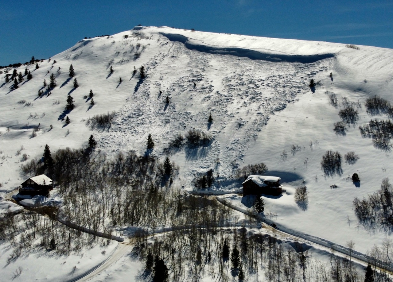
Last week an avalanche of wind drifted snow came pretty close to a couple houses in Garden City near Bear Lake
This fresh large natural wet avalanche in Old Logway Canyon in the Wellsvilles was visible from across Cache Valley yesterday morning. (4-10-23)
General Announcements
  • Please submit your observations from the backcountry HERE.
  • For a list of avalanche classes from the Utah Avalanche Center go HERE
  • For information on where you can ride your sled or snow-bike, check out this map of the winter travel plan for the Logan and Ogden Ranger Districts HERE, and a close up of the Tony Grove and Franklin Basin Areas HERE.
This forecast is from the U.S.D.A. Forest Service, which is solely responsible for its content. This forecast describes general avalanche conditions and local variations always occur.