Issued by Toby Weed on Wednesday morning, April 10, 2019
MODERATE: Heightened avalanche conditions exist on mid and lower elevation slopes, with human triggered and natural wet loose and wet slab avalanches possible. Expect increasing danger of new snow and wind slab avalanches today as fresh snow accumulates and is drifted into avalanche starting zones at upper elevations.
Avoid travel in gullies and on or below steep slopes with melt-softened saturated snow.
Thank you to everyone who supported our spring fundraiser. We reached and even exceeded our goals. The Utah Avalanche Center could not exist without your support.
Spring is here and it is time to adjust our travel. Learn what to watch for during spring avalanche conditions when the snow becomes wet. Watch our Spring video HERE
Weather and Snow
The storm brought rain to Cache Valley and a few inches of fresh snow to the mountains, but most importantly, colder temperatures. The Tony Grove Snotel stopped updating last night, so I don't know how much new snow there is up there, but the remote depth sensor on Beaver Mountain reports 4 inches in the last 24 hours. It's 26ºF at the UDOT Hwy 89 Logan Summit station this morning. I'm reading 18ºF at the 9700' CSI Logan Peak weather station, and northwest winds are averaging 25 mph, with gusts in the 40s.
Mountain temperatures dropped below freezing for the first time in several days, but a few inches of fresh snow insulated the melt-softened saturated snow at mid elevations, and rain fell on lower elevation snow for much of the day yesterday, so wet avalanches will still be the number one problem today. Accumulations of fresh snow and drifting from blustery north-northwest winds will cause rising avalanche danger at upper elevations, and avalanches of new and wind drifted snow will become more possible for people to trigger by afternoon.
The cold spring storm system will continue east across Utah today. Cool and unsettled conditions will persist through the end of the week. Snow is falling in the mountains this morning and it'll continue throughout the day, with 3 to 7 inches of accumulation possible. High temperatures at 8500' are expected to be around 26ºF, with 28 to 30 mph north-northwest wind, gusting to around 41 mph. Snow showers are likely tonight, with 1 to 2 inches possible. Expect low temperatures around 18ºF, and 21 to 30 mph north-northwest winds. There's a 50% chance of snow showers tomorrow, with 1 to 2 inches possible. It'll be mostly cloudy, with high temperatures around 31ºF.
Recent Avalanches
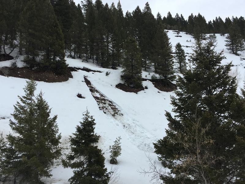
Cloud cover and cooler temperatures kept wet avalanche activity to a minimum in the past couple days, but it stayed above freezing in many areas at night, and snow remains soft and saturated throughout on many slopes. We noticed a recent natural wet loose avalanche in Beaver Creek Canyon that entrained all the snow, running on the ground.
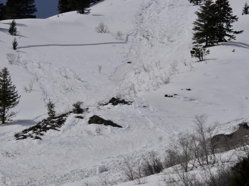
Numerous fairly large natural wet loose and a few wet slab avalanches occurred late last week across the Logan Zone. Wet loose and wet slab avalanches occurred with daytime solar warming.
A natural wet loose avalanche overrunning a steep mid elevation slope, triggered a wet slab avalanche and created quite a mess below Mitton Peak in the Wellsville Mountain Wilderness (4/5/19).
Natural wet loose and wet slab avalanches were widespread in the Bear River and Wellsville Mountain Ranges last week.
Avalanche Problem #1
Wet Snow
Type
Location
Likelihood
Size
Description
Temperatures finally dipped below freezing last night, but a few inches of snow insulated the warm wet snow at mid elevations and rain fell on lower elevation snow. Wet loose and wet slab avalanches will again be possible for people to trigger, and natural wet activity is possible. Continue to avoid being on or under steep slopes with melt-softened saturated snow, and stay out of runout gullies.
Avalanche Problem #2
Wind Drifted Snow
Type
Location
Likelihood
Size
Description
Expect increasing avalanche danger as new snow stacks up and is drifted onto steep slopes in upper elevation terrain. Avalanches involving new or drifted snow could entrain wet snow in descent and might grow to become large and destructive on sustained slopes.
Avoid drifted new snow on the lee side of major ridges and in and around terrain features like sub-ridges, gullies, scoops, rocky outcrops, cliffs, and tree stringers.
Stay off and out from under large ridge top cornices, which are likely to break further back than expected, and could trigger avalanches on steep slopes below.
Additional Information
I will update this forecast Friday morning.
General Announcements
Now is a great time to practice companion rescue techniques with your backcountry partners. You should check out and use the new Avalanche Beacon Training Park we set up at the Franklin Basin trailhead. Special thanks to Northstars Ultimate Outdoors, USU Outdoor Program, and Beaver Mountain Ski Patrol for helping us to make this possible.
Check out the improved weather links, road conditions, and weather links for each forecast region on the new UAC IOS App. Do you use the NOAA point forecast? If so, now you can bookmark your favorite weather locations in "My Weather" in the App. HERE
Are you new to the backcountry or looking to refresh your skills? The UAC has released a free 5-part avalanche skills eLearning series. HERE
If you would like to get the daily advisory by email you subscribe HERE.
Support the UAC through your daily shopping. When you shop at Smith's, or online at REI, Backcountry.com, Patagonia, NRS, Amazon, eBay by clicking on these links, they donate a portion of your purchase to the UAC. If you sell on eBay, you can have your See our Affiliate Page for more details on how you can support the UAC when you shop
Remember your information can save lives. If you see anything we should know about, please help us out by submitting snow and avalanche observations.HERE You can call us at 801-524-5304, email by clicking HERE, or include #utavy in your Instagram.
This forecast is from the U.S.D.A. Forest Service, which is solely responsible for its content. The forecast describes general avalanche conditions and local variations always occur.