Forecast for the Logan Area Mountains

Toby Weed
Issued by Toby Weed for
Friday, April 1, 2022
Much colder overnight temperatures locked up the saturated snow, formed a solid melt-freeze crust on top of it, and created generally stable snow conditions. Avalanches are unlikely and the danger LOW in the backcountry today. Get an early start, so you can get off the snow early before it is softened by seasonal midday warmth. If you start sinking into soft saturated snow, it's time to change your route, get off and out from under slopes steeper than 30°, or head home.
Use normal caution
Low
Moderate
Considerable
High
Extreme
Learn how to read the forecast here
Special Announcements
We'd like to thank our incredible community for your support of the 2022 Spring Campaign. We raised $75,000 in two weeks to help grow our avalanche forecasting program. Thank You!
Weather and Snow
Temperatures dropped well below freezing last night at all elevations. I'm reading 27°F at the airport in Logan and 18°F at 9700' near the summit of Logan Peak. The welcome cold temperatures put a hold on the meltdown and formed a pretty solid and thick melt-freeze crust on top of the saturated snow. In this refrozen state, wet snow is stable and avalanches are generally unlikely. With clear skies today, high angled sun and seasonal daytime warmth will probably soften up the saturated surface snow a bit, and if you start sinking into wet snow, it's time to reevaluate your route.

The 8400' Tony Grove Snotel reports 22°F this morning, and a couple inches of snow containing around 0.6" SWE. There is 58 inches of total snow at the site, containing 73% of normal SWE for the date. Northwest winds are blowing around 15 mph at the 9700' CSI Logan Peak weather station, where overnight temperatures dropped below freezing for the third night in a row, and it's 18°F.
  • Expect sunny skies today, with high temperatures at 8500' around 38°F and 10 to 15 mph west winds.
  • It will be partly cloudy tonight with low temperatures around 23°F and 10 to 13 mph winds blowing from the southwest.
  • Tomorrow will be partly sunny, with high temperatures pushing 46°F. It will be rather breezy, with west-southwest winds blowing 15 to 25 mph with gusts around 35 mph.
  • It should be sunny on Sunday, with high temperatures around 45°F and 15 mph north winds.
  • Unsettled weather is expected for the early part of next week, with snow showers, clouds, and cool mountain temperatures.
Recent Avalanches
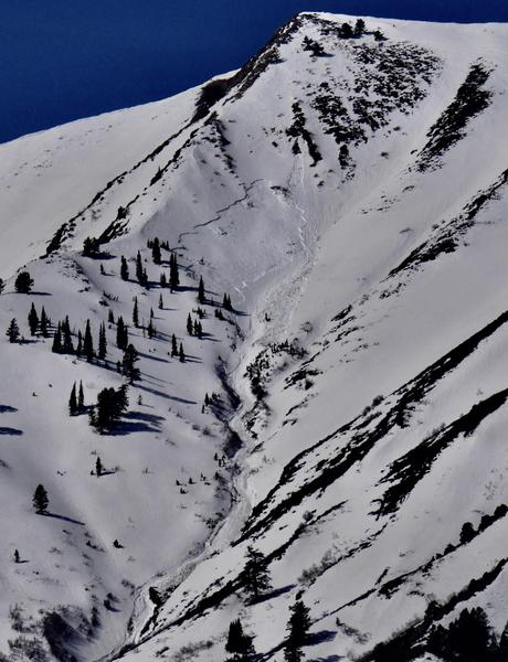
Conditions are quite a bit different this weekend than last, with much colder temperatures and much more stable snow in the backcountry. Last weekend's exceptionally warm weather caused a fairly widespread natural wet avalanche cycle in the Logan Zone, with large wet slab and wet loose avalanches observed, especially widespread in the Wellsville Range.
A large natural wet slab avalanche from last Saturday (3-26-22), likely triggered by a wet loose avalanche overrunning the slope, in Bird Canyon off Mendon Peak in the Wellsville Mountain Wilderness.
Check out all the recent backcountry observations and many recent avalanche reports from across Utah HERE.
Ad
Avalanche Problem #1
Normal Caution
Type
Location
Likelihood
Size
Description
As daytime temperatures rise and the high angled sun warms the snow surface today, it is possible people could trigger wet avalanches on slopes steeper than 30°. Freezing temperatures overnight created a supportable surface crust and helped to stabilize the sloppy wet snow. But, the high angled sun and seasonally warm daytime temperatures will soften saturated surface snow again, and although fairly unlikely, wet avalanches are possible in the backcountry again today.
  • Get an early start so you can reach your objective and head down before the snow becomes soft and less stable.
  • If you start sinking into saturated snow, it's time to reevaluate your route, stay off and out from under slopes steeper than 30°, and/or head home.
  • Wet slushy snow is generally unstable on steep slopes.
Additional Information
  • Now is a great time to practice your avalanche rescue skills. Thanks to the generous support of Northstar, the Franklin Basin Beacon Training Park is up and running. The park is located directly west of the parking lot and is open for anyone to use. All you need is your beacon and probe. Please do not dig up the transmitters.
  • Always follow safe backcountry travel protocols. Go one person at a time in avalanche terrain, while the rest of your party watches from a safe area. (practice anytime while traveling on or under backcountry slopes steeper than 30°)
  • Check your avalanche rescue equipment, change your batteries, and practice often with your backcountry partners.
    Check slope angles, and to avoid avalanche terrain stay off of and out from under slopes steeper than 30° and adjacent slopes. Video Here
General Announcements
Special thank you to Polaris and Northstar...Video Here
Who's up for some free avalanche training? Get a refresher, become better prepared for an upcoming avalanche class, or just boost your skills. Go to https://learn.kbyg.org/ and scroll down to Step 2 for a series of interactive online avalanche courses produced by the UAC.
  • Please submit your observations from the backcountry HERE.
This information does not apply to developed ski areas or highways where avalanche control is normally done. This forecast is from the U.S.D.A. Forest Service, which is solely responsible for its content. This forecast describes general avalanche conditions and local variations always occur.