Forecast for the Logan Area Mountains

Toby Weed
Issued by Toby Weed for
Sunday, March 5, 2023
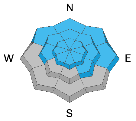
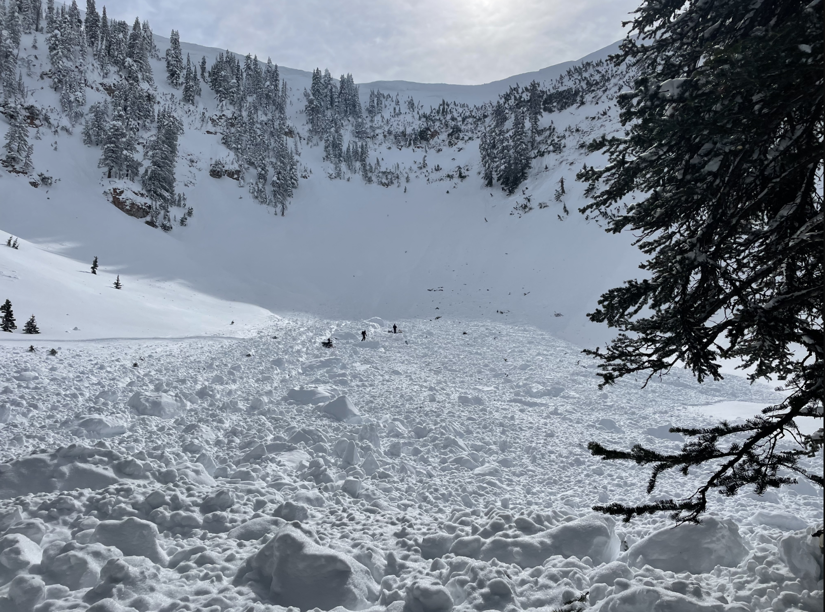
Dangerous avalanche conditions exist on backcountry slopes steeper than 30° at all elevations, and the danger is HIGH. People are likely to trigger soft slab or loose avalanches of storm snow, large cornice falls, or 1 to 4' thick slab avalanches of wind drifted snow, perhaps failing on a buried persistent weak layer. Long running natural avalanches are also probable, so people should stay clear of avalanche paths and runout zones. Excellent snow cover at low elevations means that slopes are smooth and primed, and even soft avalanches of storm snow could impact people and infrastructure.
  • Avoid being on or under backcountry slopes steeper than 30°
Low
Moderate
Considerable
High
Extreme
Learn how to read the forecast here
Special Announcements
To help you safely enjoy the backcountry, the UAC team is constantly evaluating and implementing new programs and technologies. Donate to the Spring Campaign to help our team implement innovative tools and better provide you with the information you rely on.
Weather and Snow
The danger should diminish fairly quickly, since heavy snowfall has apparently tappered off in the Bear River Range. Natural avalanches probably occurred overnight on many slopes in the backcountry, and more are possible today. It would be a good day to play in the meadows way out from under steep hills or catch a ride on the lifts.
This week people remotely triggered a few large avalanches on drifted slopes. Huge conices formed with the recent storm, and they continue to build today with drifting by winds from the southwest. The overnight storm dropped a ton of snow at lower elevations, and the new snow itself is likely to be unstable initially. Heavy snow and drifting increased the load and thickened wind slabs overloading backcountry slopes, some with poor snow structure and buried persistent weak layers.

The 8400' Tony Grove Snotel reports 14 inches of new snow from overnight, with 1.2" SWE . It's 15° F this morning, and there is 140 inches of total snow. The wind is blowing from the southwest around 25 mph, having gusted into the 50s at the 9700' CSI Logan Peak weather station.
Here is the NWS point forecast for high elevations in the Central Bear River Range:
Today: A 40 percent chance of snow before 11am. Areas of blowing snow before 11am. Partly sunny, with a high near 20. Wind chill values as low as -3. Southwest wind 14 to 20 mph, with gusts as high as 30 mph. Total daytime snow accumulation of less than one inch possible.
Tonight: Snow, mainly before 11pm. Low around 6. Wind chill values as low as -4. West southwest wind around 9 mph. Chance of precipitation is 80%. New snow accumulation of 2 to 4 inches possible.
Monday: Snow likely, mainly after 11am. Mostly cloudy, with a high near 18. Wind chill values as low as -6. West southwest wind 9 to 14 mph. Chance of precipitation is 60%. New snow accumulation of less than one inch possible.

Unsettled and cold weather will continue, and although we're not seeing big storms, a bit more snow is likely to fall next week.
Recent Avalanches
  • Thursday, riders remotely triggered a large avalanche in the southernmost bowl off Red Pine Ridge, in Richard's Hollow or the backside of Providence Canyon. (9000', east facing), video HERE
  • Wednesday, a rider lost his sled to a large cornice fall off the ridge west of Logan Peak, which triggered a large avalanche in the Cirque in Logan Dry Canyon below. The rider jumped off the sled as it went over the edge and the fully buried and broken sled was recovered on Thursday. report HERE
  • Skiers remotely triggered a large avalanche in the Beaver Mountain Backcountry Tuesday. The 2' deep and 600' wide avalanche off the south ridge of Beaver Mountain is on an east facing slope at 8000', and it was triggered by a skier hundreds of feet away. report is HERE
  • Tuesday, I could see evidence of widespread long running natural avalanches in the Wellsvilles, with most paths having slid. Bench crashers! Some ran full length of their paths, way overrunning debris from previous events.. On Thursday, I visited Maple Bench to look at extensive naturals from earlier in the week, and to the runout from Bird Canyon, which ran full length of path (~3000vrt') and well into maples below.
  • A natural avalanche Monday morning ran ~1250 vrt' to Green Canyon bottom less than 100' from access road to popular trailhead at about 5000' in elevation.

  • For a list of avalanches in the Logan Zone go HERE
    Find a list of all recent observations & avalanches from across Utah HERE.
Ad
Avalanche Problem #1
Wind Drifted Snow
Type
Location
Likelihood
Size
Description
This morning winds are blowing from the southwest, and they are strong enough to drift the settled powder. Avalanches of wind drifted storm snow, 1 to 4 feet thick, are possible on drifted slopes at all elevations, but will be larger and even more likely for people to trigger on upper and mid elevation slopes facing northwest through southeast.
  • Avoid corniced slopes and stiffer drifts on steep slopes near ridges and in and around terrain features like cliff bands, sub-ridges, mid-slope break-overs, and gully walls.
  • Wind slabs consist of stiffer drifted snow.
  • The overhanging cornices on the high peaks and ridges have become huge and unstable with recent storms, so stay well away and out from under them.
  • Some wind slab avalanches could fail on a sugary persistent weak layer, and some might be triggered remotely.
Avalanche Problem #2
Persistent Weak Layer
Type
Location
Likelihood
Size
Description
The Persistent Weak Layer problem is widely scattered across terrain, where thin layers of sugary snow or other weak snow grains exist only in isolated pockets, but on most aspects. At lower elevations in the Logan Zone layers of sugary faceted snow are more widespread in areas with shallower snow cover (<4') and more prevalent on northerly facing slopes.
  • Avalanches failing on a persistent weak layer are possible at all elevations but are notably also still possible down lower, below about 7000' elevation.
  • Avalanches could be triggered remotely or from a distance.
Avalanche Problem #3
New Snow
Type
Location
Likelihood
Size
Description
  • Natural soft slab and loose avalanches of storm snow are likely this morning at all elevations. Avalanche paths are filled in and "greased" so some natural avalanches could run far out onto the flats.
  • People are likely to trigger avalanches if they venture into avalanche terrain today.
  • Loose wet avalanches entraining significant piles of moist storm snow are possible on sunny slopes at all elevations.
Additional Information
Stay well clear of the freshly swollen cornices, which are likely to break further back than you might expect and could trigger avalanches on slopes below.
A cornice broke further back than expected , and it took a sled for a nasty ride. Luckily the rider was able to jump off the sled before it went over the edge and was swept into a large avalanche and buried.
The cornice fall triggered a large avalanche below in the Cirque in Logan Dry Canyon, which damaged and completely buried the sled.
General Announcements
  • Please submit your observations from the backcountry HERE.
  • For a list of avalanche classes from the Utah Avalanche Center go HERE
  • For information on where you can ride your sled or snowbike, check out this map of the winter travel plan for the Logan and Ogden Ranger Districts HERE, and a close up of the Tony Grove and Franklin Basin Areas HERE.
This forecast is from the U.S.D.A. Forest Service, which is solely responsible for its content. This forecast describes general avalanche conditions and local variations always occur.