31st Annual Backcountry Benefit - September 12th - Tickets Available Here!

Forecast for the Logan Area Mountains

Toby Weed
Issued by Toby Weed on
Thursday morning, March 30, 2023
Dangerous avalanche conditions have developed on slopes steeper than 30° at all elevations in the backcountry. Periods of heavy snowfall and drifting by increasing west wind will continue to elevate the danger. There is CONSIDERABLE danger on drifted slopes, especially in northerly facing terrain up high. Large natural cornice falls are possible, and these or people are likely to trigger 1 to 3-foot thick slab avalanches of wind drifted snow. Avalanches of storm snow are possible even in sheltered terrain, and last night's warmth and rain at lower elevations elevated the danger of wet avalanches entraining big piles of moist snow on very steep slopes.
  • Make conservative decisions, evaluate snow and terrain carefully.
  • Stay well away from and out from under ridge top cornices.
  • Avoid being on or below slopes with warmth or rain softened saturated snow.
Low
Moderate
Considerable
High
Extreme
Learn how to read the forecast here
Special Announcements
  • Thank you to everyone who donated to our Spring Campaign. We appreciate your support and look forward to creating new tools to help you stay safe in the backcountry.
  • We are sorry to confirm an avalanche fatality occurred Monday in the Oquirrh mountains. Preliminary report is HERE, https://utahavalanchecenter.org/avalanche/77465
Weather and Snow
Hopefully cooler temperatures and a dropping rain/snow line will help matters, but warm temperatures yesterday, and rain last night elevated potential for wet avalanches entraining big piles of moist snow on steep low elevation slopes. The still deep snow on very steep northerly facing slopes is most suspect, with real potential for natural wet avalanches coming out of the shady forest and over the cliffs.
The National Weather Service has continued a Winter Storm Warning for the northern Bear River Range. Heavy snowfall and drifting snow will continue to elevate backcountry avalanche danger today, and significant accumulations will probably create HIGH danger tonight with long running natural avalanches becoming likely.
The 8400' Tony Grove Snotel reports 8 inches of heavy new snow overnight. It's 25° F and there is 141" of total snow. The wind is blowing from the south-southwest 20 to 25 mph (with gusts close to 50 mph) at the 9700' CSI Logan Peak weather station.

Here is the NWS point forecast (36 hrs) for high elevations in the Central Bear River Range:
Today: Snow showers. High near 26. Wind chill values as low as 10. West wind 10 to 18 mph. Chance of precipitation is 100%. Total daytime snow accumulation of 3 to 5 inches possible.
Tonight: Snow. The snow could be heavy at times. Low around 19. Wind chill values as low as 2. Breezy, with a west southwest wind 20 to 22 mph, with gusts as high as 34 mph. Chance of precipitation is 100%. New snow accumulation of 10 to 14 inches possible.
Friday: Snow before noon, then snow showers after noon. The snow could be heavy at times. High near 27. Wind chill values as low as 6. Blustery, with a west wind 23 to 25 mph, with gusts as high as 38 mph. Chance of precipitation is 100%. New snow accumulation of 4 to 8 inches possible.

The National Weather Service has also issued a Winter Storm Warning for the Bear River Range and the rest of the Logan Zone south of the state line. Unsettled, cold, and snowy weather will last through the remainder of the week and the coming weekend, with a possibility of a bit of a break Friday night and (maybe some sun) Saturday.
Recent Avalanches
  • Widespread natural (direct action) avalanche activity occurred during each of the last few storms in the Logan Zone.
  • For a list of recent avalanches in the Logan Zone go HERE
  • It was a bit more active in the Wasatch Range in the last few days due to wind drifted snow. Find a list of all recent observations & avalanches from across Utah HERE.
Ad
Avalanche Problem #1
Wind Drifted Snow
Type
Location
Likelihood
Size
Description
This morning south winds continue to blow at upper elevations, and they continue to drift fresh snow into lee slope avalanche starting zones. Expect to find sensitive huge cornices and freshly formed wind slabs in drifted upper and mid elevation terrain.
  • Large natural cornice falls are possible, and/or 1' to 3' thick wind slabs are likely for people to trigger in windy terrain at upper and mid elevations.
  • Avoid corniced slopes and stiffer drifts on steep slopes near ridges and in and around terrain features like cliff bands, sub-ridges, mid-slope break-overs, and gully walls.
  • The overhanging cornices on the high ridges are huge this year, and recent storms have built them further out and made them unstable, so people should continue to stay well away and out from under them.
  • People are likely to trigger loose and soft slab avalanches of storm snow on steep slopes, and avalanches are possible even in more sheltered terrain.
Avalanche Problem #2
Wet Snow
Type
Location
Likelihood
Size
Description
​​​​​​Avalanches of wet snow are likely on low elevation slopes with loose saturated snow. Dangerous conditions exist, especially in very steep northerly facing terrain including on shady forested slopes.
  • Warm temperatures and rain on the snow elevated the danger of wet loose avalanches entraining large piles of moist snow.
  • Wet avalanches may be possible in unexpected places. We have seen numerous wet avalanches at low elevations this year even in places where we've not really seen any avalanches before.
Additional Information
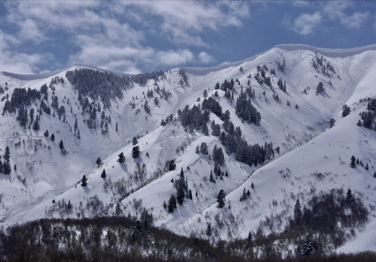
Very large and long running natural avalanches occurred in the Wellsville Mountain Wilderness with the last storm. (N Hell Canyon, 3-25-23)
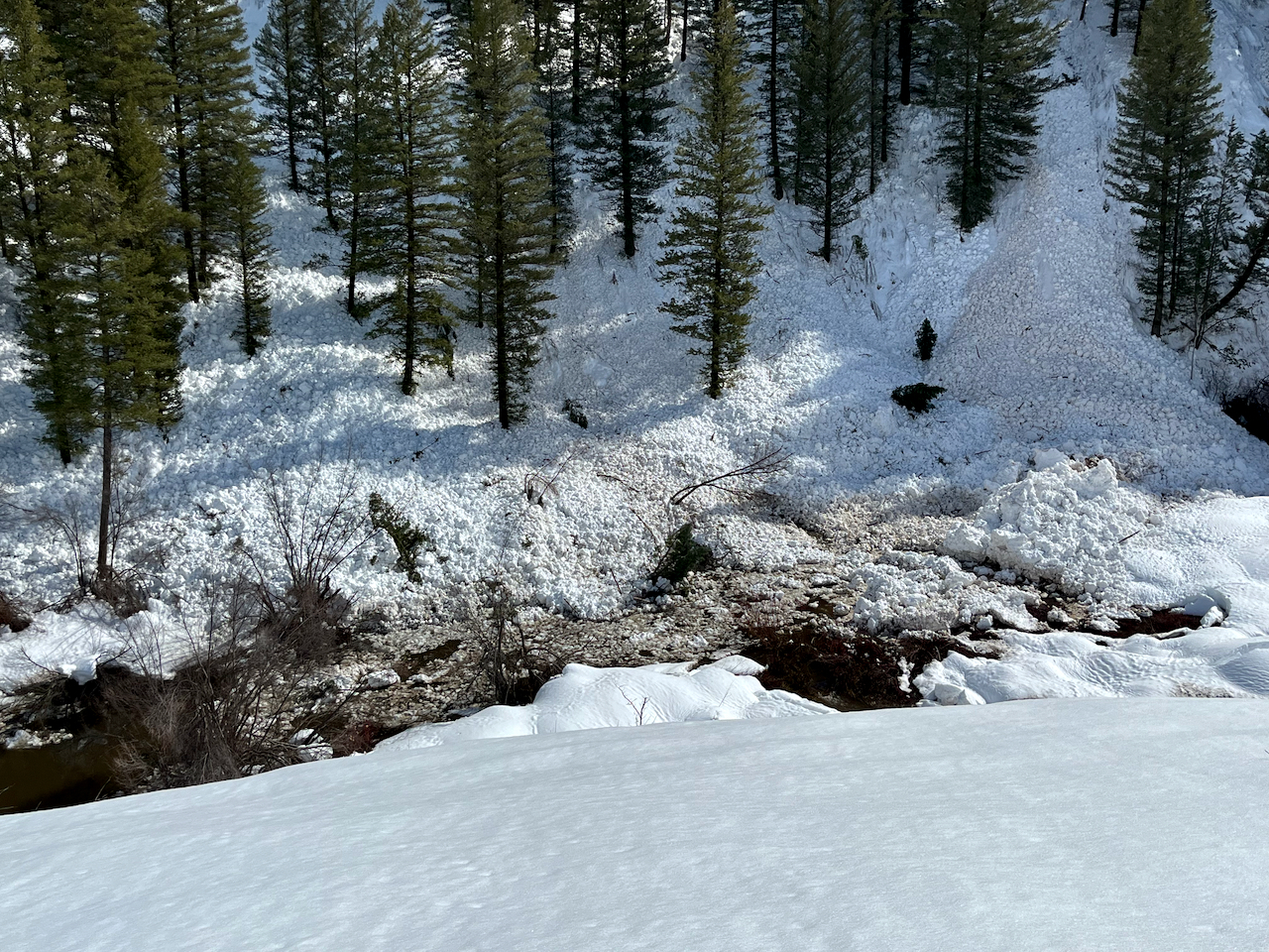
Rain on the snow and warm temperatures can cause dangerous wet avalanche conditions to develop at lower elevations, like on the steep slopes above the Logan River in Logan Canyon.
General Announcements
  • Please submit your observations from the backcountry HERE.
  • For a list of avalanche classes from the Utah Avalanche Center go HERE
  • For information on where you can ride your sled or snow-bike, check out this map of the winter travel plan for the Logan and Ogden Ranger Districts HERE, and a close up of the Tony Grove and Franklin Basin Areas HERE.
This forecast is from the U.S.D.A. Forest Service, which is solely responsible for its content. This forecast describes general avalanche conditions and local variations always occur.