Forecast for the Logan Area Mountains

Toby Weed
Issued by Toby Weed for
Wednesday, March 30, 2022
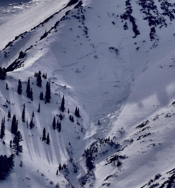
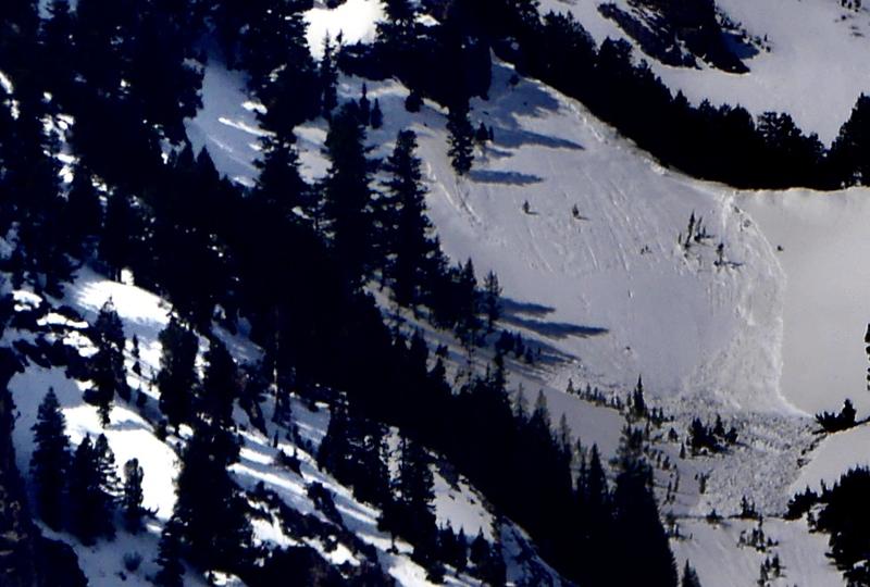
Much cooler temperatures and clear skies last night slowed the meltdown and created a supportable surface crust. This is helping to stabilize the sloppy snow, and has likely put a lid on natural wet avalanche activity. Heightened avalanche conditions and MODERATE danger remain on northerly facing slopes with poor snow structure. When the high angled sun comes out today, and as midday temperatures rise, the surface crusts will soften and people could trigger wet loose or serious wet slab avalanches on slopes steeper than 30°.
Evaluate snow and terrain carefully, and consider changing your plans if you start sinking into sloppy wet snow.
Low
Moderate
Considerable
High
Extreme
Learn how to read the forecast here
Special Announcements
The 2022 Spring Campaign wraps up Thursday. We still need your support to help the UAC improve our avalanche forecasting services. Please make a donation today, and thank you to everyone who has supported our work this season. HERE
Weather and Snow
Very warm temperatures in the past few days caused elevated conditions for wet avalanches at all elevations across the zone. Although mostly damp now, weak sugary faceted snow still exists on northerly facing slopes creating poor snow structure, and people could trigger dangerous avalanches. Wet loose and wet slab avalanches are possible, with wet slabs most possible in very steep terrain around or under cliff bands. The snow in the backcountry yesterday was sloppy wet and unsupportable in many places, and you post-hole into slushy snow if you get off your sled. Cooler temperatures and clear skies last night created a supportable surface crust and helped to stabilize the snow, but high angled sun and daytime warmth today will probably soften things up again.
Paige found very sloppy, unsupportable, wet snow in the Tony Grove Area on Monday

The 8400' Tony Grove Snotel reports another inch of new snow overnight. It's 30°F this morning, and there is 59 inches of total snow at the site, containing 73% of normal SWE for the date. Northwest winds are blowing around 25 mph at the 9700' CSI Logan Peak weather station, where overnight temperatures dropped significantly, and it's 20°F this morning.

  • Today will be sunny, with high temperatures at 8500' around 43°F and 15 mph northwest winds.
  • Expect mostly cloudy skies tonight, with a chance of snow showers after midnight. Low temperatures will be around 25°F and west winds will blow 10 to 15 mph.
  • Tomorrow will be mostly cloudy, with a high temperature around 37°F and 11 to 17 mph west winds. There is a good chance of snow showers and 1 or 2 inches of snow could accumulate on upper elevation slopes.
  • Tomorrow will be sunny, with high temperatures near 43°F and 15 to 20 mph winds blowing from the north-northwest.
  • Temperatures could drop into the teens tomorrow night, and fair weather is expected in the mountains Friday and Saturday.
Recent Avalanches

A fresh natural slab avalanche in Bird Canyon was visible from across Cache Valley Saturday afternoon.
  • Despite poor viewing conditions and flat light the last couple days, we could see numerous significant fresh wet avalanches in the Bear River and Wellsville Ranges from the weekend's exceptionally warm weather.
  • We observed several sizable fresh natural avalanches this weekend in the Wellsville Mountain Wilderness. Both wet loose and wet slab avalanches are still quite visible from across Cache Valley.

Check out all the recent backcountry observations and many recent avalanche reports from across Utah HERE.
Ad
Avalanche Problem #1
Wet Snow
Type
Location
Likelihood
Size
Description
Wet Slab Avalanches:
As daytime temperatures rise and the high angled sun comes out in force, it is possible people could trigger dangerous (wet) slab avalanches on slopes facing the north half of the compass, failing on a sugary, buried persistent weak layer, which is now pretty moist in most places. Last week's warmth softened existing slabs and crust layers, and increased creep and glide rates, which caused natural wet loose and wet slab avalanches in steep terrain.
This large natural wet slab avalanche in the "Picture Window" area of Pine Canyon appears to have occurred on Sunday morning, since we did not see it with the glass on Saturday afternoon.
Cooler temperatures overnight and clear skies created a surface crust and helped to stabilize the sloppy wet snow. But, the high angled sun will be out in force and warm daytime temperatures will soften things up again, and wet loose avalanches remain possible in the backcountry today. When the snow surface becomes damp or unsupportable, it's time to head home. Watch for signs of heat-related instability like rollerballs, pinwheels, or sluffs of saturated surface snow. Wet slushy snow is generally unstable on steep slopes.
Additional Information
  • Now is a great time to practice your avalanche rescue skills. Thanks to the generous support of Northstar, the Franklin Basin Beacon Training Park is up and running. The park is located directly west of the parking lot and is open for anyone to use. All you need is your beacon and probe. Please do not dig up the transmitters.
  • Always follow safe backcountry travel protocols. Go one person at a time in avalanche terrain, while the rest of your party watches from a safe area. (practice anytime while traveling on or under backcountry slopes steeper than 30°)
  • Check your avalanche rescue equipment, change your batteries, and practice often with your backcountry partners.
    Check slope angles, and to avoid avalanche terrain stay off of and out from under slopes steeper than 30° and adjacent slopes. Video Here
General Announcements
Special thank you to Polaris and Northstar...Video Here
Who's up for some free avalanche training? Get a refresher, become better prepared for an upcoming avalanche class, or just boost your skills. Go to https://learn.kbyg.org/ and scroll down to Step 2 for a series of interactive online avalanche courses produced by the UAC.
  • Please submit your observations from the backcountry HERE.
This information does not apply to developed ski areas or highways where avalanche control is normally done. This forecast is from the U.S.D.A. Forest Service, which is solely responsible for its content. This forecast describes general avalanche conditions and local variations always occur.