Donate to the 2024 Spring Campaign to help rebuild the UAC website.

Forecast for the Logan Area Mountains

Toby Weed
Issued by Toby Weed for
Friday, March 29, 2019
MODERATE: Mountain temperatures dipped into the mid twenties overnight, and this should set up and stabilize the wet snow from this week's warm spell. A few inches of fresh snow was drifted by northwest winds overnight in exposed terrain. Shallow human triggered avalanches of wind drifted new snow are possible on upper elevation slopes facing northwest, north, northeast, east and southeast.
Evaluate snow and terrain carefully.
Low
Moderate
Considerable
High
Extreme
Learn how to read the forecast here
Special Announcements
We need your help. In an effort to increase awareness and prevent future fatalities we need to reach more people with our daily avalanche forecasts, expand the Know Before You Go program, and increase the number of on-snow avalanche courses. Please consider a donation to the UAC to help us raise $25,000 by April 8. Show your support of the UAC by making a donation at https://utahavalanchecenter.org/donate
Weather and Snow
The Tony Grove Snotel at 8400' reports about 3 inches yesterday, and 3 more overnight, with .6" SWE in the last 24 hours. It's 24 ºF this morning and there is 85" of total snow with 102% of average SWE for the date. It's 18 ºF at the 9700' CSI Logan Peak weather station, and northwest winds are currently averaging around 20 mph, gust of 43 mph. Mountain temperatures dropped well below freezing, which will set up the saturated snow, and put a lid on wet avalanche activity for now. A few inches of new snow fell last night, capping a few inches from yesterday. So expect shallow powder on a supportable but soft melt-freeze crust in most areas today.

Snow showers are likely in the mountains today, with 2 to 4" possible. High temperatures at 8500' are expected be around 30 ºF, with 17 to 21 mph west wind. Snow showers will continue tonight, with 1 to 3 inches possible, low temperature around 22º F, and 8 to 14 mph mph west winds. It'll be mostly cloudy tomorrow, with 36 ºF high temperatures and 5 to 8 mph west-southwest wind.
Recent Avalanches
It was active in the backcountry early this week, with riders triggering numerous wind and soft slab avalanches in the Central Bear River Range and widespread natural wet loose avalanches in sunny terrain.
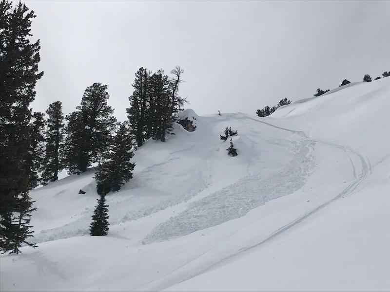
A snow bike triggered avalanche from the Saint Charles Peak Area on 3/26/19
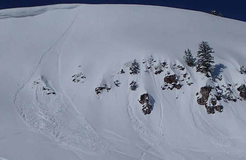
Natural wet loose avalanches were widespread on sunny slopes earlier this week.
  • A natural wet slab avalanche that snapped a few trees was observed Tuesday 3/26/19 across the Crimson trail in lower Logan Canyon.
  • A skier was caught, carried, and mostly buried while skinning up a drifted slope near Perry Reservoir on Monday, 3/25/19. Report is HERE
  • Saturday, 3/23/19, a skier triggered a scary 1 to 2 foot deep and 150' wide avalanche running on a buried persistent weak layer near Danish Pass. The avalanche ran on a 32 degree, north-northeast facing slope at around 8800' in elevation. Report is HERE
Ad
Avalanche Problem #1
Wind Drifted Snow
Type
Location
Likelihood
Size
Description
It will be possible for people to trigger shallow wind slab avalanches consisting of drifted new snow at upper elevations.
  • Use caution in upper elevation areas where drifts form, like on the lee side of major ridges and in and around terrain features like sub-ridges, gullies, scoops, tree stringers, and cliff bands.
  • Stay off and out from under large ridge top cornices, which are likely to break further back than expected and could trigger avalanches on steep slopes below.
Avalanche Problem #2
Persistent Weak Layer
Type
Location
Likelihood
Size
Description
Avalanches failing on a buried persistent weak layer are unlikely but still possible on isolated upper elevation slopes and in sheltered generally north facing terrain.
Additional Information
I will update this forecast tomorrow morning.
General Announcements
The new weather station at the WSU Bloomington Canyon Yurt is up and running. Data available HERE
Now is a great time to practice companion rescue techniques with your backcountry partners. You should check out and use the new Avalanche Beacon Training Park we set up at the Franklin Basin trailhead. Special thanks to Northstars Ultimate Outdoors, USU Outdoor Program, and Beaver Mountain Ski Patrol for helping us to make this possible.
The Beaver Mountain Backside is the backcountry, and it is avalanche terrain. Same goes for the steep rocky terrain adjacent to Cherry Peak Resort. If you leave a ski area boundary, you and your partners should carry and practice with avalanche rescue equipment and follow safe backcountry travel protocols.
Check out the improved weather links, road conditions, and weather links for each forecast region on the new UAC IOS App. Do you use the NOAA point forecast? If so, now you can bookmark your favorite weather locations in "My Weather" in the App. HERE
Are you new to the backcountry or looking to refresh your skills? The UAC has released a free 5-part avalanche skills eLearning series. HERE
If you would like to get the daily advisory by email you subscribe HERE.
Support the UAC through your daily shopping. When you shop at Smith's, or online at REI, Backcountry.com, Patagonia, NRS, Amazon, eBay by clicking on these links, they donate a portion of your purchase to the UAC. If you sell on eBay, you can have your See our Affiliate Page for more details on how you can support the UAC when you shop
Remember your information can save lives. If you see anything we should know about, please help us out by submitting snow and avalanche observations. HERE You can call us at 801-524-5304, email by clicking HERE, or include #utavy in your Instagram.
This forecast is from the U.S.D.A. Forest Service, which is solely responsible for its content. The forecast describes general avalanche conditions and local variations always occur.