Forecast for the Logan Area Mountains

Toby Weed
Issued by Toby Weed on
Thursday morning, March 26, 2026

The avalanche danger is MODERATE in the backcountry. Despite cooler temperatures and a breeze, wet avalanches will become possible, especially in sheltered sunny terrain and on rocky slopes with thin snow cover.

Heightened wet avalanche conditions exist, and people should evaluate the snow and terrain carefully and continue to avoid travel on or under slopes steeper than 30 degrees in the heat of the day.

Low
Moderate
Considerable
High
Extreme
Learn how to read the forecast here
Special Announcements

Spring Campaign and Spring Auction - Each spring, we ask for your continued financial support to fund our forecasting and education programs. We hope you will consider supporting our mission by checking out our campaign and auction, live and available HERE.

Weather and Snow

Without a significant refreeze of the saturated snow for well over a week, heightened wet avalanche conditions exist in the backcountry. Loose wet avalanches are likely in many areas, and devious, destructive wet slab avalanches are possible on steep rocky slopes with shallow, melt-softened, saturated snow. Overnight low temperatures at the highest elevations stayed far too warm again overnight, but are dropping this morning, and cooler temperatures and a breeze are expected in the mountains today. Today, you can expect to find a thin supportable crust in the morning with rough, dusty snow surfaces. The surface crust will soften during the day in the hot sun, and especially in sheltered terrain, the snow will become less supportable and punchy or sloppy. The snow is so soft and saturated in many areas that you post-hole right to the ground if you hop off your sled. Predicting the timing of wet avalanches is hard because the snow softens and becomes unstable at different elevations and aspects at different times. Given the uncertainty, your safest option is to avoid riding on or under steep slopes. Certainly, the risk is not worth the reward today.

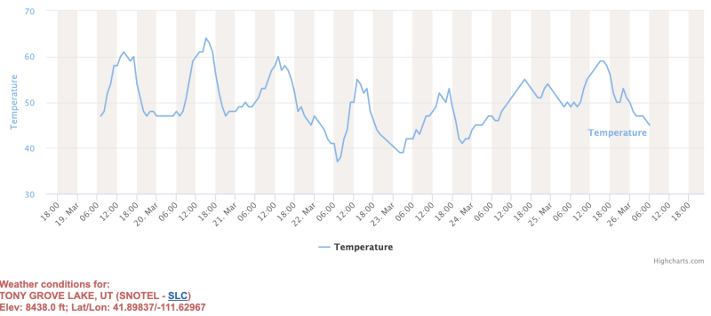
The snow has been rapidly melting in the record heat, but temperatures are starting to drop a bit this morning in the mountains. At 0500, the UAC Card Canyon weather station at 8700 feet reports 40°F and 40.4 inches of total snow. It's 45°F at the Tony Grove Snotel, with 49 inches of total snow. On Logan Peak, winds are blowing from the west 22 to 33 mph. It's 37°F on Paris Peak at 9500 feet, and the winds are from the west, blowing 22 to 30 mph. It will be mostly sunny in the mountains again today, but it will also be breezy and much cooler. Temperatures at around 8500 feet in the Logan Zone will reach around 41°F, with a ventilating breeze blowing from the northwest. Overnight, temperatures will drop below freezing at upper elevations for the first time in well over a week. Expect a few clouds tomorrow, with unseasonably warm and mostly sunny conditions expected through the weekend. A shift in the pattern is expected next week, with cooler and wetter conditions (snow in the mountains), Tuesday onward...

Coverage is still pretty good at upper elevations in the Central Bear River Range, though the snow is rough, dusty, and debris-covered.

Recent Avalanches

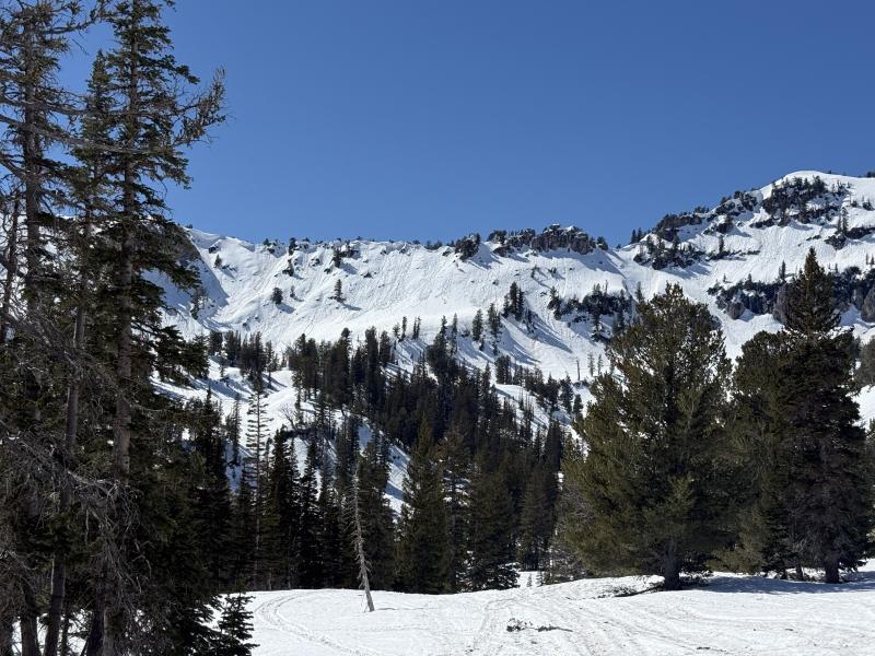
Over the last week across the Logan Zone, we've observed numerous natural wet avalanches caused by the extreme heat wave. Yesterday, there were a few more natural wet avalanches visible in the Wellsville Mountain Wilderness.

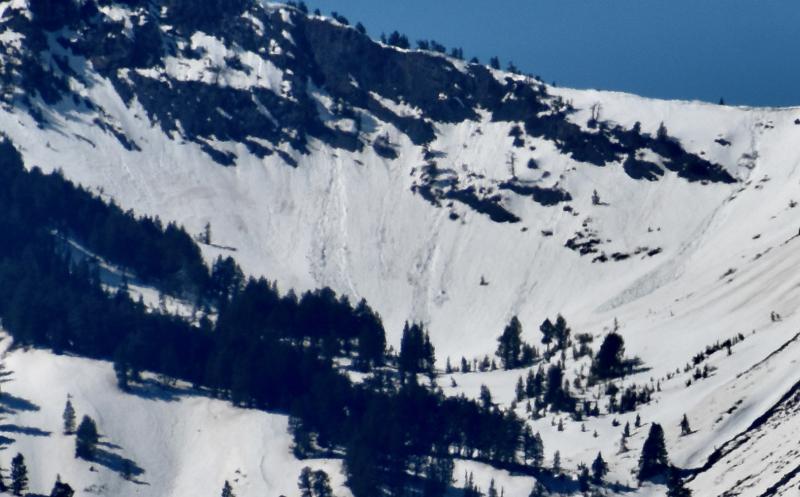
Recent natural wet avalanches are visible from the valley in the Box Elder Cirque in the Wellsville Mountain Wilderness.

Find observations from the Logan Zone and from across the state HERE.

Avalanche Problem #1
Wet Snow
Type
Location
Likelihood
Size
Description

This morning, as we've seen over the last week, all mountain weather stations are reporting temperatures well above freezing. It will be a bit cooler today, but the snow surface will soften up, especially in sunny, sheltered terrain. Loose wet avalanches involving saturated snow are likely in very steep, rocky terrain. Dangerous and devious wet slab avalanches are also possible, as meltwater percolates through the snowpack, actively weakening the snow above buried weak layers, pooling on crusts, and increasing the potential for large, natural avalanches.

  • Pay attention to terrain traps below you, such as gullies or cliffs, where even a small avalanche can have severe consequences.
  • If you're sinking into the snow above your ankles, or you're seeing active roller balls, move to shadier or lower-angle terrain.
  • Avoid being on or under steep slopes with saturated surface snow and poor snow structure.
  • Although wet avalanches are hard to predict, the video below shows potential for wet slab avalanches to propagate across a slope.
Additional Information
  • Travel with a partner, and cross or ride slopes steeper than 30 degrees one at a time while the rest of your group watches from a safe spot.
  • Ensure that everyone in the group has avalanche rescue equipment (a transceiver, probe, and shovel) and knows how to use it.

-----------------------------------------------------------------------------------------------------------------------------------------------------------------

For all questions on forecasts, education, Know Before You Go, events, online purchases, or fundraising, call 801-365-5522.

Did you know the UAC hosts a podcast? Episode 2 of Season IX is just out - AI, Machine Learning, and the Value of Expert Intuition at the Utah Avalanche Center.

Are you interested in learning more about avalanches? Visit our education page for details on all our classes.

For more information, visit the UAC weather page here: UAC Weather Page For Logan-specific weather, go here: Logan Mountain Weather

-Remember, the information you provide could save lives, especially if you see or trigger an avalanche. To report an avalanche or submit an observation from the backcountry, go HERE

-Receive forecast region-specific text message alerts to receive messages about changing avalanche conditions, watches, and warnings. Sign up and update your preferences HERE

This forecast is from the U.S.D.A. Forest Service, which is solely responsible for its content. This forecast describes general avalanche conditions and local variations always occur.

General Announcements
This information does not apply to developed ski areas or highways where avalanche control is normally done. This forecast is from the U.S.D.A. Forest Service, which is solely responsible for its content. This forecast describes general avalanche conditions and local variations always occur.