Forecast for the Logan Area Mountains

Toby Weed
Issued by Toby Weed for
Thursday, March 23, 2023
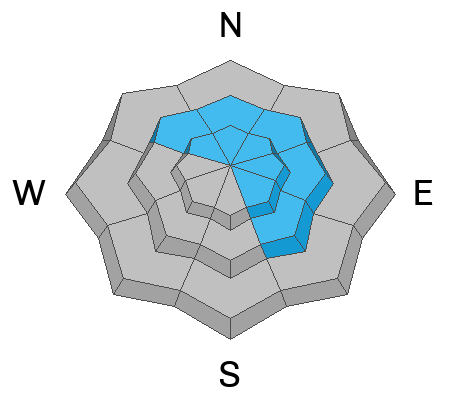
There is CONSIDERABLE danger in drifted terrain at upper and mid elevations on slopes facing northwest through southeast, where people are likely to large cornice falls and/or 1' to 2' thick slab avalanches of wind drifted snow. Heightened conditions exist and avalanches are possible on most other backcountry slopes steeper than 30°. Rain is falling on the saturated snow at lower elevations and loose wet avalanches are possible.

  • Conditions are dangerous in drifted terrain, so make conservative decisions, evaluate snow and terrain carefully, and stay well away from and out from under those big cornices.
Low
Moderate
Considerable
High
Extreme
Learn how to read the forecast here
Special Announcements
We are in the process of finalizing a report about the March 9th avalanche fatality in the Uintas. Thank you for your patience, and we will publish the final report in coming days.
Weather and Snow
Looks like more new snow in the southern part of the zone. The winds moderated a bit and a few inches of fresh snow is now covering up and hiding recent drifts and wind slabs that formed previously.
The 8400' Tony Grove Snotel reports 12 inches of new snow from the current storm. It's 23° F this morning, and there is 136 inches of total snow. The wind is blowing from the west around 20 mph at the 9700' CSI Logan Peak weather station.

Here is the NWS point forecast (36 hrs) for high elevations in the Central Bear River Range:
Today: Snow showers likely, mainly before 4pm. Cloudy, with a high near 28. West southwest wind 8 to 16 mph. Chance of precipitation is 70%. Total daytime snow accumulation of 2 to 4 inches possible.
Tonight: Snow showers likely, mainly after 1am. The snow could be heavy at times. Mostly cloudy, with a low around 16. Wind chill values as low as 4. Southwest wind 11 to 16 mph. Chance of precipitation is 70%. New snow accumulation of 3 to 7 inches possible.
Friday: Snow showers. The snow could be heavy at times. Areas of blowing snow after 1pm. Temperature falling to around 15 by 5pm. Wind chill values as low as -4. Blustery, with a northwest wind 11 to 16 mph increasing to 19 to 24 mph in the afternoon. Chance of precipitation is 100%. New snow accumulation of 8 to 12 inches possible.
Unsettled weather with snow showers in the mountains will continue through the weekend, and it looks like the sun will be out on Monday.
Recent Avalanches
  • Observers reported widespread shallow slab avalanches of storm snow Tuesday from across the zone including, Logan Dry and Wellsville and Mt. Naomi Wildeness.
  • For a list of recent avalanches in the Logan Zone go HERE
  • It was a bit more active in the Wasatch Range in the last few days due to wind drifted snow. Find a list of all recent observations & avalanches from across Utah HERE.
Ad
Avalanche Problem #1
Wind Drifted Snow
Type
Location
Likelihood
Size
Description
Today's moderate winds are blowing from the west, still plenty strong enough to drift the fresh snow into avalanche starting zones. Expect to find sensitive cornices and fresh wind slabs in upper and mid elevation avalanche starting zones. A few inches of fresh powder from this morning may be obscuring otherwise obvious recent drifts and wind slabs.
  • Large cornice falls, or 1 to 2' thick wind slabs, are likely for people to trigger in windy terrain at upper elevations.
  • Avoid corniced slopes and stiffer drifts on steep slopes near ridges and in and around terrain features like cliff bands, sub-ridges, mid-slope break-overs, and gully walls.
  • The overhanging cornices on the high ridges have become huge with recent storms, so continue to stay well away and out from under them.
  • People could trigger soft slab or loose avalanches of storm snow today even on sheltered slopes steeper than 30°.
  • Natural avalanches are possible and soft storm slabs most easily triggered during periods of heavy snowfall and/or drifting.
Avalanche Problem #2
Wet Snow
Type
Location
Likelihood
Size
Description
Natural wet avalanches are possible in steep terrain. Rain is falling on low elevation snow this morning.
  • The snow on lower elevation slopes is quite a bit deeper than it normally is this time of year, especially on shady forested slopes.
  • The snow is soft and saturated and could unexpectedly slide off very steep slopes onto trails or into the river.
Additional Information
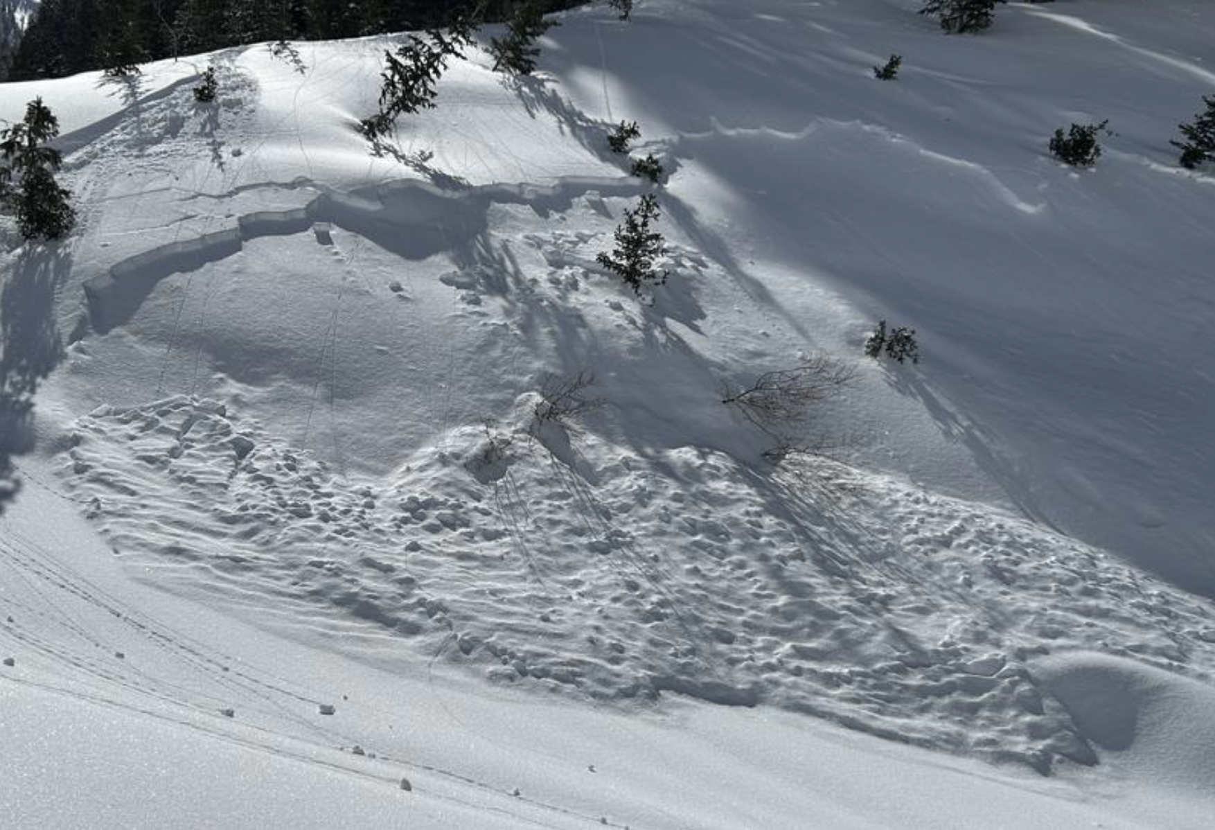
Small natural soft slab avalanches were widespread across the Logan Zone and in the Mount Naomi Wilderness Tuesday, 3-21-23...(R.Choi)
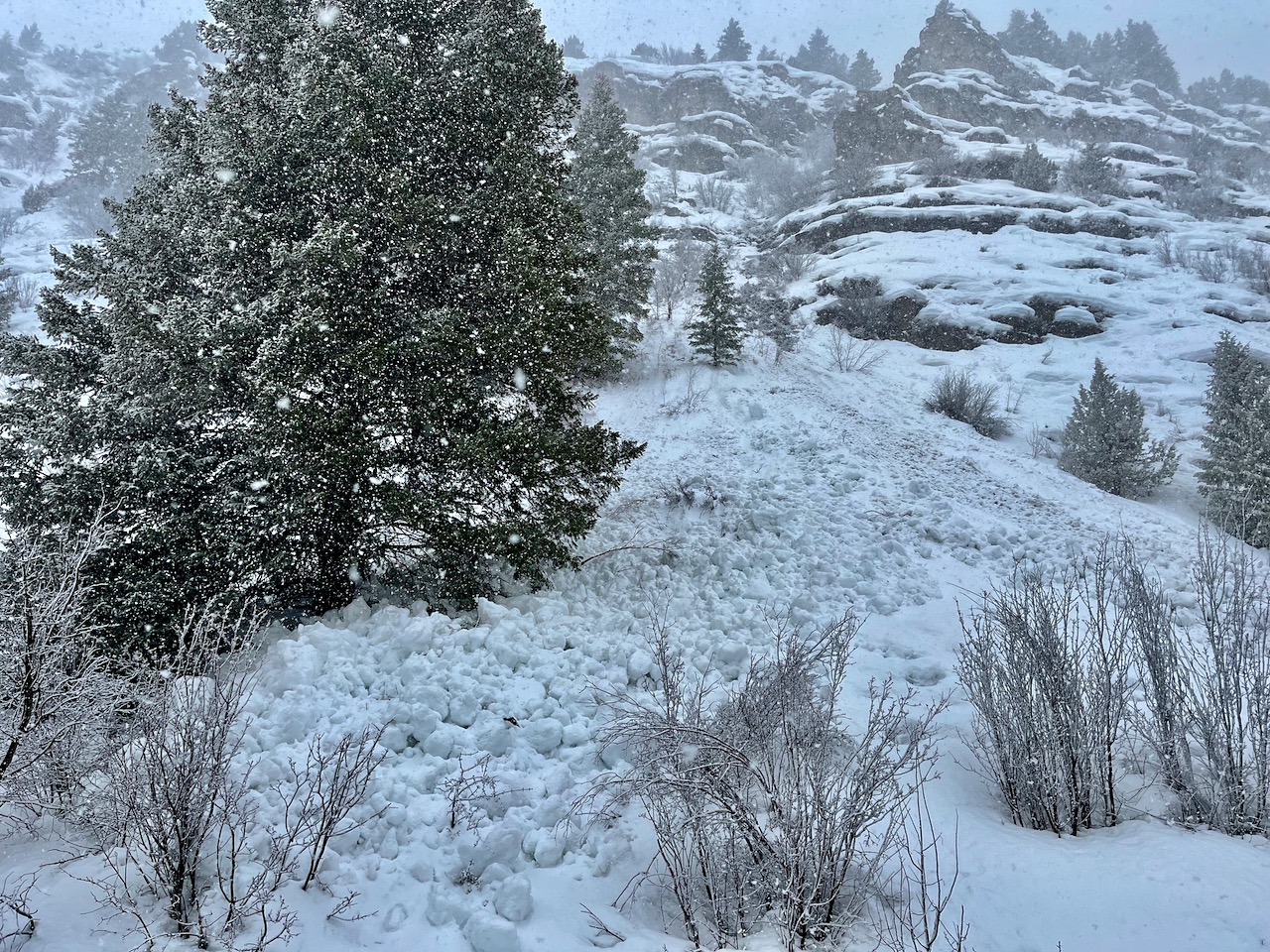
Very large natural wet avalanches occurred last week at lower elevations, some in unexpected places. This one is in Cowley Canyon, where an avalanche crossed the forest road, FR 047.
General Announcements
  • Please submit your observations from the backcountry HERE.
  • For a list of avalanche classes from the Utah Avalanche Center go HERE
  • For information on where you can ride your sled or snowbike, check out this map of the winter travel plan for the Logan and Ogden Ranger Districts HERE, and a close up of the Tony Grove and Franklin Basin Areas HERE.
This forecast is from the U.S.D.A. Forest Service, which is solely responsible for its content. This forecast describes general avalanche conditions and local variations always occur.