UDOT PLANNED AVALANCHE CLOSURES!!

Forecast for the Logan Area Mountains

Paige Pagnucco
Issued by Paige Pagnucco on
Saturday morning, March 22, 2025
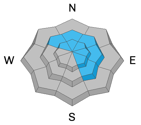
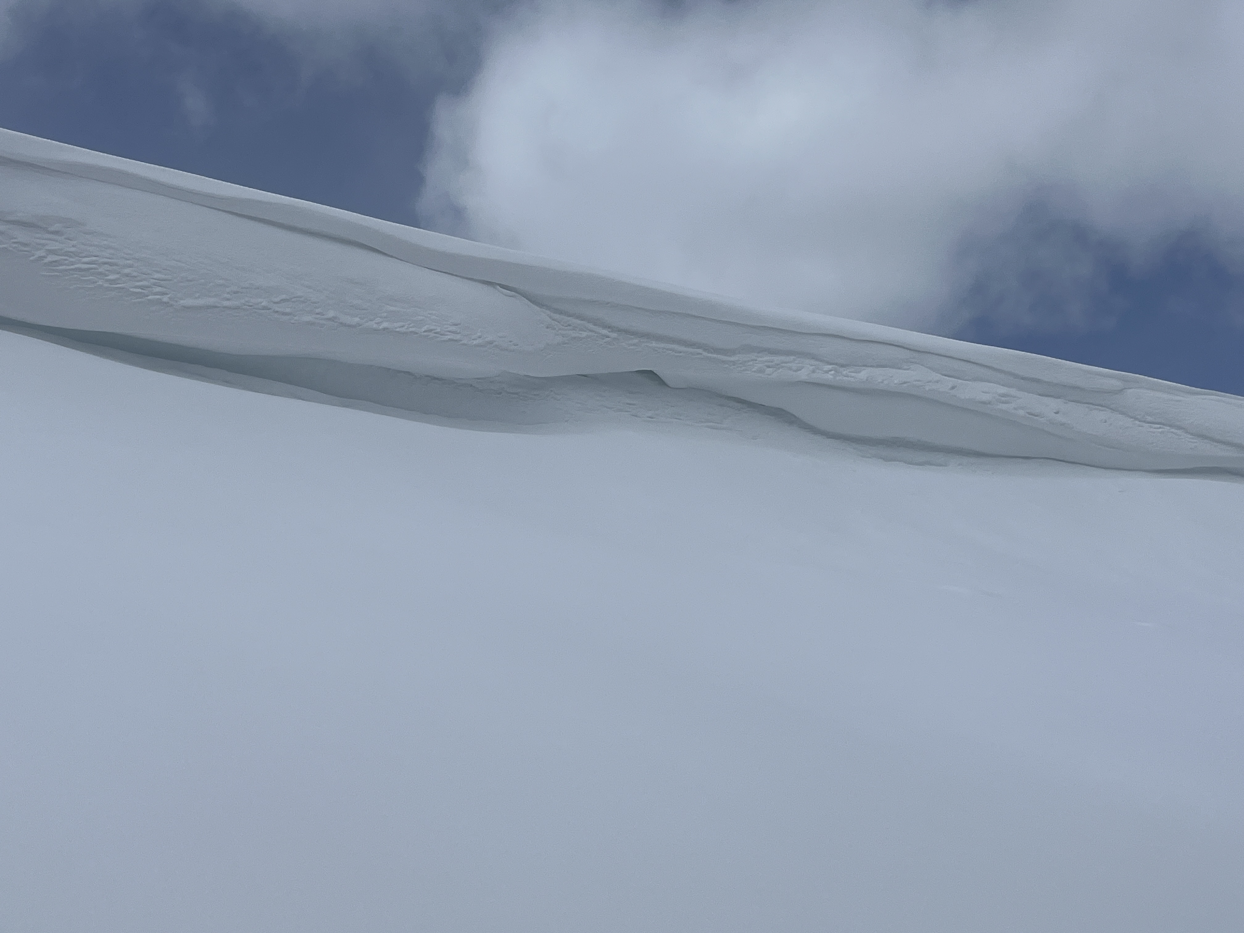
The avalanche danger is MODERATE today. Strong winds and heavy snowfall are creating heightened conditions and human-triggered avalanches are possible, mainly in upper-elevation wind-drifted terrain facing northwest through southeast. Avoid overhanging cornices as they could break further back than expected and possibly cause an avalanche on the slope below.
Evaluate the snow and terrain carefully. Stay well back from cornice edges and off of slopes under overhanging cornices.
If we get the high end or more of forecast snow amounts, the danger could rise to CONSIDERABLE.
Low
Moderate
Considerable
High
Extreme
Learn how to read the forecast here
Special Announcements
Our Spring Campaign is in full swing, and there are two great ways to support forecasting, awareness, and education across Utah:
Every dollar helps keep the backcountry community on top. Thank you for your support!"
Weather and Snow
Another winter storm for another bonus powder day! It's snowing in the mountains and the National Weather Service has issued a Winter Weather Advisory with heavy snowfall and strong winds expected for most of the day. Tony Grove picked up .4" of swe (3" of snow) overnight. There is great coverage in the Logan zone, and you'll find improving riding conditions throughout the day as snow accumulates. The biggest concern will be drifting by strong winds from the west. Avalanches of wind-drifted snow and large cornice falls are possible, mainly on slopes facing northwest through southeast. Mountain temperatures should stay below freezing, and hopefully, snowfall will continue throughout the day, though there is some uncertainty about total snow amounts. If we get the high end (10-14"), the avalanche danger may rise to CONSIDERABLE for a short period, but there is some sense that the storm is losing energy, and we may only see about 6-8" total.
*If the sun shines even briefly, it will moisten the snow surface and elevate the potential for loose wet (or moist) avalanches entraining recent snow on steep slopes.

The Tony Grove Snotel at 8400 feet reports 28°F this morning, with 102 inches of total snow (110% of normal SWE for the date). It's 24°F at the Card Canyon weather station at 8800 feet, with 79 inches of total snow. At 9700 feet at CSI's Logan Peak Wx station, winds are blowing 20 to 30 mph from the west with gusts in the 40s mph, and it's 22°F. The winds on Paris Peak at 9500 feet are blowing 17 to 27 mph from the west-southwest, and it's 21° F.

Today will be a stormy day in the mountains, with periods of heavy snowfall and sustained strong winds blowing from the west. 8500' high temperatures will be around 32°F. Winds will blow 20 to 30 mph, with gusts in the 40s mph. The uncertainty lies in how much snow the storm will produce; high-end forecast amounts (10-14") may push the avalanche danger into the considerable range at upper elevations making natural avalanches possible, but, the models are only showing about .6" total swe today, which is about 6-8" of snow. Just be mindful that during any period of high precipitation intensity, the avalanche danger is increasing. High pressure builds in tomorrow for most of the work week along with unseasonably warm temperatures.

For more information, visit the UAC weather page here: Weather - Utah Avalanche Center
For Logan-specific weather, go here: Logan Mountain Weather - Utah Avalanche Center
Recent Avalanches
An observer noted a small, shallow slab avalanche in Woodcamp yesterday. No other avalanches were reported.
Read about all avalanches and observations HERE.
Ad
Avalanche Problem #1
Wind Drifted Snow
Type
Location
Likelihood
Size
Description
Sustained winds from the west will build slabs of wind-drifted snow in exposed terrain. If you see snow pluming off ridges, that is a sign of wind loading.
  • Watch for and avoid stiffer wind-drifted snow on the lee side of major ridges, below cornices, and in and around terrain features like cliff bands, sub-ridges, and gully walls.
  • Wind slabs appear smooth, chalky, and rounded, and they can sound hollow, like a drum, when you move around on them.
  • Cracking is a red flag indicating unstable snow.
  • Hard wind slabs sometimes let you get out on them before releasing suddenly, while freshly formed, softer wind slabs are often very easily triggered, sometimes remotely (or from a distance).
  • High snowfall rates may cause loose dry avalanches on steep slopes.
Avalanche Problem #2
Cornice
Type
Location
Likelihood
Size
Description
  • People should stay off of, out from under, and well away from the edges of large overhanging cornices, which are deceptive and often break much further back than expected.
  • Natural and human-triggered cornice falls are possible today, and these could trigger avalanches on slopes beneath.
General Announcements
-National Forest Winter Recreation Travel Maps show where it's open to ride: UWCNF Logan, Ogden LRD Tony Grove, Franklin Basin CTNF Montpelier
-For all questions on forecasts, education, Know Before You Go, events, online purchases, or fundraising, call 801-365-5522.
-Remember the information you provide could save lives, especially if you see or trigger an avalanche. To report an avalanche or submit an observation from the backcountry, go HERE.
-Receive forecast region-specific text message alerts to receive messages about changing avalanche conditions, watches, and warnings. Sign up and update your preferences HERE.
-We are excited to announce the launch of our new mobile application available on both Android and IOS. Get all the information you need to plan your backcountry adventure and keep the information at the tip of your fingers while you are out. Install the Android version HERE and the IOS version HERE.

This forecast is from the U.S.D.A. Forest Service, which is solely responsible for its content. This forecast describes general avalanche conditions, and local variations always occur.