Forecast for the Logan Area Mountains

Toby Weed
Issued by Toby Weed for
Saturday, March 19, 2022
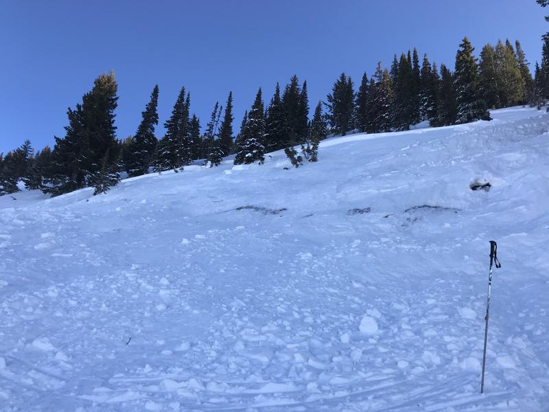
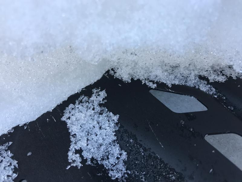
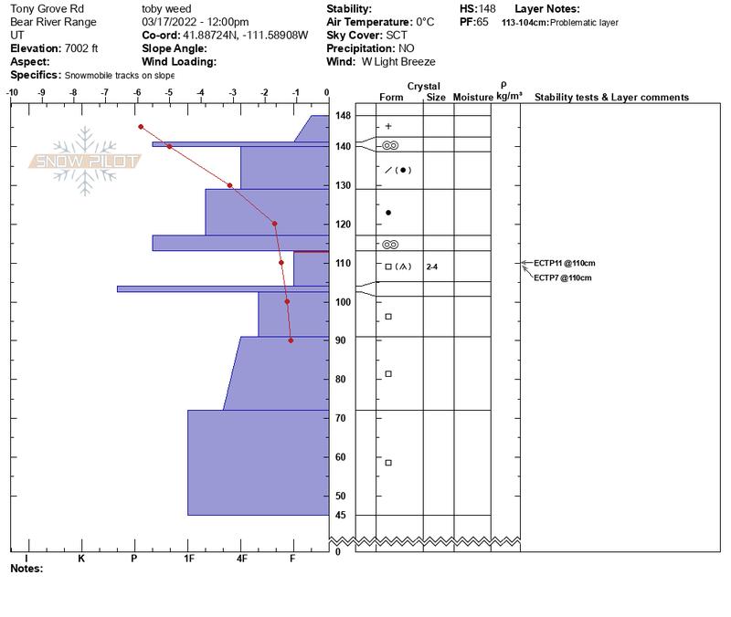
Heightened avalanche conditions exist in the backcountry, people could trigger dangerous avalanches, and the danger is MODERATE. While stability has improved on most slopes, elevated conditions persist in some areas with poor snow structure and unstable snow, which can be found in northerly facing terrain at all elevations. On slopes steeper than 30°, people could trigger dangerous slab avalanches, up to two feet deep and a couple hundred feet wide, failing on a buried persistent weak layer of faceted snow. Small loose wet avalanches are possible on steep slopes with saturated snow. Tomorrow, heavy snow and drifting will cause rising avalanche danger in the backcountry.
*Evaluate snow and terrain carefully, especially on north facing slopes in areas with poor snow structure.
Low
Moderate
Considerable
High
Extreme
Learn how to read the forecast here
Special Announcements
Please help support avalanche forecasting throughout Utah. Donate to the Spring Campaign to help raise the funds to support the forecasting you rely on...... HERE
Weather and Snow
Heightened avalanche conditions exist in the backcountry, and we're still finding buried layers of weak faceted snow on slopes at all elevations across the zone. Even so, snow stability appears to be pretty good in most places and you can find really nice riding conditions these days. Paige found very nice solid spring "corn" snow yesterday afternoon in sunny lower and mid elevation terrain in Logan Canyon. Unfortunately, pockets of unstable snow exist in some areas, mainly on northerly facing mid elevation slopes. Last week, heavy snow overloaded slopes with buried persistent weak layers consisting of sugary faceted snow, and additional accumulation and drifting this week added weight and depth to a developing slab layer. Although not widespread, dangerous avalanche conditions exist on isolated northerly facing slopes with this poor snow structure, and people might trigger dangerous avalanches today.


The 8400' Tony Grove Snotel reports 26°F, and here is 73 inches of total snow at the site, containing 84% of normal SWE for the date. The 9700' CSI Logan Peak weather station is still not updating, but the wind is blowing 10 to 15 mph out of the southwest on James Peak this morning. A spring storm with heavy snow and drifting from fairly strong south and westerly winds will cause rising avalanche danger in the backcountry tomorrow.

  • Today, expect partly sunny skies and breezy conditions, with high temperatures at 8500' around 43°F, and increasing 15 to 25 mph south-southwest winds.
  • Expect cloudy skies, blustery winds, and snow late tonight, with low temperatures holding around 26°F, and 20 to 25 mph south-southwest winds. An inch or two could accumulate on mountain slopes by tomorrow morning.
  • Snow is expected in the mountains tomorrow, with 4 to 8 inches of accumulation possible on upper elevation slopes. Temperatures will drop to around 23°F, and gusty, 15 to 25 mph west southwest winds with gusts near 40 mph will shift from the northwest in the afternoon.
  • Looks like fair spring weather with increasingly warm daytime temperatures next week.
Recent Avalanches
Last weekend and again early last week, people triggered a few sizable soft slab avalanches on the south side of Providence Canyon, where avalanche conditions remain rather sketchy. The avalanches above 8000' in elevation in north facing terrain failed on a very weak buried persistent weak layer of faceted snow. A few were triggered remotely, from a distance away. The largest was 12 to 20" deep, around 300' wide, and like the others, only ran a few hundred vertical feet.
One of several recent human triggered avalanches on the south side of Providence Canyon.

Check out all the recent backcountry observations and many recent avalanche reports from across Utah HERE
Ad
Avalanche Problem #1
Persistent Weak Layer
Type
Location
Likelihood
Size
Description
Last week's heavy snow created a cohesive and harder slab on widespread preexisting layers of very weak faceted snow. In some areas, the overload of heavy new snow was just enough to activate these layers and cause dangerous slab avalanches. More snow fell and drifting occurred earlier this week, which continued to load slopes with poor snow structure. On slopes facing the north half of the compass in some areas, people could trigger soft slab avalanches failing on a buried persistent weak layer. Although becoming less frequent, observers in the Logan Zone this week reported signs of instability in some areas, including audible collapsing and cracking.
  • In isolated areas, avalanches still might be triggered remotely or from a distance.
Very weak faceted snow is buried and preserved in many areas. Poor snow structure exists where a slab of harder snow sits above these buried layers of loose faceted snow, and in some areas, stability tests show unstable conditions.
Avalanche Problem #2
Wet Snow
Type
Location
Likelihood
Size
Description
Small loose avalanches of saturated surface snow are possible in steep terrain wherever seasonal heat saturates and softens the surface snow. Today, sheltered sunny slopes in steep rocky areas are the most suspect. People should move off and out from under very steep slopes with saturated snow in the heat of the day.
Additional Information
  • Now is a great time to practice your avalanche rescue skills. Thanks to the generous support of Northstar, the Franklin Basin Beacon Training Park is up and running. The park is located directly west of the parking lot and is open for anyone to use. All you need is your beacon and probe. Please do not dig up the transmitters.
  • Always follow safe backcountry travel protocols. Go one person at a time in avalanche terrain, while the rest of your party watches from a safe area. (practice anytime while traveling on or under backcountry slopes steeper than 30°)
  • Check your avalanche rescue equipment, change your batteries, and practice often with your backcountry partners.
    Check slope angles, and to avoid avalanche terrain stay off of and out from under slopes steeper than 30° and adjacent slopes. Video Here
General Announcements
Special thank you to Polaris and Northstar...Video Here
Who's up for some free avalanche training? Get a refresher, become better prepared for an upcoming avalanche class, or just boost your skills. Go to https://learn.kbyg.org/ and scroll down to Step 2 for a series of interactive online avalanche courses produced by the UAC.
  • Check out all the upcoming education classes and clinics HERE.
  • Please submit your observations from the backcountry HERE.
This information does not apply to developed ski areas or highways where avalanche control is normally done. This forecast is from the U.S.D.A. Forest Service, which is solely responsible for its content. This forecast describes general avalanche conditions and local variations always occur.