Donate to Our Spring Campaign or Bid on our Spring Auction to Support Forecasting

Forecast for the Logan Area Mountains

Toby Weed
Issued by Toby Weed on
Monday morning, March 17, 2025
The danger is CONSIDERABLE in the backcountry today, with dangerous avalanche conditions in drifted terrain. Natural cornice falls and large avalanches of wind-drifted snow are possible. People are likely to trigger wind slab avalanches up to 3 feet deep and 200 feet wide on drifted upper and mid-elevation slopes steeper than 30 degrees facing northwest through southeast. Small wet avalanches are possible in low and mid-elevation terrain as the day warms.
Make conservative choices and evaluate the snow and terrain carefully. Avoid steep, drifted slopes and stay well away from and out from under overhanging cornices.
Low
Moderate
Considerable
High
Extreme
Learn how to read the forecast here
Special Announcements
Our Spring Campaign is in full swing, and there are two great ways to support forecasting, awareness, and education across Utah:
Every dollar helps keep the backcountry community on top. Thank you for your support!"
Weather and Snow
You can find nice shallow powder riding conditions in upper-elevation terrain, but in most places, you can feel last week's crusty snow or old tracks beneath it. Clouds and wind kept the snow from becoming too moist yesterday, but we'll still probably find surface crusts at mid and lower elevations and on slopes hit for even a little while yesterday by the high-angle March sun. The best riding will be found on low-angled, shady slopes, and there is significantly more recent new snow in upper-elevation terrain.
Drifting by sustained and gusty winds from the southwest elevated the avalanche danger, and dangerous conditions exist on drifted upper and mid-elevation slopes. Large cornice falls are possible, and these could trigger wind slab avalanches on slopes below. Strong winds from the southwest are expected to continue today, and while weak layers at the old snow surface and within the storm snow should stabilize fairly quickly, human-triggered wind slab avalanches up to 3 feet deep are likely on drifted slopes steeper than 30°. Cloud cover and good ventilation from today's strong winds should keep a lid on wet avalanche activity. Still, daytime temperatures will be fairly warm, and the strong March sun might pop out from behind the clouds from time to time. Depending on how warm it gets, loose wet avalanches entraining moist storm snow are possible in steep low and mid-elevation terrain in the heat of the day.
The Tony Grove Snotel at 8400 feet reports a few inches of new snow in the past 24 hours and about 1.5 feet of new snow with 2.2" SWE in the past 4 days. It's 33° F, with 102 inches of total snow (110% of normal for the date). It's 31° F at the Card Canyon weather station at 8800 feet, with 75 inches of total snow. At 9700 feet at CSI's Logan Peak Wx station, winds are blowing 35 to 50 mph from the southwest, with a gust of 64 mph late last night, and it's 26° F. The winds on Paris Peak at 9500 feet are blowing 19 to 35 mph, with gusts around 40 mph from the south-southwest, and it's 24° F.

We'll get a break in the stormy weather today, but it will be rather warm and quite windy again. It will be mostly cloudy and breezy, with a high temperature at 8500 feet near 40° F, and winds from the west-southwest 23 to 26 mph, with gusts as high as 41 mph. Snow is possible in the afternoon, but not much accumulation is expected. The National Weather Service has issued a Winter Weather Advisory for the Logan Zone beginning at 6:00 tonight and extending through tomorrow evening. The wind will shift from the northwest, temperatures will drop to around 20° F, and snow will be heavy at times, with 13 to 21 inches of accumulation possible by tomorrow evening. The avalanche danger could rise to HIGH in the backcountry by tomorrow.

For more information, visit the UAC weather page here: Weather - Utah Avalanche Center
For Logan-specific weather, go here: Logan Mountain Weather - Utah Avalanche Center
Recent Avalanches
There were some good-sized natural avalanches during yesterday's wind storm, with a couple of large wind slab-cornice fall avalanches observed in the Mt Naomi Wilderness.
Read about all avalanches and observations HERE.
Ad
Avalanche Problem #1
Wind Drifted Snow
Type
Location
Likelihood
Size
Description
Winds are again the big story today. They are expected to blow fairly consistently from the southwest, around 20-30 mph, with gusts in the 40s mph. There is plenty of fresh snow to blow around, and hard and stiff wind slabs will continue to develop on the lee side of exposed ridges and around terrain features like cliff bands, sub-ridges, and gullies.
  • Watch for and avoid stiffer wind-drifted snow on the lee side of major ridges, below cornices, and in and around terrain features like cliff bands, sub-ridges, and gully walls.
  • Wind slabs appear smooth, chalky, and rounded, and they can sound hollow, like a drum, when you move around on them.
  • Cracking is a red flag indicating unstable snow.
  • Hard wind slabs sometimes let you get out on them before releasing suddenly. Freshly formed, softer wind slabs are often very easily triggered, sometimes remotely (or from a distance).
  • People should stay off of, out from under, and well away from large overhanging cornices, which are deceptive and often break much further back than expected. Natural cornice falls are possible, and these could trigger avalanches on slopes beneath.
Avalanche Problem #2
Wet Snow
Type
Location
Likelihood
Size
Description
Expect to see loose wet avalanches as the day warms, particularly on low-elevation slopes and possibly some mid-elevation slopes. Temperatures are already in the mid-40s this morning in Logan. It is mid-March, and the snow will become slushy and lose cohesion, especially if the sun comes out.
  • Rollerballs, pinwheels, and sluffs are sure signs of instability.
  • Move off of and out from under slopes holding saturated snow.
  • Avoid fishing in the Logan River beneath steep slopes with saturated snow.
Additional Information
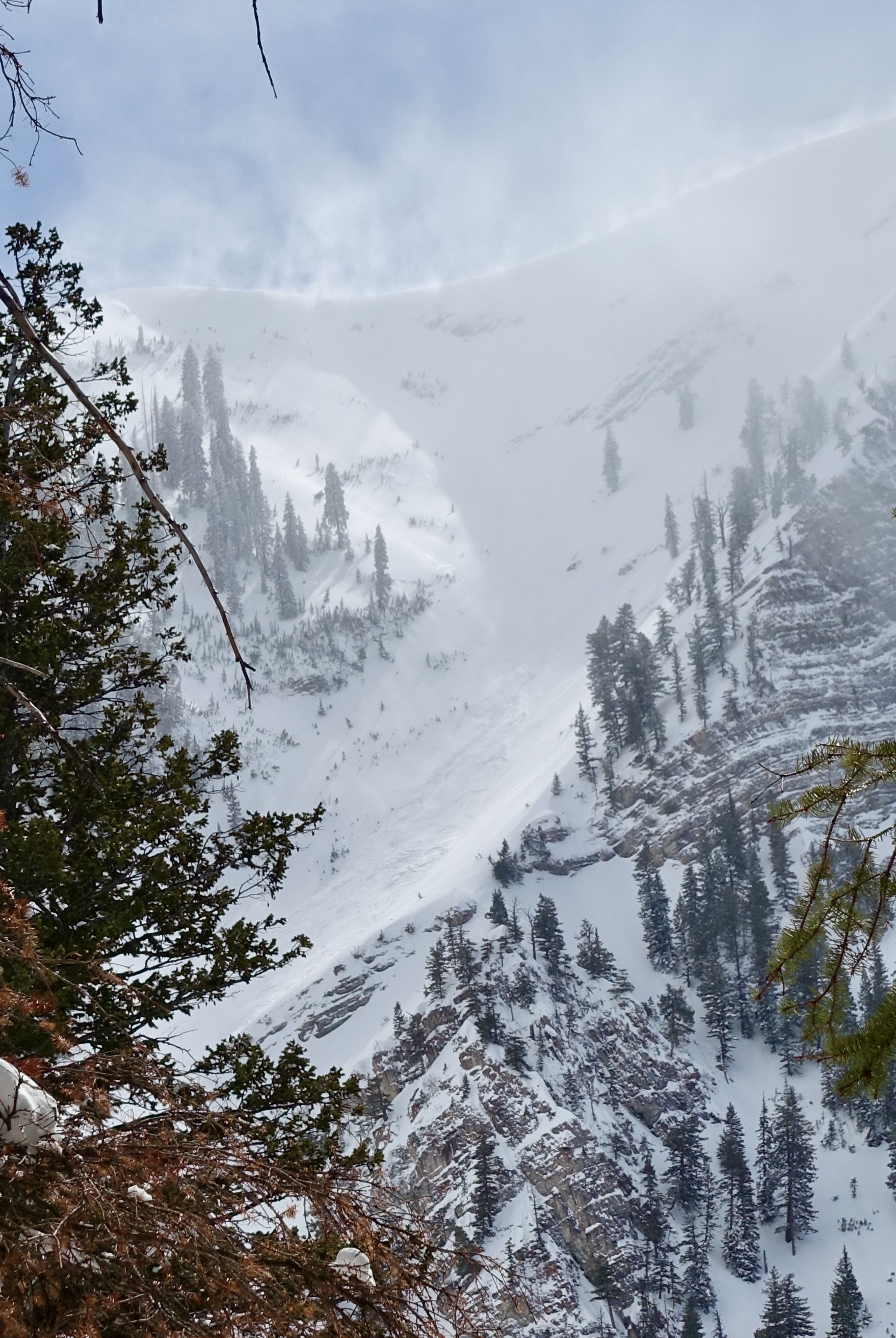
Yesterday, a long-running natural avalanche was observed in High Creek's Z-Gully off Cherry Peak in the Mount Naomi Wilderness. Report
General Announcements
-National Forest Winter Recreation Travel Maps show where it's open to ride: UWCNF Logan, Ogden LRD Tony Grove, Franklin Basin CTNF Montpelier
-For all questions on forecasts, education, Know Before You Go, events, online purchases, or fundraising, call 801-365-5522.
-Remember the information you provide could save lives, especially if you see or trigger an avalanche. To report an avalanche or submit an observation from the backcountry, go HERE.
-Receive forecast region-specific text message alerts to receive messages about changing avalanche conditions, watches, and warnings. Sign up and update your preferences HERE.
-We are excited to announce the launch of our new mobile application available on both Android and IOS. Get all the information you need to plan your backcountry adventure and keep the information at the tip of your fingers while you are out. Install the Android version HERE and the IOS version HERE.

This forecast is from the U.S.D.A. Forest Service, which is solely responsible for its content. This forecast describes general avalanche conditions, and local variations always occur.