Donate to Our Spring Campaign or Bid on our Spring Auction to Support Forecasting

Forecast for the Logan Area Mountains

Toby Weed
Issued by Toby Weed on
Tuesday morning, March 18, 2025
The danger is CONSIDERABLE in the backcountry today, with dangerous avalanche conditions on drifted upper and mid-elevation slopes steeper than 30 degrees. Natural cornice falls, avalanches of wind-drifted snow, and loose or soft slab avalanches of storm snow are possible. People are likely to trigger avalanches of storm snow, and wind slab avalanches up to 3 feet deep and 200 feet wide are possible.
  • Avoid steep, drifted slopes and stay well away from and out from under overhanging cornices.
  • Make conservative choices and evaluate the snow and terrain carefully.
Low
Moderate
Considerable
High
Extreme
Learn how to read the forecast here
Special Announcements
Our Spring Campaign is in full swing, and there are two great ways to support forecasting, awareness, and education across Utah:
Every dollar helps keep the backcountry community on top. Thank you for your support!"
Weather and Snow
Heavy snowfall is occurring this morning, visible on the Beaver Mt webcams. Periods of heavy snowfall and drifting by winds from the west-northwest will create dangerous avalanche conditions in upper and some mid-elevation terrain. Yesterday, we found nice powder riding conditions and deep, heavy snow from the weekend storms at upper elevations in the Tony Grove Area. Fresh powder from the storm last night and today will fill in yesterday's tracks and enhance riding conditions yet again. The new snow will come in on warm snow at low and mid-elevations, and it'll probably cap a surface met-freeze crust on many slopes.

The Tony Grove Snotel at 8400 feet reports 4 inches of new snow overnight with .4" SWE. It's 23° F, with 103 inches of total snow. It's 17° F at the Card Canyon weather station at 8800 feet, with 5.5 inches of new snow and 80 inches of total snow. At 9700 feet at CSI's Logan Peak Wx station, winds are blowing 20 to 30 mph from the west-northwest, and it's 15° F. The winds on Paris Peak at 9500 feet are blowing 19 to 28 mph from the northwest, and it's also 15° F.

The National Weather Service has continued a Winter Weather Advisory for the Logan Zone through this evening. Snowfall will be heavy at times this morning, mainly before noon, with 4 to 8 inches of additional accumulation possible in upper-elevation terrain. Expect a high temperature at 8500 feet around 22° F, and 22 to 24 mph winds blowing from the west-northwest, with gusts in the mid 40s. 2 to 4 additional inches of accumulation is possible tonight. Temperatures will drop to around 9° F, and 17 to 22 mph winds from the northwest will decrease to less than 15 mph after midnight. Tomorrow will be sunny with a high temperature near 27° F, with winds out of the west-southwest 6 to 11 mph.
The weather will remain unsettled through the weekend, with a few inches of accumulation likely on Thursday and periods of heavy snow possible again on Saturday.

For more information, visit the UAC weather page here: Weather - Utah Avalanche Center
For Logan-specific weather, go here: Logan Mountain Weather - Utah Avalanche Center
Recent Avalanches
There were some good-sized natural avalanches during Sunday's wind storm, with a couple of large cornice fall and/or wind slab avalanches observed in the Mt Naomi Wilderness. Yesterday, we could see that two large cornice fall avalanches occurred on Cornice Ridge. One of these was over 300' wide and ran at least 500 vrt' with very large debris chunks spread across the bowl.
Read about all avalanches and observations HERE.
Ad
Avalanche Problem #1
Wind Drifted Snow
Type
Location
Likelihood
Size
Description
  • Watch for and avoid stiffer wind-drifted snow on the lee side of major ridges, below cornices, and in and around terrain features like cliff bands, sub-ridges, and gully walls.
  • Wind slabs appear smooth, chalky, and rounded, and they can sound hollow, like a drum, when you move around on them.
  • Cracking is a red flag indicating unstable snow.
  • Hard wind slabs sometimes let you get out on them before releasing suddenly. (Hard wind slabs formed over the weekend may be hidden by a few inches of new snow today.)
  • Freshly formed, softer wind slabs are often very easily triggered, sometimes remotely (or from a distance).
  • People should stay off of, out from under, and well away from large overhanging cornices, which are deceptive and often break much further back than expected. Natural cornice falls are possible, and these could trigger avalanches on slopes beneath.
Avalanche Problem #2
New Snow
Type
Location
Likelihood
Size
Description
Human-triggered loose and soft slab avalanches of storm snow are likely on slopes with significant accumulations of new snow, especially where the new snow was drifted onto steep slopes. Natural avalanches of new snow are possible during periods of particularly heavy snowfall.
If the sun pops out even for a few minutes, it'll moisten the snow surface and increase the potential of loose wet (or moist) avalanches entraining storm snow.
Additional Information
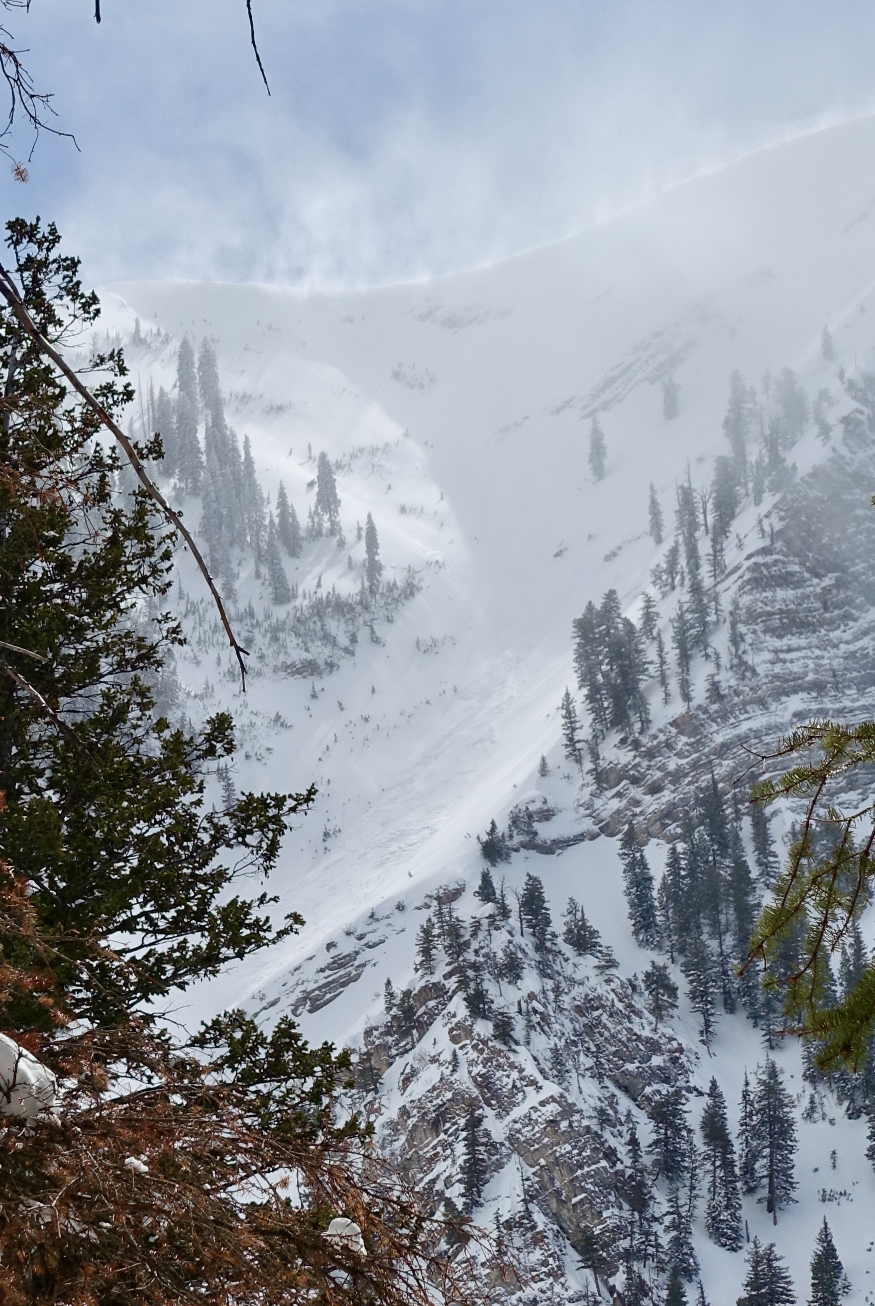
Sunday, a long-running natural avalanche was observed in High Creek's Z-Gully off Cherry Peak in the Mount Naomi Wilderness. Report
General Announcements
-National Forest Winter Recreation Travel Maps show where it's open to ride: UWCNF Logan, Ogden LRD Tony Grove, Franklin Basin CTNF Montpelier
-For all questions on forecasts, education, Know Before You Go, events, online purchases, or fundraising, call 801-365-5522.
-Remember the information you provide could save lives, especially if you see or trigger an avalanche. To report an avalanche or submit an observation from the backcountry, go HERE.
-Receive forecast region-specific text message alerts to receive messages about changing avalanche conditions, watches, and warnings. Sign up and update your preferences HERE.
-We are excited to announce the launch of our new mobile application available on both Android and IOS. Get all the information you need to plan your backcountry adventure and keep the information at the tip of your fingers while you are out. Install the Android version HERE and the IOS version HERE.

This forecast is from the U.S.D.A. Forest Service, which is solely responsible for its content. This forecast describes general avalanche conditions, and local variations always occur.