Forecast for the Logan Area Mountains

Toby Weed
Issued by Toby Weed on
Friday morning, March 13, 2026

MODERATE: The avalanche danger is LOW this morning, but skyrocketing mountain temperatures will elevate the risk of wet avalanches during the day in sunny terrain.

Evaluate the snow and terrain carefully.

Low
Moderate
Considerable
High
Extreme
Learn how to read the forecast here
Weather and Snow

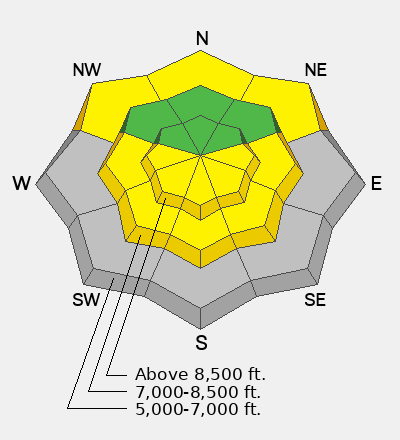
Spring is here, and the best plan for safe backcountry travel this time of year is to get an early start and to get off the snow before it gets too soft. You'll find nice, supportable spring-like corn snow, especially on lower-angle, sunny slopes where saturated surface snow has superficially refrozen and will quickly soften during the day. Incessant warm winds, like a giant blow dryer, are quickly melting the snow, with many slopes below 7000 feet already bare of snow. Heightened avalanche conditions will rapidly develop up higher as abnormally warm mountain temperatures and hot sun soften the snow surface. Wet avalanches entraining saturated snow will become increasingly possible. It's still possible in outlying rocky terrain for a person to trigger a destructive hard slab avalanche that fails on a persistent weak layer buried two to four feet deep, and a smaller wet avalanche overrunning a slope with poor snow structure could cause a much larger slide.

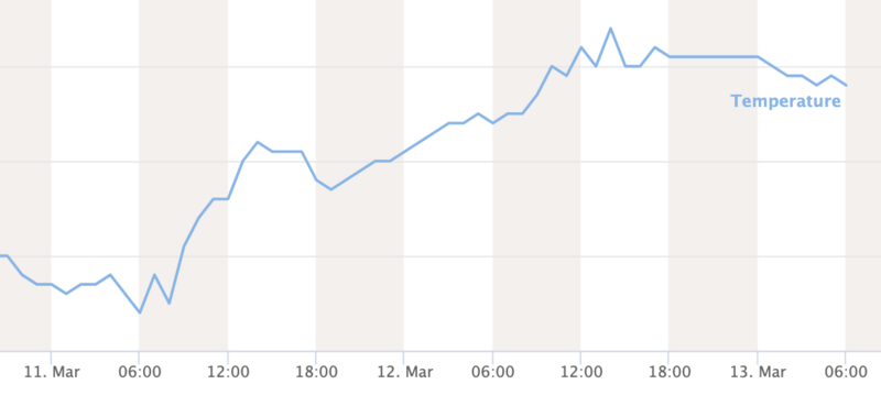
The UAC Card Canyon weather station at 8700 feet reports 34°F and 59 inches of total snow. The Tony Grove Snotel, at 8400 feet, reports 38°F with 70 inches of total snow. At 9700 feet on Logan Peak, winds are blowing from the west this morning, 25 to 35 mph, with overnight gusts above 50 mph. Strong winds continue to blow from the southwest on Paris Peak at 9500 feet, blowing 30 to 42 mph at this hour, and it's 29°F.

Expect partly sunny skies today, with temperatures climbing to around 42°F at the highest elevations, and blow dryer winds continuing from the west with gusts in the 50+ mph range. Tonight, clouds will increase, winds from the west will decrease, and temperatures will drop to around 34°F. Snow is likely up high tomorrow, with 2 to 4 inches of accumulation possible. Some thunder is also possible in the early afternoon. Expect temperatures to drop to around 32°F at around 8500', and the wind to increase again, continuing to blow from the west-southwest, with gusts pushing 50 mph. Snowfall will continue Saturday night, with another inch or so possible, and winds from the west will increase another notch. Temperatures in the mountains are expected to rise significantly next week, with record-breaking 60°F+ readings possible at upper elevations...

Recent Avalanches

Find observations in the Logan zone and from across the state HERE.

Avalanche Problem #1
Wet Snow
Type
Location
Likelihood
Size
Description

The hot March sun and greenhousing by increasing clouds this afternoon will quickly soften surface crusts, and loose wet avalanches entraining saturated surface snow will become increasingly possible in steep sunny terrain sheltered from southwest winds... As abnormally warm temperatures persist over the next few days and nighttime temperatures remain above freezing, the risk of both wet loose and more dangerous wet slab avalanches will increase.

  • Loose wet avalanches overrunning a slope with poor snow structure could cause the slide to step down into the buried January persistent weak layer, producing larger and more dangerous avalanches, several feet deep.

At Tony Grove, temperatures are well above freezing this morning.

Avalanche Problem #2
Persistent Weak Layer
Type
Location
Likelihood
Size
Description

A persistent weak layer of faceted snow from January is now buried about 2–4 ft deep on mid- and upper-elevation slopes facing the north half of the compass. While avalanches breaking into this layer are unlikely, any that do occur will be large, destructive, and dangerous.

  • While unlikely, avalanches failing on buried facets can propagate widely and may be triggered remotely—from the side or below.
  • Slopes with a shallower overall snowpack are most suspect. Avoid outlying rocky or wind-swept slopes at upper elevations, where snow is generally shallow. Deep hard slab avalanches can be triggered where the slab is thinner.
  • Smaller avalanches overrunning a slope with poor snow structure could step down to the layer and create a much larger avalanche.
Additional Information
  • Travel with a partner, and cross or ride slopes steeper than 30 degrees one at a time while the rest of your group watches from a safe spot.
  • Ensure that everyone in the group has avalanche rescue equipment (a transceiver, probe, and shovel) and knows how to use it.

-----------------------------------------------------------------------------------------------------------------------------------------------------------------

Join the UAC for the first "Stay and Play Avalanche Course" at Bear River Lodge in the Uintas, March 19th-22nd. This course is designed for snowmobilers by snowmobilers, where you will learn avalanche rescue, riding skills, and how to survive in the backcountry. Come enjoy all the luxury offerings at Bear River Lodge and improve your skills along the way.

For all questions on forecasts, education, Know Before You Go, events, online purchases, or fundraising, call 801-365-5522.

Did you know the UAC hosts a podcast? Episode 2 of Season IX is just out - AI, Machine Learning, and the Value of Expert Intuition at the Utah Avalanche Center.

Are you interested in learning more about avalanches? Visit our education page for details on all our classes.

For more information, visit the UAC weather page here: UAC Weather Page For Logan-specific weather, go here: Logan Mountain Weather

-Remember, the information you provide could save lives, especially if you see or trigger an avalanche. To report an avalanche or submit an observation from the backcountry, go HERE

-Receive forecast region-specific text message alerts to receive messages about changing avalanche conditions, watches, and warnings. Sign up and update your preferences HERE

This forecast is from the U.S.D.A. Forest Service, which is solely responsible for its content. This forecast describes general avalanche conditions and local variations always occur.

General Announcements
This information does not apply to developed ski areas or highways where avalanche control is normally done. This forecast is from the U.S.D.A. Forest Service, which is solely responsible for its content. This forecast describes general avalanche conditions and local variations always occur.