Forecast for the Logan Area Mountains

Toby Weed
Issued by Toby Weed for
Sunday, March 13, 2022
Heavy snow and drifting will cause rising avalanche danger in the backcountry today. Dangerous avalanche conditions and CONSIDERABLE danger exist at upper elevations and on mid elevation slopes facing northwest through southeast. People are likely trigger dangerous 1 to 2 foot deep slab avalanches failing on a buried persistent weak layer of faceted snow. Human triggered wind slab avalanches and loose avalanches of storm snow are possible on steep slopes at all elevations, and loose wet avalanches are possible on lower elevation slopes if rain saturates the snow today.
  • Continue to avoid and stay out from under drifted slopes steeper than 30°, especially those facing the north half of the compass.
  • Careful snowpack evaluation, cautious route-finding, and conservative decision making are essential.
Low
Moderate
Considerable
High
Extreme
Learn how to read the forecast here
Special Announcements
Thanks to the generous support of our local resorts and Ski Utah, discount lift tickets are now available. Support the UAC while you ski at the resorts this season. Tickets are available HERE.
Weather and Snow
Snow is already falling at Beaver Mountain this morning. Heavy snow up high, a chance of rain down low, and blowing snow are expected today, and will cause rising avalanche danger in the backcountry. During the week, copious heavy snow and drifting from fairly strong west winds overloaded slopes with buried persistent weak layers consisting of sugary faceted snow. Natural avalanches were common across the Logan Zone during the storm, dangerous avalanche conditions persist on many slopes, and people could still trigger dangerous avalanches today if they venture into steep terrain.

Snowfall is visible on Beaver Mountains Webcams this morning. The 8400' Tony Grove Snotel reports 34°F, and there is six feet (72 inches) of total snow at the site. Winds out of the south increased overnight and are blowing about 35 mph with gusts in the 50s this morning at the 9700' CSI Logan Peak weather station.

  • It will be rather stormy today in the mountains. Expect high temperatures at 8500' around 28°F, with continuing 25 to 30 mph winds, veering from the west. 6 to 10 inches of accumulation is possible on upper elevation slopes today.
  • Expect mostly cloudy skies tonight, with 1 or 2 inches of additional accumulation, low temperatures around 14°F, and continuing blustery 14 to 22 mph west winds.
  • It'll be nice and sunny tomorrow, with high temperatures around 32°F and 10 to 15 mph west winds.
  • Unsettled spring-like weather is expected this week, with the next chance for a few inches of snow around Tuesday night.
Recent Avalanches
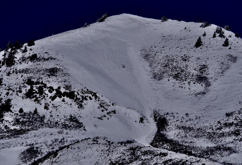
  • Yesterday, skiers triggered a couple sizable soft slab avalanches on the Millville Face in Providence Canyon. The avalanches at around 8600' in elevation on a north facing slope failed on a sugary persistent weak layer. The largest was 12 to 20" deep and around 300' wide.
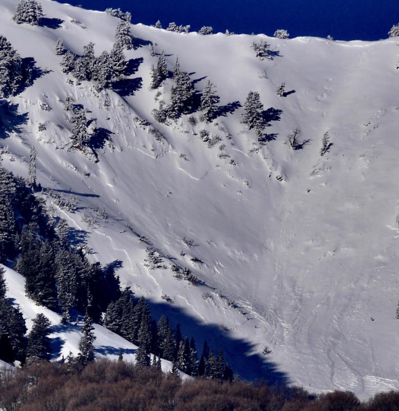
  • Friday afternoon, a skier was caught and carried around 200' by an avalanche on a southeast facing slope at around 8000' in Rattlesnake Canyon in the Wellsville Mountain Wilderness
  • Riders triggered several wind slab avalanches, some remotely, in the Central Bear River Range Thursday and Friday.
  • Natural avalanches were common in the Logan Zone during this week's storm, with evidence of some fairly large avalanches visible Thursday with clearing.
  • Parties in the Logan Zone continue to report signs of instability in the backcountry, including audible collapsing and cracking in some areas.
The skier who triggered this avalanche yesterday was going so fast they did not even know they had triggered the avalanche until down on the flats at the pick up zone.
A skier was caught and carried around 200' late Friday afternoon by this avalanche in upper Rattlesnake Canyon in the Wellsville Mountain Wilderness.
With clearing on Thursday, we observed lots of natural activity including a couple good sized natural avalanches in the Wellsville Mountain Wilderness, which were quite visible from Cache Valley.
Check out all the recent backcountry observations and many recent avalanche reports from across Utah HERE
Ad
Avalanche Problem #1
Persistent Weak Layer
Type
Location
Likelihood
Size
Description
Last week's fresh snow created a more cohesive slab on widespread preexisting layers of very weak faceted snow. In many areas the overload of heavy new snow was just enough to activate these layers and cause dangerous slab avalanches. On slopes facing the north half of the compass, people are likely to trigger soft slab avalanches failing on a buried persistent weak layer. Persistent weak layers consisting of faceted snow sandwiched between crusts exist in some more sunny terrain, and some may be becoming active now as they are overloaded by drifted snow. Red flags of snow instability are apparent in the backcountry, avalanches have been observed locally, and we've received reports of extensive audible collapses and cracking.
  • Avalanches could be triggered remotely or from a distance.
  • Collapsing and cracking are red flags indicating unstable snow and a persistent weak layer.
Avalanche Problem #2
Wind Drifted Snow
Type
Location
Likelihood
Size
Description
South winds increased overnight, and there is still some soft snow at upper elevations to drift about. Last weeks west winds were plenty strong enough to create significant drifts and sensitive soft slabs up to a couple feet deep, and south and west winds will continue to drift snow today. Drifting is overloading slopes with buried persistent weak layers and increasing the depth and weight of a developing slab layer. Avalanches of wind drifted snow are most likely today at upper elevations on northwest through southeast facing slopes.
  • Avoid fresh drifts on the lee side of major ridges and in and around terrain features like around and below cliff bands, gully walls, and sub-ridges.
Avalanche Problem #3
New Snow
Type
Location
Likelihood
Size
Description
  • As new snow piles up on steep mountain slopes today soft slab avalanches will become possible for people to trigger, and natural avalanches may occur during periods of particularly heavy snowfall.
  • Loose dry avalanches (or sluffs) of fresh snow are possible in sheltered terrain on very steep slopes at all elevations.
  • Rain on the snow at lower elevations today could saturate the recent snow and create a danger of loose wet avalanches. On sustained slopes, loose wet avalanches could pile up deeply, especially in terrain traps like gullies, sinks, and benches.
  • Manage loose avalanches by staying out of constricting terrain, like drainage gullies, and moving out of the fall line so you don't get caught by your own sluff.
  • Avoid being caught and pulled into terrain traps below you like trees, gullies, sinks, or benches.
Additional Information
  • Now is a great time to practice your avalanche rescue skills. Thanks to the generous support of Northstar, the Franklin Basin Beacon Training Park is up and running. The park is located directly west of the parking lot and is open for anyone to use. All you need is your beacon and probe. Please do not dig up the transmitters.
  • Always follow safe backcountry travel protocols. Go one person at a time in avalanche terrain, while the rest of your party watches from a safe area. (practice anytime while traveling on or under backcountry slopes steeper than 30°)
  • Check your avalanche rescue equipment, change your batteries, and practice often with your backcountry partners.
    Check slope angles, and to avoid avalanche terrain stay off of and out from under slopes steeper than 30° and adjacent slopes. Video Here
General Announcements
Special thank you to Polaris and Northstar...Video Here
Who's up for some free avalanche training? Get a refresher, become better prepared for an upcoming avalanche class, or just boost your skills. Go to https://learn.kbyg.org/ and scroll down to Step 2 for a series of interactive online avalanche courses produced by the UAC.
  • Check out all the upcoming education classes and clinics HERE.
  • Please submit your observations from the backcountry HERE.
This information does not apply to developed ski areas or highways where avalanche control is normally done. This forecast is from the U.S.D.A. Forest Service, which is solely responsible for its content. This forecast describes general avalanche conditions and local variations always occur.