Check out our Holiday Auction - Sign Up for the Utah Snow and Avalanche Workshop (USAW)

Forecast for the Logan Area Mountains

Toby Weed
Issued by Toby Weed on
Thursday morning, February 8, 2024
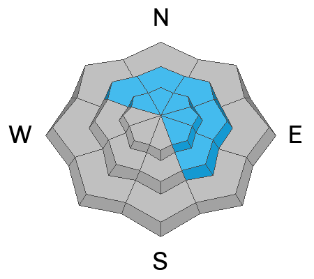
Elevated avalanche conditions exist on slopes steeper than 30° at all elevations. Areas with CONSIDERABLE danger may be found in drifted upper-elevation terrain on slopes facing northwest through southeast, where people could likely trigger avalanches of wind-drifted snow, and natural avalanches are possible. The probability of triggering a dangerous avalanche failing on a buried persistent weak layer is low but not zero in outlying recently drifted rocky terrain with shallow snow cover.
Careful snowpack evaluation, cautious route-finding, and conservative decision-making are essential for safe travel in the backcountry.
Low
Moderate
Considerable
High
Extreme
Learn how to read the forecast here
Special Announcements
Want to learn more about how to stay safe from avalanches while riding in the backcountry? Join us Feb 23-24 for an Introduction to Avalanche class. Information and registration here.
Weather and Snow
The backcountry avalanche danger is not as high as it is in areas to our south because we received much less new snow this week. Very nice shallow, fast, and fun powder conditions are found in many areas. Safer lower-angled slopes (less steep than 30°) offer the best riding due to a solid crust formed during last week's warm spell. The fresh snow is not super light, but it has substance and keeps you off the scratchy crust unless you're riding in steeper terrain.
People could trigger slab avalanches of drifted new snow on slopes steeper than 30° at all elevations. Still, wind slab avalanches are most likely on upper elevation slopes facing northwest through southeast. Dangerous hard slab avalanches failing on a deeply buried persistent weak layer are unlikely yet possible in outlying rocky terrain with shallow snow cover.

The wind is blowing from the west-southwest this morning 15 to 20 mph at the 9700' CSI Logan Peak weather station, where it's 15° F. On Paris Peak at 9500', it’s 14° F, and the wind is blowing 10 mph with gusts around 20 mph from the west-southwest. The Tony Grove Snotel at 8400' reports 21° F and maybe an inch of new snow overnight. The station reports 82 inches of total snow, containing 123% of average SWE (Snow Water Equivalent).

Snow is likely this afternoon, with less than an inch of accumulation likely. Skies will be mostly cloudy, with a high temperature around 27° F at 8500'. The wind will blow from the west 10 to 13 mph. Snow is likely tomorrow afternoon, with 1 to 3 inches of accumulation possible. High temperatures are expected to be near 23° F, with winds from the west-southwest blowing 7 to 13 mph. It looks like we'll see pretty nice weather this weekend, with some sunshine and colder temperatures that should keep the snow quality good.
Recent Avalanches
No avalanches have been reported recently, but we noticed some fresh wet avalanche activity at lower elevations in Providence Canyon on Tuesday. Also, on Tuesday, one party observed collapsing at upper elevations in the Franklin Basin Area. Audible collapsing (or whumpfs) is a red flag indicating unstable snow.
Check out local observations and avalanches HERE.
Ad
Avalanche Problem #1
Wind Drifted Snow
Type
Location
Likelihood
Size
Description
Avoid recent drifts or wind slabs on steep slopes. Drifting of this week's fresh snow by strong south and west winds created wind slabs on the lee side of major ridges and in and around terrain features like sub ridges, gully walls, mid-slope roll-overs, and under cliff bands. People could trigger wind slab avalanches on steep drifted slopes at all elevations, but most likely on upper elevation slopes facing northwest through southeast.
  • Even small avalanches of wind-drifted snow could run fast and far on the slick crust formed during last week's warm temperatures.
  • Wind slabs are made up of stiffer or heavier snow that may be more supportable than the surrounding powder. Lense-shaped drifts often make hollow, drum-like sounds.
  • Cracking is an obvious sign of wind slab instability. But, avalanches may still occur when no instability red flags are apparent.
  • Soft slab and loose avalanches of new snow are possible in more sheltered terrain on slopes steeper than 30° at all elevations.

Avalanche Problem #2
Persistent Weak Layer
Type
Location
Likelihood
Size
Description
In some outlying areas, a buried persistent weak layer of sugary snow from the December dry spell may be reawakened by this week's load of drifted new snow. The probability is low, but not zero, and potential hard slab avalanches could be large and life-threatening.
  • Avalanches failing on a persistent weak layer may be possible in recently drifted outlying rocky or windswept areas with generally shallow snow cover.
  • Collapsing or whumpfs are obvious signs of instability, but these red flags may not be present when deep hard slab avalanches failing on a persistent weak layer occur.
  • It's a good idea to get your shovel out and dig into the snow to identify areas with poor snow structure before you commit to steeper objectives. Another trick is to probe for areas with shallower snow cover that may harbor buried persistent weak layers.

Additional Information
On Sunday, we checked out the deposition from multiple large avalanches that occurred in January in Woodcamp. Though not historical in size, these slides laid out some pretty impressive debris piles.
General Announcements

-Read Toby's recent blog about wind, drifting, and avalanches HERE
-Sign up for forecast region-specific text message alerts. You will receive messages about changing avalanche conditions, watches, and warnings...HERE.
-For all questions on forecasts, education, Know Before You Go, events, online purchases, or fundraising, call 801-365-5522.
-To report an avalanche or submit an observation from the backcountry, go HERE.
-Come practice companion rescue at the Franklin Basin TH Beacon Training Park. It's free and open to everyone. For easy user instructions, go HERE
-We will update this forecast by 7:30 AM tomorrow.
This forecast is from the U.S.D.A. Forest Service, which is solely responsible for its content. This forecast describes general avalanche conditions, and local variations always occur.