Forecast for the Logan Area Mountains

Toby Weed
Issued by Toby Weed for
Wednesday, February 7, 2024
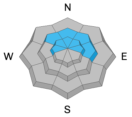
Elevated avalanche conditions exist on slopes steeper than 30°at all elevations, and heavy snowfall and drifting will cause rising danger today.
The danger is CONSIDERABLE in drifted upper-elevation terrain where natural avalanches are possible. People could easily trigger avalanches of wind-drifted snow, mainly on slopes facing the north half of the compass. Dangerous avalanches failing on a buried persistent weak layer are unlikely yet possible in recently drifted isolated or outlying rocky terrain with shallow snow cover. Loose wet avalanches are possible on steep lower-elevation slopes.

Careful snowpack evaluation, cautious route-finding, and conservative decision-making are essential for safe travel. Avoid and stay out from under drifted slopes steeper than 30°
Low
Moderate
Considerable
High
Extreme
Learn how to read the forecast here
Special Announcements
Want to learn more about how to stay safe from avalanches while riding in the backcountry? Join us Feb 23-24 for an Introduction to Avalanche class. Information and registration here.
Weather and Snow
The mountains picked up about 4" of new, heavy snow overnight, and winds blowing from the south-southwest continued to drift snow into lee terrain. Yesterday we found deeper-than-expected new snow in northerly-facing terrain, with the best conditions on sheltered lower-angled slopes.
Heavy snow, rain down low, and drifting by westerly winds will cause the avalanche danger to rise today. People could trigger slab avalanches of drifted new snow on upper and mid-elevation slopes steeper than 30°. Dangerous hard slab avalanches failing on a deeply buried persistent weak layer are unlikely yet possible in outlying rocky terrain with shallow snow cover. People may trigger wet avalanches on steep slopes with saturated snow at low elevations.

The wind is blowing from the south-southwest this morning at around 25 mph, with overnight gusts up to 64 mph at the 9700' CSI Logan Peak weather station, where it's 23° F. On Paris Peak at 9500', it’s 24° F, and the wind is blowing 5 to 10 mph with gusts around 20 mph from the south-southwest. The Tony Grove Snotel at 8400' reports 29° F and 4 inches of new snow overnight with .4" SWE. The station reports 82 inches of total snow, containing 120% of average SWE (Snow Water Equivalent).

Today, snow could be heavy at times in the mountains and 4 to 8 inches of accumulation is possible. High temperatures at 8500' are expected to reach 31° F. The wind is expected to come around from the west-northwest and blow 17-23 mph. Snow is likely to continue tonight, with 1 to 3 additional inches of accumulation possible. Temperatures will drop throughout the remainder of the week, with high temperatures in the 20's F and lows in the single digits by Thursday night and into the weekend.
Recent Avalanches
No avalanches were reported yesterday, but we noticed some fresh wet avalanche activity at lower elevations in Providence Canyon. One party observed collapsing at upper elevations in the Franklin Basin Area. Audible collapsing (or whumpfs) is a red flag indicating unstable snow.
Check out local observations and avalanches HERE.
Ad
Avalanche Problem #1
Wind Drifted Snow
Type
Location
Likelihood
Size
Description
Drifting of the new snow by strong southerly winds created wind slabs on the lee side of major ridges and in and around terrain features like sub ridges, gully walls, mid-slope roll-overs, and under cliff bands. People could trigger wind slab avalanches on steep slopes, mainly on the north half of the compass. Even small avalanches of stiffer, wind-drifted snow could run fast and far on the slick crust formed during last week's warm temperatures.
  • Avoid recent drifts or wind slabs on steep slopes. Wind slabs are made up of stiffer snow that may be more supportable than the surrounding powder. Lense-shaped drifts often make hollow, drum-like sounds.
  • Cracking is an obvious sign of wind slab instability.
  • Soft slab avalanches of new snow are possible on slopes steeper than 30° at all elevations.

Although unlikely, hard slab avalanches failing on a buried persistent weak layer may be reawakened by a load of drifted new snow, and these avalanches could be large and life-threatening. Avalanches failing on a persistent weak layer are possible in recently drifted outlying rocky or windswept areas with generally shallow snow cover. Collapsing or whumpfs are obvious signs of instability, but these red flags may not be present when deep hard slab avalanches occur.
  • It's a good idea to get your shovel out and dig into the snow to identify areas with poor snow structure before you commit to steeper objectives.
Avalanche Problem #2
Wet Snow
Type
Location
Likelihood
Size
Description
Rain saturated the low-elevation snowpack, and you may encounter potential for wet snow avalanches on steep slopes.
  • If you sink deeply into the saturated snow, move to a cooler aspect or elevation.
  • Roller balls, pinwheels, and suffs of saturated snow indicate potential for wet avalanche activity.

We found conditions indicating wet avalanche potential in lower Providence Canyon yesterday afternoon.

Additional Information
On Sunday, we checked out the deposition from multiple large avalanches that occurred in January in Woodcamp. Though not historical in size, these slides laid out some pretty impressive debris piles.
General Announcements

-Read Toby's recent blog about wind, drifting, and avalanches HERE
-Sign up for forecast region-specific text message alerts. You will receive messages about changing avalanche conditions, watches, and warnings...HERE.
-For all questions on forecasts, education, Know Before You Go, events, online purchases, or fundraising, call 801-365-5522.
-To report an avalanche or submit an observation from the backcountry, go HERE.
-Come practice companion rescue at the Franklin Basin TH Beacon Training Park. It's free and open to everyone. For easy user instructions, go HERE
-We will update this forecast by 7:30 AM tomorrow.
This forecast is from the U.S.D.A. Forest Service, which is solely responsible for its content. This forecast describes general avalanche conditions, and local variations always occur.