Forecast for the Logan Area Mountains

Issued by Toby Weed on
Thursday morning, February 6, 2020
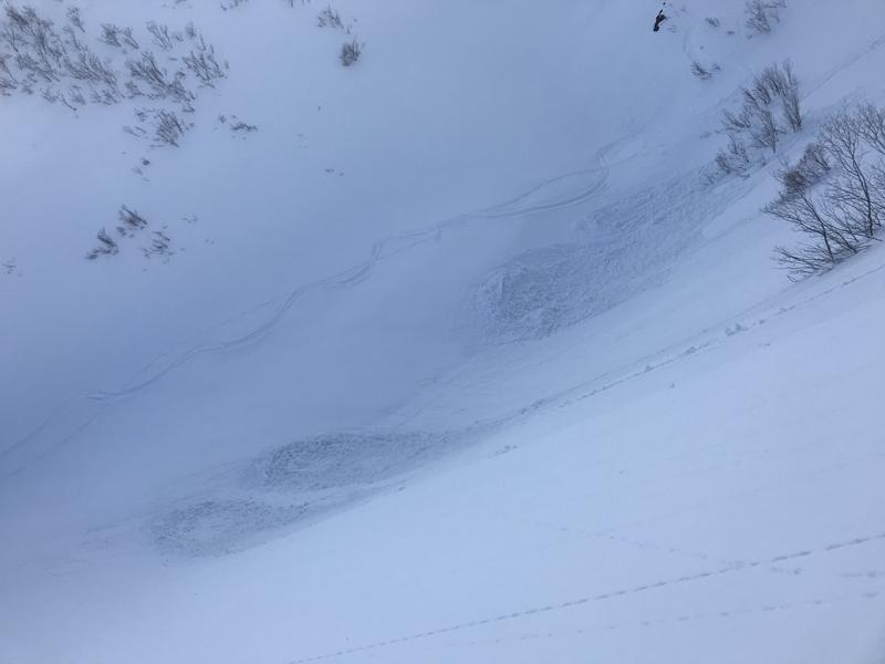
Heavy snowfall and drifting from intensifying westerly winds will cause a rapid rise in backcountry avalanche danger today. Dangerous avalanche conditions and CONSIDERABLE danger will quickly develop on upper and mid elevation slopes. People are likely to trigger avalanches of new and wind drifted snow, and natural avalanches will be increasingly possible as heavy snow is drifted into avalanche starting zones. The danger could rise to HIGH tonight, and fast and long-running natural avalanches may become likely.
- Evaluate snow and terrain carefully. Use caution while route-finding, and make conservative decisions.
- Avoid travel on and under steep drifted slopes, and stay clear of avalanche run-out zones.

Low
Moderate
Considerable
High
Extreme
Learn how to read the forecast here
Avalanche Warning
IN EFFECT FROM 1 PM MST THURSDAY TO 6 AM MST SATURDAY
FOR THE MOUNTAINS OF NORTHERN UTAH INCLUDING THE WASATCH RANGE...BEAR RIVER RANGE...UINTA MOUNTAINS
THE AVALANCHE DANGER WILL BECOME HIGH ON MANY SLOPES AT DIFFERENT ELEVATIONS AND ASPECTS.
HEAVY DENSE SNOW AND WINDS UP TO 100 MPH HAVE CREATED CREATED WIDESPREAD AREAS OF UNSTABLE SNOW. BOTH HUMAN TRIGGERED AND NATURAL AVALANCHES ARE LIKELY. STAY OFF OF AND OUT FROM UNDER SLOPES STEEPER THAN 30 DEGREES.
Weather and Snow
It's 22°F at the 8400' Tony Grove Snotel, and there is about 4 inches of new snow with 0.4" of Snow Water Equivalent. There is 79 inches of total snow, containing 119% of normal SWE. West-northwest winds increased overnight, and are currently blowing around 30 mph and gusting to 50 mph at the CSI Logan Peak weather station, and it's 18°F at 9700'.
Expect the avalanche danger to rise significantly today and tonight, with copious heavy snow and drifting from increasingly strong west winds overloading slopes with suspect snow structure, a few inches of cold light snow capping a slick and solid crust. As heavy new snow is drifted into avalanche stating zones, fast moving and long running natural avalanches will become increasingly possible.
It will snow heavily in the mountains today and tonight, with 1 to 2 feet of snow possible by tomorrow morning. Today, 8500' high temperatures are expected to be around 25°F, with 29 to 34 mph west-northwest winds, and gusts in the mid 40s. Wind chills will be around -16°F! Tonight, temperatures will be around 20°F, and we'll see very strong west winds, 35 to 40 mph with gusts around 50 mph. Snowfall and strong westerly winds will continue tomorrow, with 3 to 5 additional inches possible and 30 to 35 mph west winds. The avalanche danger will likely be HIGH, and we will avoid travel in backcountry avalanche terrain.
Recent Avalanches
We observed numerous natural dry loose avalanches in the Wellsville Mountain Wilderness Tuesday, and we easily and intentionally triggered a couple manageable sluffs on steep slopes as well. The cold powder was not sticking very well to the solid crust from last week's warm spell.

Avalanche Problem #1
Wind Drifted Snow
Type

Location

Likelihood

Size

Description
West-northwest winds picked up overnight, and there is plenty of nice light snow to move around. Dangerous avalanche conditions will develop and become more widespread today, and people are likely to trigger avalanches of wind drifted snow in exposed upper and mid elevation terrain. Natural avalanches will become possible during the day and could be likely tonight.
- Watch for and avoid fresh drifts near ridge lines and in and around terrain features like cliff bands, scoops, gully walls, and sub-ridges.
- Avoid ridge top cornices, which can break much further back than expected and start avalanches on slopes below.
Avalanche Problem #2
New Snow
Type

Location

Likelihood

Size

Description
Heavy and probably inverted new snow will pile up quickly on slopes with a few inches light loose and cold snow sitting on top of a widespread slick and solid melt-freeze crust from last week's warm spell. Human triggered and natural soft slab avalanches consisting of new snow will become increasingly likely as storm snow rapidly accumulates on steep slopes at all elevations today and tonight.
Additional Information
Dangerous roof avalanches are possible off structures in the Bear Lake Area and other in snowy mountain valley areas due to warming temperatures and rain at lower elevations.
General Announcements
Are you looking to improve your avalanche skills? We are offering a Backcountry 101: Introduction to Avalanches class at Powder Mountain February 14-15. Info and sign up HERE
The anual CROWBAR backcountry ski race will be on Saturday, February 8. The unique and classic backcountry race will be held at the Swan Flat/Garden City Trailhead in upper Logan Canyon. There are four divisions (Junior, Recreation, Heavy Metal & Race) with different climbs, descents, and technical booters. Participants must carry avalanche rescue gear (beacon, shovel, probe) and can use alpine touring gear, telemark skis, or splitboards. Register on UltraSignup, or sign up to volunteer at this year's race!
Thanks to the generous support of our Utah ski resorts and Ski Utah, we have discount lift tickets available. All proceeds from these go towards paying for avalanche forecasting and education! Get your tickets HERE.
EMAIL ADVISORY. If you would like to get the daily advisory by email you subscribe HERE.
Remember your information can save lives. If you see anything we should know about, please help us out by submitting snow and avalanche observations....HERE. You can also call us at 801-524-5304, email by clicking HERE, or include #utavy in your tweet or Instagram.
This forecast is from the USDA Forest Service, which is solely responsible for its content. The forecast describes general avalanche conditions and local variations always occur.
I will update this forecast before about 7:30 tomorrow morning.