Forecast for the Logan Area Mountains

Toby Weed
Issued by Toby Weed on
Tuesday morning, February 4, 2025
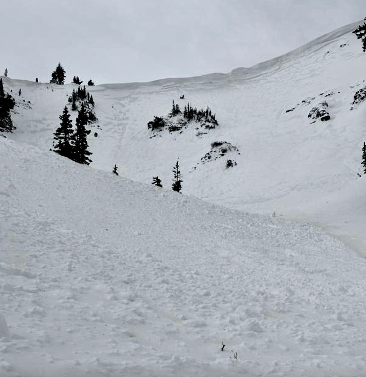
Dangerous avalanche conditions exist at all elevations in the backcountry. There is CONSIDERABLE danger on drifted slopes steeper than 30°, and people are likely to trigger dangerous slab avalanches failing on a sugary, persistent weak layer buried 1 to 3 feet deep. Rain saturated the snow in low and mid-elevation terrain, and mountain temperatures remain exceptionally warm, so wet avalanches are likely.
  • Careful snowpack evaluation, cautious route-finding, and conservative decision-making are essential for safe backcountry travel today.
  • Avoid steep slopes with recent deposits of wind-drifted snow and stay off and out from under those with warmth-softened, rain-saturated, moist or wet snow.
  • You'll find safer riding in the meadows and on slopes less than 30° not connected to or beneath steeper slopes.
Low
Moderate
Considerable
High
Extreme
Learn how to read the forecast here
Weather and Snow
Unseasonable warmth, even at upper elevations, turned the snow to mush and destroyed the nice powder. Very strong winds from the south-southwest continue to blow, but the winds can no longer drift much of the moist or saturated snow. Avalanche conditions are dangerous in the backcountry. Heavy new snow from the weekend storm and extensive drifting from strong winds from the southwest overloaded a widespread layer of pre-existing weak snow. Conditions are most hazardous on upper elevation slopes facing northwest through southeast, where natural wind slab avalanches remain possible, and people are likely to trigger dangerous wind slab avalanches. Rain and unseasonably warm temperatures saturated the snow in mid and low-elevation terrain, and with very warm mountain temperatures expected again today, wet avalanches are likely.
You'll find safer conditions and decent "surfy" moist and dense snow riding in the meadows and on low-angle slopes less than 30 degrees not connected to or under steeper terrain.
***Fishers need to be aware of potential wet avalanches coming down into the Logan River and stay out from under steep slopes with saturated snow.

-The Tony Grove Snotel at 8400 feet reports about 18 inches of settled heavy snow from the weekend storm with 2.9" SWE. It's too warm, 41° F, with 64 inches of total snow. (92% of normal for the date). At our Card Canyon weather station at 8800 feet, it's 40° F, and there is 44 inches of total snow.
-At the CSI Logan Peak weather station at 9700 feet, winds are blowing from the south-southwest 32 to 51 mph with overnight gusts of 71 mph, and it's 35° F. On Paris Peak, at 9500 feet, it is 33° F, and the winds are blowing from the south-southwest 15 to 30 mph, with overnight gusts near 50 mph.

NWS point forecast for the Naomi Peak Area: Today: Partly sunny, with a high near 44°. Breezy, with a southwest wind 20 to 22 mph, with gusts as high as 33 mph. Tonight: A 40% chance of snow, mainly after 11pm. Increasing clouds, with a low around 32° F. Breezy, with a southwest wind 20 to 26 mph, with gusts as high as 41 mph. New snow accumulation of less than a half inch possible. Wednesday: Snow. Temperature falling to around 25° F by 5pm. Wind chill values as low as 10° F. Windy, with a west wind 26 to 30 mph, with gusts as high as 45 mph. Chance of precipitation is 100%. New snow accumulation of 3 to 7 inches possible.
The next chance for snow comes Thursday evening and Friday and it is likely to be heavy at times on Friday, with a forecast for 13 to 21 inches of accumulation possible. Snow will continue into next weekend.

For more information, visit the UAC weather page here: Weather - Utah Avalanche Center
For Logan-specific weather, go here: Logan Mountain Weather - Utah Avalanche Center
Recent Avalanches
Numerous natural avalanches from overnight or early Sunday morning were observed at all elevations across the Logan Zone.
  • Large natural avalanches of wind-drifted snow were observed yesterday in the Cornice Ridge area south of Naomi Peak. These were 1 to 3 feet deep and 100 to 250 feet wide.
  • We observed widespread natural wind slab avalanches in the Wellsville Range on Sunday. These were on generally east-facing slopes <9000 feet, and looked to be 1 to 3 feet deep and 150 to 800+ feet wide, with some running close to 2000 vertical feet.
  • Natural wet loose and wet slab avalanches occurred late Saturday night or early Sunday morning in Logan Canyon, with a few slides running out onto Highway 89.
  • On Sunday, riders intentionally triggered a sizable wind slab on a test slope in the Crescent Lake area.
  • Numerous red flags of instability were reported, including long shooting cracks and extensive whumpfs.
  • Read about all avalanches and observations in the Logan Zone HERE.
  • *Remember, the information you share about avalanches you see or trigger in the backcountry could save lives.
Ad
Avalanche Problem #1
Wind Drifted Snow
Type
Location
Likelihood
Size
Description
Strong winds drifted snow into avalanche starting zones, overloading many slopes with dense, new snow. With continuing winds from the south-southwest expected today, we advise staying clear of steep, wind-drifted slopes. Wind slabs are most likely to be found on the lee side of major ridges and on corniced slopes, but they were also formed by cross-loading in and around terrain features like sub-ridges, gullies, and cliff bands. Hard wind slabs sometimes allow a person to get well out on them before suddenly releasing.
  • Avoid rounded pillows of snow that sound or feel hollow underfoot. Wind slabs are generally much stiffer than the surrounding snow.
  • Shooting cracks and collapsing or whumpfs are clear signs of instability.
  • Many wind slabs formed on weak faceted surface snow, now a buried persistent weak layer, and instability could last for a while.
  • Some wind slab avalanches could be triggered remotely (from a distance) or from below.
Avalanche Problem #2
Persistent Weak Layer
Type
Location
Likelihood
Size
Description
Before last weekend, the Logan area mountains developed a widespread layer of weak and sugary surface snow. Last weekend's storm overloaded the weak, sugary surface snow, and it is now a buried persistent weak layer. Drifting built slabs on the weak layer, but even in sheltered terrain, soft slabs of storm snow up to two feet deep will be possible to trigger.
Avalanche Problem #3
Wet Snow
Type
Location
Likelihood
Size
Description
With rain-saturated snow and exceptionally warm temperatures, expect to see wet loose and wet slab avalanches on snow-covered slopes facing all directions. These may gouge deeper into the snowpack as they run and become bigger than expected as they travel downhill. Suspect areas include all cut banks and slopes above the river and any slope steeper than 30° where the snow is saturated. Very warm mountain temperatures and sun could saturate the snow and cause wet avalanche potential in upper-elevation terrain as well. Low-elevation slopes facing southeast, south, and southwest are mostly bare or have only very shallow snow cover.
  • Rollerballs, pinwheels, and loose sluffs are signs of unstable snow.
  • Avoid being underneath steep slopes with rain-saturated, moist, or wet snow.
Additional Information

Yesterday, large natural avalanches were observed in the Cornice Ridge area.
Riders Sunday intentionally triggered this small avalanche on a small test slope in the Crescent Lake Area.
General Announcements
-National Forest Winter Recreation Travel Maps show where it's open to ride: UWCNF Logan, Ogden LRD Tony Grove, Franklin Basin CTNF Montpelier
-For all questions on forecasts, education, Know Before You Go, events, online purchases, or fundraising, call 801-365-5522.
-Remember the information you provide could save lives, especially if you see or trigger an avalanche. To report an avalanche or submit an observation from the backcountry, go HERE.
-Receive forecast region-specific text message alerts to receive messages about changing avalanche conditions, watches, and warnings. Sign up and update your preferences HERE.

This forecast is from the U.S.D.A. Forest Service, which is solely responsible for its content. This forecast describes general avalanche conditions, and local variations always occur.