Forecast for the Logan Area Mountains

Toby Weed
Issued by Toby Weed on
Thursday morning, February 27, 2025
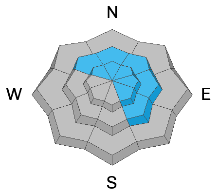
The avalanche danger is MODERATE, and human-triggered avalanches are possible in sunny terrain and on drifted upper and mid-elevation slopes steeper than 30°. Although becoming unlikely, people might trigger dangerous avalanches failing on a persistent weak layer buried 3 to 4 feet deep.
Evaluate the snow and terrain carefully, and continue to practice safe travel protocols.
Low
Moderate
Considerable
High
Extreme
Learn how to read the forecast here
Special Announcements
We are excited to announce the launch of our new mobile application, available on both Android and IOS. Get all the information you need to plan your backcountry adventure and keep the information at the tip of your fingers while you are out. Install the Android version HERE and the IOS version HERE.
Join the UAC on Thursday, March 6th at Brewvies in Salt Lake for friends, drinks, prizes, and an action-packed film! Alpine Assassins is a movie about incredible backcountry sledding and adventure. Doors open at 6:30 PM. Get your tickets HERE.
Weather and Snow
Sunny skies are expected today, and warming temperatures should soften up the refrozen snow. We found smooth supportable snow and fast springlike conditions at low elevations yesterday. Overnight temperatures were well below freezing, so the snow should stay hard for a while this morning, even in sunny terrain. You might find smooth corn snow this morning, but I expect the snow surface in most places will soften considerably by afternoon, and you might start sinking through the surface crust.
Strong winds out of the west earlier in the week added more issues to an already complex avalanche situation. We saw impressive plumes of drifting snow coming off the spine of the Wellsville Range Tuesday afternoon. The drifting built out existing cornices and formed stiff wind slabs in lee slope avalanche starting zones as well as wind-board crusts of varying thicknesses and sastrugi in windward terrain. Yesterday, we checked out a huge and very impressive natural avalanche in Hell Canyon, likely triggered by cornice fall during the wind event. (see photo below). This natural avalanche on an east-facing slope, Monday's Beirdneau Ridge avalanche on a south-facing slope, and Saturday's human-triggered Boss Canyon avalanche on an east-northeast-facing slope appear to have failed on different buried, persistent weak layers, highlighting the complexity of the avalanche problem.

-The Tony Grove Snotel at 8400 feet reports 26° F, with 93 inches of total snow. It's a toasty 35° F, at the Card Canyon weather station at 8800 feet, with 64 inches of total snow.
At 9700 feet at CSI's Logan Peak wx station, winds are blowing 16 to 18 mph from the north, and it's already 34° F. On Paris Peak at 9500 feet, it's 32° F, with winds blowing around 10 mph from the north.

Mountain temperatures are rising rapidly this morning. It's clear and we expect mostly sunny skies today, with mountain top high temperatures spiking around 39° F. Winds from the west will blow 5 to 7 mph. Tonight will be mostly clear with low temperatures around 27° F and winds from the northwest blowing 6 mph. Tomorrow will be sunny and even warmer, with 3 to 6 mph winds from the west-northwest and a high temperature around 43° F at 8500 feet.
A strong high-pressure system, with warm temperatures and plenty of sunshine, is expected to last through the weekend. Snow is expected early next week, beginning on Monday.

For more information, visit the UAC weather page here: Weather - Utah Avalanche Center
For Logan-specific weather, go here: Logan Mountain Weather - Utah Avalanche Center
Recent Avalanches
  • We checked out a large natural avalanche in Hell Canyon in the Wellsville Range that occurred with the strong westerly winds on Tuesday. We think it was triggered by cornice fall, and that it failed on a buried PWL. We estimate the avalanche on an east-facing slope at 8400 feet was about 4 feet deep x 700 feet wide, running 2200'vrt. Report is HERE.
  • Monday afternoon, I could see a large natural avalanche on the south face of Beirdneau Peak. Report is HERE. I'm not sure if this was a wet slab avalanche, but it was likely caused by solar warming and perhaps heat shock.
  • A snowmobiler triggered an avalanche near the warming hut in Boss Canyon on Saturday that unfortunately injured a rider who was below the slope. The large hard slab avalanche failed on a buried persistent weak layer and was 4 to 5 feet deep and about 500 feet wide. Read the preliminary report HERE.
Read about all avalanches and observations HERE.
Ad
Avalanche Problem #1
Persistent Weak Layer
Type
Location
Likelihood
Size
Description
While the likelihood of triggering an avalanche on a buried, persistent weak layer is decreasing, the consequences of doing so are not. Large and dangerous avalanches failing on one of a few buried persistent weak layers remain possible, especially in areas with shallower snow and poor snow structure. People could trigger avalanches of drifted snow that may then step down into deeper layers. The danger is most acute in upper-elevation terrain on rocky slopes with shallow snow cover facing northwest through southeast, but avalanches failing on a PWL are possible on slopes facing all directions.
Avalanche Problem #2
Wind Drifted Snow
Type
Location
Likelihood
Size
Description
Avalanches of wind-drifted snow and triggered cornice falls are still possible today. As we could see by the plumes of airborne snow drifting off the Wellsville Crest, winds picked up Tuesday, and they drifted heavy snow into lee slope avalanche starting zones, creating hard wind slabs. Avoid areas of stiff wind-drifted snow that may sound or feel hollow; wind-drifted snow is generally much denser than surrounding snow. Wind slabs will be found in and around terrain features like cliff bands, sub-ridges, and gullies. Watch for shooting cracks, and be aware that any avalanche may step down into deeper weak layers.
  • People should stay away from and out from under deceptive ridge-top cornices, which often break further back than expected and can trigger avalanches on drifted slopes below.
Avalanche Problem #3
Wet Snow
Type
Location
Likelihood
Size
Description
Cold temperatures overnight refroze the saturated snow, but we expect sunny skies, and already warm mountain temperatures will climb during the day today, elevating the danger of wet avalanches.
  • Roller balls, pinwheels, and natural sluffs are sure signs of instability.
  • If you start sinking into saturated snow, you should move off and stay out from under steep slopes.
Additional Information
A large natural avalanche occurred on Tuesdsay in Hell Canyon in the Wellsville Mountain Wilderness.

Here is the video we made about the 2/22 Boss Canyon Accident. Big thanks to all for sharing your photos and videos and for telling the terrifying story. We can all learn from this incident, and the lessons learned may well save lives.
General Announcements
-National Forest Winter Recreation Travel Maps show where it's open to ride: UWCNF Logan, Ogden LRD Tony Grove, Franklin Basin CTNF Montpelier
-For all questions on forecasts, education, Know Before You Go, events, online purchases, or fundraising, call 801-365-5522.
-Remember the information you provide could save lives, especially if you see or trigger an avalanche. To report an avalanche or submit an observation from the backcountry, go HERE.
-Receive forecast region-specific text message alerts to receive messages about changing avalanche conditions, watches, and warnings. Sign up and update your preferences HERE.

This forecast is from the U.S.D.A. Forest Service, which is solely responsible for its content. This forecast describes general avalanche conditions, and local variations always occur.