Forecast for the Logan Area Mountains

Toby Weed
Issued by Toby Weed for
Sunday, February 27, 2022
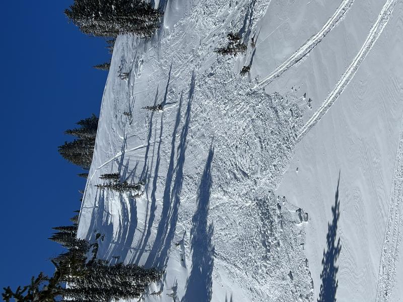
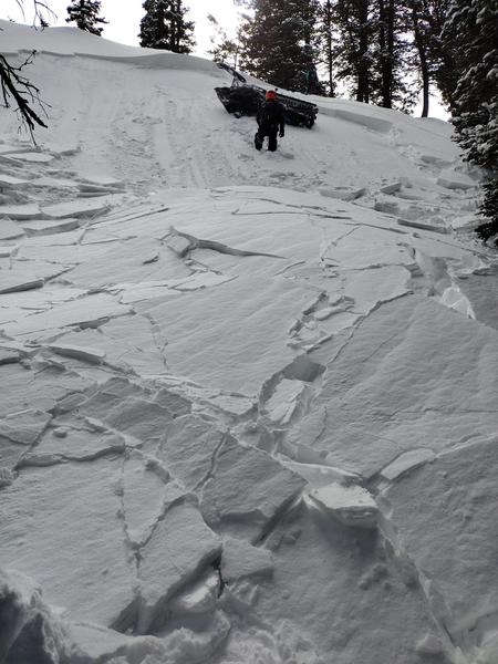
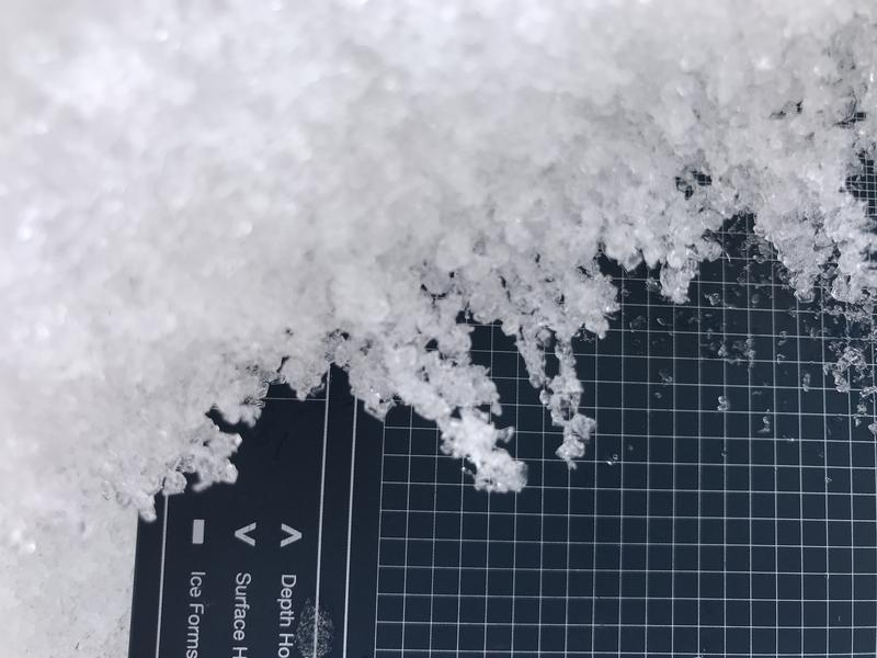
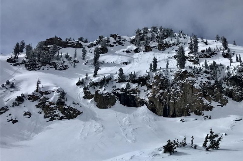
Heightened avalanche conditions exist on drifted slopes at mid and upper elevations in the backcountry. The danger is MODERATE, and people could trigger small slab avalanches of wind drifted snow on slopes steeper than 30°. Avalanches might be triggered remotely or from a distance. Loose dry sluffs are possible on steep slopes, and strong sun and warming temperatures will create potential for natural and triggered loose wet avalanches in steep sunny terrain. With very little new snow and good stability, the danger is LOW at lower elevations. Evaluate snow and terrain carefully.
  • Watch for and avoid recently wind drifted snow on steep slopes, especially in and around terrain features like gullies, scoops, sub-ridges, and cliff bands.
  • Avoid travel on or under steep sunny slopes with moist or saturated surface snow.
Low
Moderate
Considerable
High
Extreme
Learn how to read the forecast here
Special Announcements
Thanks to the generous support of our local resorts and Ski Utah, discount lift tickets are now available. Support the UAC while you ski at the resorts this season. Tickets are available HERE.
Weather and Snow
The 8400' Tony Grove Snotel reports 21°F this morning, and there is 66 inches of total snow at the site, with 83% of normal SWE for the date. Winds out of the west are blowing about 20 mph at the 9700' CSI Logan Peak weather station. A bit of new snow this week improved backcountry riding conditions, and you'll find classic dust-on-crust conditions in most areas, with pockets of nice shallow powder in sheltered terrain. Drifting of the new snow created heightened avalanche conditions at mid and upper elevations, and in the past few days, people triggered several small wind slab avalanches at mid and upper elevations in the Bear River Range.

At upper elevations, this week's squirrly winds really whipped up the few inches of fresh powder and created heightened avalanche conditions.
  • Expect increasing clouds and warming temperatures in the mountains today. 8500' high temperatures will be around 27°F, and moderate southwest winds will create wind chill values as low as -10°F this morning.
  • It will be mostly cloudy and then clearing tonight, temperatures will drop to around 11°F, with light south-southwest winds.
  • Expect sunny skies tomorrow, with high temperatures around 32°F, and 5 to 10 mph southwest winds.
  • Looks like mostly sunny, fair weather, and warming temperatures are in store for the next few days, with the next chance for accumulating snow coming at the end of the week.

Recent Avalanches
  • We got a report of a handful of small intentionally triggered wind slabs by riders dropping cornice or (ski) cutting slopes in very steep upper elevation terrain in the Tony Grove Area yesterday.
  • Riders report a shallow wind slab avalanche unintentionally triggered by rider in the Cornice Ridge Area yesterday morning. The 6-10" deep x 60' wide avalanche of stiff drifted snow at about 9000' occurred on a steep northeast facing slope.

Two unintentionally triggered avalanches were reported from Wednesday on north facing slopes above 8000'.
1)-A party of skiers remotely triggered a 10" deep and 150' wide pocket of drifted snow from the ridge above in the Mt. Naomi Wilderness.
2)-A rider was caught and carried a short distance and his sled overturned in a soft wind slab avalanche, 15" to 18" deep and 60' wide a couple miles north of the ID state line in Franklin Basin.
A rider was caught and carried a short distance and his sled overturned in this small avalanche of wind drifted snow on Wednesday.
Check out all the recent backcountry observations and avalanche reports from across Utah HERE
Ad
Avalanche Problem #1
Wind Drifted Snow
Type
Location
Likelihood
Size
Description
Winds will be light today, and a few inches of fresh snow will hide drifts from earlier in the week. People could trigger slab avalanches of previously wind drifted snow in steep upper and mid elevation terrain. This week's squirrly winds easily picked up fresh powder on the surface and deposited it in deceleration zones on sugary faceted snow. The drifting from winds from different dirrections created stiff wind slabs in perhaps unexpected places. Some wind slabs will remain unstable for a while because the sugary snow that they formed on is a buried persistent weak layer.
  • Avoid recently or previously drifted snow on steep slopes at mid and upper elevations on the lee side of ridges and in and around terrain features like sub-ridges, gullies, and cliff bands.
  • Avalanches of wind drifted snow failing on a persistent weak layer could be triggered remotely, from a distance, or below.
Chains of facets under a weakening sun-crust in the upper part of the snowpack. 2-25-2022
Avalanche Problem #2
Wet Snow
Type
Location
Likelihood
Size
Description
Loose dry avalanches (or sluffs) of powder and/or recrystallized or faceted surface snow remain possible in terrain sheltered from the east winds, on very steep and sustained slopes. With much warmer temperatures expected today and strong late February sun, this week's fresh snow will rapidly become moist and prone to loose avalanching in steep terrain, and natural loose wet avalanches entraining damp surface snow (also sluffs) will become possible.
  • Manage loose avalanches by staying out of constricting terrain, like drainage gullies, and moving out of the fall line so you don't get caught by your own sluff.
  • Avoid being caught and pulled into terrain traps below you like trees, gullies, or benches.
  • Roller balls, pinwheels, and natural sluffs of wet surface snow indicate potential for more wet activity.
  • Natural loose wet avalanches could start in rock bands or cliffy areas and fan out, entraining moist surface snow on steep slopes below.
Loose avalanches or sluffs of new snow on the south shoulder of Naomi Peak. (2-22-2022)
Additional Information
  • Now is a great time to practice your avalanche rescue skills. Thanks to the generous support of Northstar, the Franklin Basin Beacon Training Park is up and running. The park is located directly west of the parking lot and is open for anyone to use. All you need is your beacon and probe. Please do not dig up the transmitters.
  • Always follow safe backcountry travel protocols. Go one person at a time in avalanche terrain, while the rest of your party watches from a safe area. (practice anytime while traveling on or under backcountry slopes steeper than 30°)
  • Check your avalanche rescue equipment, change your batteries, and practice often with your backcountry partners.
    Check slope angles, and to avoid avalanche terrain stay off of and out from under slopes steeper than 30° and adjacent slopes. Video Here
General Announcements
Special thank you to Polaris and Northstar...Video Here
Who's up for some free avalanche training? Get a refresher, become better prepared for an upcoming avalanche class, or just boost your skills. Go to https://learn.kbyg.org/ and scroll down to Step 2 for a series of interactive online avalanche courses produced by the UAC.
  • Check out all the upcoming education classes and clinics HERE.
  • Please submit your observations from the backcountry HERE.
This information does not apply to developed ski areas or highways where avalanche control is normally done. This forecast is from the U.S.D.A. Forest Service, which is solely responsible for its content. This forecast describes general avalanche conditions and local variations always occur.