Donate to the 2024 Spring Campaign to help rebuild the UAC website.

Forecast for the Logan Area Mountains

Toby Weed
Issued by Toby Weed for
Monday, February 25, 2019
CONSIDERABLE: Accumulating snow and continuing strong southwest winds will cause increasing avalanche danger in the backcountry today. Dangerous conditions exist, and triggered avalanches one to three feet deep, consisting of wind drifted snow, are likely at upper elevations. Drifting snow will cause the danger to continue to rise and become more widespread today, with natural avalanche activity possible in some areas this afternoon.
  • Evaluate snow and terrain carefully, and use extra caution in drifted upper elevation terrain.
  • Avoid and stay out from under large and growing ridge top cornices and steep slopes with recent deposits of wind drifted snow.
Low
Moderate
Considerable
High
Extreme
Learn how to read the forecast here
Weather and Snow
Continuing strong southwest winds and snowfall will cause rising avalanche danger today. Dangerous conditions exist this morning on some upper elevation slopes where human triggered wind slab avalanches 1 to 3 feet deep are likely. You can still find stellar powder conditions in sheltered terrain, and cold temperatures have kept it nice even on sunny slopes.

The Tony Grove Snotel at 8400' reports 4 inches of new snow early this morning. It's 24º F and there's 89" of total snow containing 102% of average SWE for the date. It's 19º F, at the 9700' CSI Logan Peak weather station, and southwest winds are currently averaging around 35 mph, with a 55 mph gust early this morning.
The National Weather Service in Pocatello has continued a Winter Storm Warning for the Bear River Range in SE Idaho due to snow and drifting. Several weak disturbances will impact northern Utah through Thursday morning. A stronger storm will impact much of the state Thursday into Friday.
Snow showers will continue today, with 2 to 4 inches possible. High temperatures at 8500' are expected to be around 30º F, with 25 to 35 mph southwest winds, gusting to around 50 mph. It will snow tonight, with 2 to 4 inches possible, low temperatures expected to be around 19º F, with continuing 30 to 35 mph southwest winds gusting to around 50 mph. Snow is likely tomorrow, with 3 to 7 inches possible, and the sustained southwest winds will continue to build huge cornices and drift snow into upper elevation north and east facing avalanche starting zones at 30 to 35 mph with gusts around 50 mph.
Recent Avalanches
A couple parties report triggering 1 to 3 foot deep avalanches and observing naturals involving wind drifted snow in the Ogden Area Backcountry yesterday.
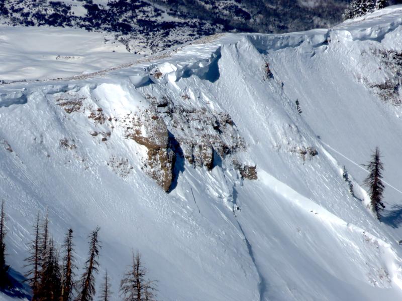
A large natural hard slab avalanche was triggered by cornice fall in upper Chalk Creek in the Western Uinta Range. The avalanche occurred after southwest winds intensified Saturday Night.
Ad
Avalanche Problem #1
Wind Drifted Snow
Type
Location
Likelihood
Size
Description
Heightened avalanche conditions exist on many drifted slopes, and dangerous conditions are developing at upper elevations and on some mid elevation slopes facing northwest, north, northeast, and east. Avalanches involving wind drifted snow could be small, soft, easily triggered, and manageable. or harder, larger, and much more dangerous. Hard wind slabs sometimes let people get out on them before releasing.
  • You should stay clear of ridge top cornices, which have grown quite large in places. Cornices are likely to break much further back than expected and may trigger large avalanches on steep slopes below.
  • Avoid wind drifted snow on the lee side of major ridges and in and around terrain features like sub-ridges, scoops, stringers, cliff bands, and gullies.
Avalanche Problem #2
Persistent Weak Layer
Type
Location
Likelihood
Size
Description
It's unlikely for a person to trigger one, but dangerous avalanches failing on a buried persistent weak layer remain possible on isolated slopes with poor snow structure. We've found areas with shallow, weak snow at mid elevations, on often scoured upper elevation slopes, on slopes that avalanched earlier in the season, and in treed or rocky areas. Dangerous 2 to 4 feet deep hard slab avalanches are possible to trigger from a shallow area on the slab, and some might be triggered remotely, from a distance, or below. Be especially careful in areas with shallow snow cover or anywhere where you sink to the ground in weak snow when you get off your sled or skis. Hard deep slab avalanches might be triggered from a shallower part of the slab.
  • Continue to avoid recent or older wind drifted snow on very steep, rocky, or shallow slopes with poor snow structure.
Additional Information
I will update this forecast Wednesday morning.
The new weather station at the WSU Bloomington Canyon Yurt is up and running. Data available HERE
Now is a great time to practice companion rescue techniques with your backcountry partners. You should check out and use the new Avalanche Beacon Training Park we set up at the Franklin Basin trailhead. Special thanks to Northstars Ultimate Outdoors, USU Outdoor Program, and Beaver Mountain Ski Patrol for helping us to make this possible.
General Announcements
The Beaver Mountain Backside is the backcountry, and it is avalanche terrain. Same goes for the steep rocky terrain adjacent to Cherry Peak Resort. If you leave a ski area boundary, you and your partners should carry and practice with avalanche rescue equipment and follow safe backcountry travel protocols.
Check out the improved weather links, road conditions, and weather links for each forecast region on the new UAC IOS App. Do you use the NOAA point forecast? If so, now you can bookmark your favorite weather locations in "My Weather" in the App. HERE
Are you new to the backcountry or looking to refresh your skills? The UAC has released a free 5-part avalanche skills eLearning series. HERE
If you would like to get the daily advisory by email you subscribe HERE.
Support the UAC through your daily shopping. When you shop at Smith's, or online at REI, Backcountry.com, Patagonia, NRS, Amazon, eBay by clicking on these links, they donate a portion of your purchase to the UAC. If you sell on eBay, you can have your See our Affiliate Page for more details on how you can support the UAC when you shop
Remember your information can save lives. If you see anything we should know about, please help us out by submitting snow and avalanche observations. HERE You can call us at 801-524-5304, email by clicking HERE, or include #utavy in your Instagram.
This forecast is from the U.S.D.A. Forest Service, which is solely responsible for its content. The forecast describes general avalanche conditions and local variations always occur.