Issued by Toby Weed on Saturday morning, February 20, 2021
DANGEROUS AVALANCHE CONDITIONS EXIST.
There is CONSIDERABLE avalanche danger on many steep slopes in the backcountry today. People are likely to trigger dangerous avalanches and natural avalanches are possible, especially on drifted upper elevation slopes. Avalanches could be large, destructive, and deadly.
Use extreme caution in the backcountry. Expect unstable snow conditions.
Choose safe routes in low angled terrain well out from under and not connected to drifted slopes steeper than about 30 degrees.
The Utah Avalanche Center recommends people avoid travel on or underneath slopes steeper than about 30 degrees in the backcountry.
Avalanches triggered by people could be extremely large, very dangerous, unexpected, and deadly.
Even if you are experienced and have the proper avalanche safety equipment, you should still avoid all steep slopes in the backcountry.
Special Announcements
The UAC in Logan is offering a Youth BC 101 avalanche class for youth aged 16-20 on Feb 21. For more info and to register, click HERE
Weather and Snow
Decent snowfall is visible on the Beaver Mountain Webcams this morning. Temperatures are also falling, there is a couple inches of new snow with 0.5" SWE in the last 24 hours, and it's 23°F at the 8400' Tony Grove Snotel. There is 82 inches of total snow and now 86% of normal SWE. West winds are still drifting snow this morning after blowing snow around at upper elevations yesterday, but the wind sensor on Logan Peak is down, (perhaps iced over).
Very large natural avalanches were widespread across the Logan Zone on Tuesday, Tuesday night, and Wednesday. In several areas, natural avalanches were incredibly extensive, with nearly all avalanche paths producing big slides.
We went back up to Wood Camp Thursday to check out a huge natural avalanche that was reported on Wednesday morning.
Snow is expected in the mountains today, with 2 to 4 inches of additional accumulation possible on upper elevation slopes. High temperatures at 8500' will be around 17°F, with 15 to 20 mph northwest winds. Snow showers could continue at times this afternoon and tonight, with continuing northwest winds and 1 to 3 inches possible. Tomorrow will be mostly cloudy, with high temperatures around 20°F and west winds creating wind chill values as low as -9°F.
The weather pattern appears unsettled heading into next week.
Recent Avalanches
Clearing revealed that a significant natural cycle occurred across the Logan Zone, with many huge avalanches having occurred late in the big storm, (Tuesday night---->early Wednesday morning). Very large natural avalanches failing on a buried sugary persistent weak layer and running well out into lower elevation runout zones were widespread and occurred on slopes facing every direction. Reports of extensive and giant natural avalanches include most avalanche paths in the Wellsville Mountain and Mount Naomi Wildernesses, in Upper Spring Hollow, and Wood Camp Hollow. Big avalanches were also reported near Tony Grove Lake, Providence Canyon, Dry Canyon, Cub River, Franklin Basin, and in the Bloomington Lake Area above Bear Lake.
A large natural avalanche was observed Thursday off the north shoulder of Logan Peak in Upper Spring Hollow. (thanks Wally)
Avalanche Problem #1
Persistent Weak Layer
Type
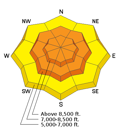
Location
Likelihood
Size
Description
Heavy snowfall and westerly winds added significant weight to slopes that were already near the tipping point. Buried persistent weak layers consisting of sugary faceted snow are widespread across the Logan Zone, and the threat of large and deadly avalanches failing on weak snow near the ground is quite real. Avalanches are likely on steep slopes that did not naturally avalanche recently, where a slab of more cohesive wind drifted snow formed on top of the weak snow.
Avalanches failing on a buried persistent weak layer might be triggered remotely, from a distance, or worse from below!
Cracking and collapsing of the snow are a red flag, indicating unstable snow conditions.
Avalanche Problem #2
Wind Drifted Snow
Type
Location
Likelihood
Size
Description
Avalanches of wind drifted snow are likely where drifts formed recently and are building today on slopes with buried persistent weak layers.
Wind slabs are often rounded and chalky looking, and they can sound and feel hollow and drum-like when you walk on them.
Watch for and avoid stiffer drifted snow near ridge tops and in and around terrain features like gullies, scoops, cliff bands, and sub ridges.
Stay well back from cornice edges as they can break much further back than you expect and avalanches are likely on slopes below.
Additional Information
Do you have the essential avalanche rescue gear (transceiver, probe, and shovel) and do you know how to use them? Watch this video to see how the three pieces of equipment work together. HERE
Please keep practicing with the Beacon Training Park at the Franklin Basin Trailhead. Test yourself and your riding partners. It is free, fun, and easy to use.
General Announcements
Thanks to the generous support of our local resorts, Ski Utah, and Backcountry, discount lift tickets are now available. Support the UAC while you ski at the resorts this season. Tickets are available here.
EMAIL ADVISORY. If you would like to get the daily advisory by email you subscribe HERE.
Remember your information can save lives. If you see anything we should know about, please help us out by submitting snow and avalanche observations....HERE. You can also call us at 801-524-5304, email by clickingHERE, or include #utavy in your tweet or Instagram.
I will update this forecast by around 7:30 tomorrow morning.
This forecast is from the USDA Forest Service, which is solely responsible for its content. The forecast describes general avalanche conditions and local variations always occur.