Forecast for the Logan Area Mountains

Toby Weed
Issued by Toby Weed on
Wednesday morning, February 11, 2026

A winter storm today will overload slopes with weak snow, elevating the avalanche danger to MODERATE. Heightened avalanche conditions will develop on drifted slopes, where people could trigger soft slab avalanches of drifted storm snow.

Low
Moderate
Considerable
High
Extreme
Learn how to read the forecast here
Weather and Snow

Bring an extra pair of goggles if you head out into the backcountry today. It's already starting to snow in the mountains this morning, with light snowfall visible on Beaver Mountain's webcams and radar (Local Radar Super Resolution Base Reflectivity) showing precipitation filling in from the southwest. Periods of heavy snowfall and drifting by winds blowing from the southwest will improve the riding and elevate risk in the backcountry, with heightened avalanche conditions developing in drifted terrain at upper elevations and on mid-elevation slopes facing northwest through east that are steeper than 30 degrees. Terrain below about 7000 feet has very shallow snow cover, with sunny slopes facing southeast through west completely bare of snow before today's storm.

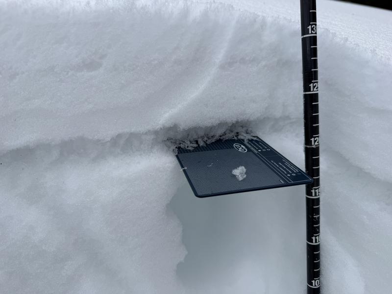
Monday, about 3 inches of new snow accumulated in upper-elevation terrain (above about 8500 feet). The dusting of new snow really improved the riding conditions and certainly freshened the view. After a dry few weeks, the snow on the ground is quite variable, with plenty of old tracks, wind, and sun crusts of differing thickness. sastrugi and hard wind drifts in exposed terrain, shallowly buried, cornflake-like surface hoar, and soft and fairly deep, recrystallized powder (or faceted surface snow) in sheltered northerly terrain.

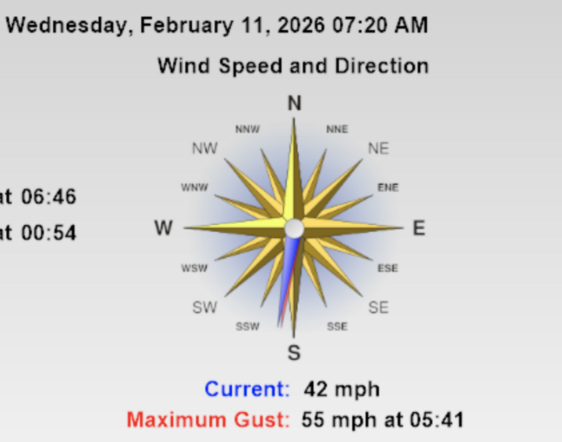
The wind intensified significantly overnight, and it is howling this morning on the summit of Logan Peak (9700 feet). It's currently blowing 30 to 37 mph, with gusts to 55 mph from the south. At 8700 feet, the UAC Card Canyon weather station reads a temperature of 30°F, and there's 41 inches of total snow. The Tony Grove Snotel at 8400 feet reports an inch of new snow from overnight. It's 33°F, and there's 53 inches of total snow. It's 24°F on Paris Peak at 9500 feet, and the wind is now blowing 17 to 30 mph from the south-southwest.

The National Weather Service has continued a Winter Weather Advisory for the Logan Zone, through Thursday morning. We're keeping our fingers crossed; 3 to 7 inches of new snow could accumulate in upper elevation terrain in the Bear River Range today. Expect high temperatures at 8500' around 35°F and moderate southwest winds. Snowfall will continue into tonight, with another 1 to 3 inches of accumulation possible. The new snow will begin to overload weak layers that were buried and preserved by Monday's dusting of fresh snow, elevating avalanche conditions in the backcountry. Monday, we found an obvious, shallowly buried weak layer comprised of huge surface hoar crystals in upper-elevation terrain near Emigration Summit in the Northern Bear River Range. See the observation HERE

Recent Avalanches

There was some natural wet activity last week, but no avalanches were reported locally since then. For all observations and avalanche activity in the Logan zone, go HERE

Avalanche Problem #1
Wind Drifted Snow
Type
Location
Likelihood
Size
Description

Today's wind from the southwest will drift the fresh snow, picking it up in lower-angled fetch areas on the windward side of ridges and redepositing it as wind slabs on steep lee slopes and around terrain features near the ridge tops. Wind will also influence how the new snow accumulates over terrain, with storm snow preferentially deposited over wide areas on lee slopes.

  • Today, people could trigger soft wind slabs up to around a foot deep, and some of these could be quite sensitive.
  • Soft slabs of wind-drifted storm snow will form in and around terrain features like sub-ridges, rock outcroppings, gullies, and mid-slope rollovers.
  • Cracking in drifted snow is an obvious sign of instability.
  • Some soft wind slab avalanches could be triggered remotely.

Additional Information
  • Travel with a partner, and cross or ride slopes steeper than 30 degrees one at a time while the rest of your group watches from a safe spot.
  • Ensure that everyone in the group has avalanche rescue equipment (a transceiver, probe, and shovel) and knows how to use it.

-----------------------------------------------------------------------------------------------------------------------------------------------------------------

-For all questions on forecasts, education, Know Before You Go, events, online purchases, or fundraising, call 801-365-5522.

Did you know the UAC hosts a podcast? Episode 2 of Season IX is just out - AI, Machine Learning, and the Value of Expert Intuition at the Utah Avalanche Center.

Are you interested in learning more about avalanches? Visit our education page for details on all our classes.

For more information, visit the UAC weather page here: UAC Weather Page For Logan-specific weather, go here: Logan Mountain Weather

-Remember, the information you provide could save lives, especially if you see or trigger an avalanche. To report an avalanche or submit an observation from the backcountry, go HERE

-Receive forecast region-specific text message alerts to receive messages about changing avalanche conditions, watches, and warnings. Sign up and update your preferences HERE

This forecast is from the U.S.D.A. Forest Service, which is solely responsible for its content. This forecast describes general avalanche conditions and local variations always occur.

General Announcements
This information does not apply to developed ski areas or highways where avalanche control is normally done. This forecast is from the U.S.D.A. Forest Service, which is solely responsible for its content. This forecast describes general avalanche conditions and local variations always occur.