UDOT PLANNED AVALANCHE CLOSURES!!

Forecast for the Logan Area Mountains

Toby Weed
Issued by Toby Weed for
Wednesday, December 7, 2022
Widespread buried persistent weak layers are creating elevated avalanche conditions and MODERATE danger on many backcountry slopes across the Logan Zone. Also areas with more dangerous conditions and CONSIDERABLE danger exist on drifted upper elevation slopes, where people could trigger hard slab avalanches of previously drifted snow failing on a persistent weak layer 1-3' deep and perhaps a couple hundred feet wide.

Evaluate snow and terrain carefully. You'll find nice powder and much safer conditions in lower-angle terrain, sheltered slopes, and at lower elevations.
Low
Moderate
Considerable
High
Extreme
Learn how to read the forecast here
Special Announcements
Thanks for showing up last night and supporting the UAC. It was great to see everybody at the Cache! You made our annual Pray for Snow party/fundraiser a big success.

Join the Utah Avalanche Center and the Division of Outdoor Recreation to celebrate the Fourth Annual Avalanche Awareness week, from December 4 - December 11. Click HERE to view the full list of events for the week. A few highlighted events for the Logan area:
  • Join us Wednesday, December 7th at USU for a Know Before You Go. Find more info HERE.
  • Join us Saturday, December 10th at Beaver Mountain for FREE UAC and USU Beacon Clinic. Find more info HERE.
Weather and Snow
Areas with dangerous avalanche conditions exist at upper elevations in the backcountry. Last week's heavy snow and drifting overloaded many slopes plagued by buried weak layers and poor snow structure. Dangerous human-triggered avalanches are possible for people to trigger, especially on previously drifted upper and mid-elevation slopes. No new avalanches were reported since the weekend, but observers continue to report audible collapses or "wumpfs" from across the zone. Collapsing indicates unstable snow and real potential for dangerous slab avalanches failing on a buried persistent weak layer. Yesterday in Providence Canyon we triggered a couple wumpfs, but we also noted mixed test results and apparently improving overall stability.

Today will be mostly sunny in the mountains with high temperatures at 8500' around 23°F and 6 to 10 mph southeast winds. Tomorrow will start off cloudy but be clearing and cold. Cold, unsettled weather will continue through the work week, and it looks like a little snow is possible on Friday. Another decent round of storminess is coming together for the weekend, with a potentially prolonged period of snow Saturday night through Monday.
Recent Avalanches
No new avalanches were reported in the backcountry since a pretty active weekend when several remotely triggered and some large natural avalanches were reported.
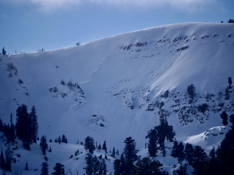
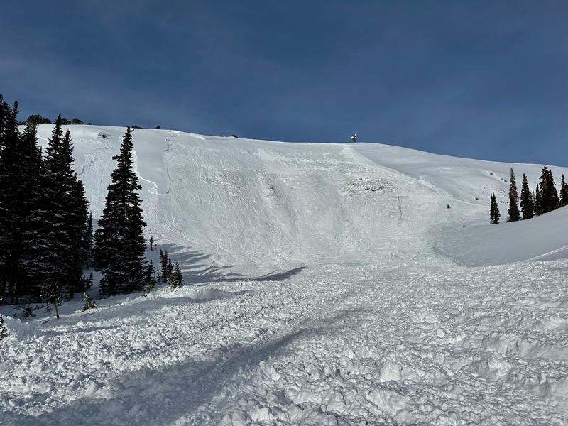
On Saturday we could see this sizable recent natural avalanche under where the Grandfather Cornice forms on Cornice Ridge....
***See our updated list of observed avalanches from across Utah HERE
Ad
Avalanche Problem #1
Persistent Weak Layer
Type
Location
Likelihood
Size
Description
The situation is very simple - there is a persistent weak layer (PWL) of faceted snow from roughly 16 days of clear and cold weather in November that now has 1-3' feet of snow on top of it. Over the weekend, this layer produced both small and large avalanches, and the snow is slow to stabilize on many slopes.
  • We've found buried layers of sugary snow at all elevations and on slopes facing every direction. The persistent weak layer (PWL) problem has the potential to get worse as widespread slopes with poor snow structure are overloaded, and the problem is likely to be an issue for a while.
  • Areas plagued by a very sensitive PWL consisting of buried feathers of surface hoar are also widespread, but we've found them mostly in sheltered low and mid-elevation terrain. Persistent weak layers consisting of surface hoar are notoriously tricky, often surprising and sometimes catching experienced avy pros off guard. Avalanches failing on buried surface hoar may occur on lower angled slopes than you might expect.
  • Red Flags indicating PWL instability will include audible collapses or wumpfs and shooting cracks. Slab avalanches failing on a buried persistent weak layer are likely to be remotely triggered from a distance, hopefully from above or from an adjacent slope, and not from below.
Last week's new snow fell on bare ground or very shallow snow on low and many mid elevation sunny slopes facing W, SW, S, SE, so the danger of avalanches is lower in these areas.
Avalanche Problem #2
Wind Drifted Snow
Type
Location
Likelihood
Size
Description
There is not much drifting going on currently with moderate winds in the mountains and only a few inches of fresh snow to blow around, but significant drifting and scouring occurred late last week with sustained and strong south winds. Dangerous large avalanches occurred in steep upper elevation terrain where strong winds found plenty of powder to move around and created thick hard slabs on slopes with buried persistent weak layers. Some avalanches of wind drifted snow at upper elevations over the weekend were a couple feet deep and a few hundred feet wide, and some created piles of debris the size of a few football fields.
  • Drifted snow is stiffer and more compacted than non-drifted snow. Recent strong winds created harder drifts (called hard slabs if they avalanche). Hard slabs are often stubborn, notorious for allowing people to get out on them before releasing, kind of like a giant mouse trap!
  • Slab avalanches of wind drifted snow failing on a persistent weak layer might be triggered remotely, from a distance, or even below!
Additional Information
Take the all-new online avalanche courses the UAC built for Know Before You Go or take other online courses listed on the KBYG website (Develop skills -> Online Learning).

Get your avalanche rescue gear ready for winter.
  • Put fresh batteries in your transceiver and update the firmware.
  • Inspect your shovel and probe.
  • Get your airbag backpack ready by possibly doing a test deployment and update the firmware if it is an electric version.
  • Practice Companion Rescue with your backcountry partners.
General Announcements
Please submit your observations from the backcountry HERE.
For a list of avalanche classes from the Utah Avalanche Center go HERE
For information on where you can ride your sled or snowbike, check out this map of the winter travel plan for the Tony Grove and Franklin Basin Areas HERE.
The Tony Grove Road and other forest roads in the Logan Ranger District are not maintained for wheeled vehicles in the winter.
This information does not apply to developed ski areas or highways where avalanche control is normally done. This forecast is from the U.S.D.A. Forest Service, which is solely responsible for its content. This forecast describes general avalanche conditions and local variations always occur.