Donate Now to Our Year End Campaign!

Forecast for the Logan Area Mountains

Toby Weed
Issued by Toby Weed on
Wednesday morning, December 24, 2025

MODERATE: Heightened avalanche conditions exist on upper elevation slopes steeper than 30 degrees. People could trigger dangerous slab avalanches failing up to 2 feet deep on a sugary, persistent weak layer buried near the ground. Wet avalanches may be possible in very steep terrain.

  • Evaluate snow and terrain carefully.
  • Slopes below about 7000 feet in elevation across the zone are bare of snow or have only minimal snow cover.
Low
Moderate
Considerable
High
Extreme
Learn how to read the forecast here
Weather and Snow

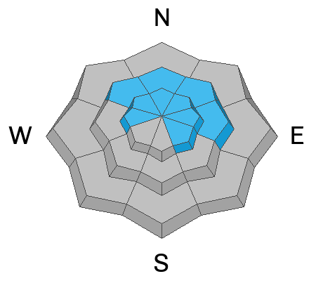
Dangerous, hard slab avalanches up to 2 feet deep remain possible on steep slopes in isolated upper elevation terrain. Previously drifted slopes with poor snow structure (a slab of dense snow on top of weak faceted snow near the ground) are most suspect. Yesterday, I found good snow coverage and access, with crusty, damp snow in the Emigration Canyon Area. There is enough snow to cover the rocks, and people are riding from the Copenhagen Basin TH. Access to upper elevation terrain in most of the zone is a challenge over dry or icy roads and trails at lower elevations (below about 7000')

Temperatures appear to be dropping a little this morning. It's 38°F at the Tony Grove Snotel this morning with 30" of total snow. The UAC Card Canyon site is showing 37°F with 17" of total snow. On Logan Peak, winds are blowing from the south 25 to 30 mph and gusting to 56 mph early this morning. On Paris Peak, it's 31°F, and the wind is from the south at around 10 mph.

Expect increasing clouds and rain, and snow in the mountains today, with little accumulation expected. High temperatures at 8500 feet will be around 44°F, and winds will blow from the south-southwest 15 to 20 mph, with gusts near 40 mph. Rain and snow are expected tonight, and some thunder is also possible, but accumulations will be minimal. Steady temperature around 38°F. Breezy, with a wind from the south-southwest 25 to 30 mph, with gusts as high as 50 mph. Snow showers are expected on Christmas Day, with about an inch of accumulation, and some thunder is possible. High temperatures will be near 37°F. Breezy, with a southwest wind around 25 mph, with gusts as high as 50 mph.

***We're very happy to report that mountain temperatures will finally drop on Christmas Night, and snowfall is likely through Friday night (snowfall could be heavy at times), with 1 to 2 feet of accumulation from the storm possible at upper elevations in the Bear River Range.

Recent Avalanches

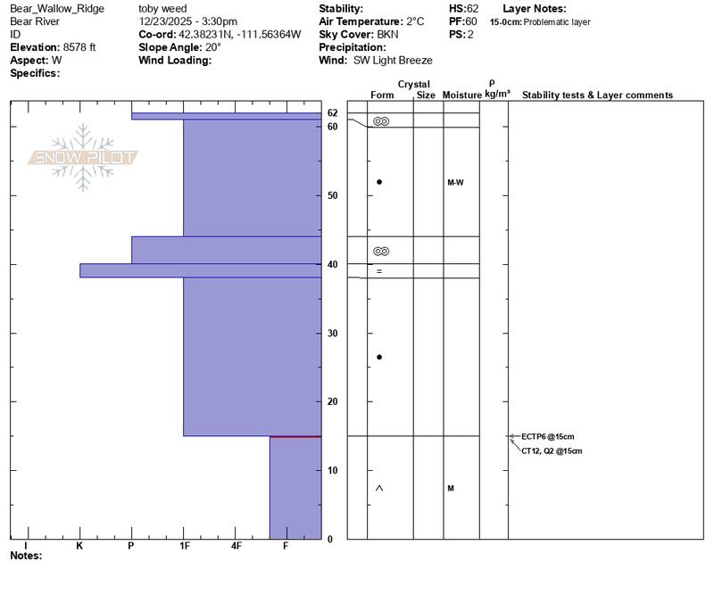
No new avalanches have been reported locally since early December. For all observations and avalanche activity in the Logan Zone, go HERE

Avalanche Problem #1
Persistent Weak Layer
Type
Location
Likelihood
Size
Description

At upper elevations, weak, faceted snow from November is buried beneath a thick crust or multiple crusts and dense snow. On steep, previously wind-drifted slopes, people could trigger avalanches that propagate widely.

  • Collapsing, indicated by shooting cracks and/or whumpfs, is a warning sign of unstable snow.
  • Avalanches might be triggered remotely (from a distance or below).
  • Even small avalanches can have serious consequences in shallow snow conditions, where a slide could drag you through rocks or downed trees below.
  • Stick to safe travel practices: travel with a partner, and cross or ride steep slopes one at a time while the rest of your group watches from a safe spot.

See Bear Wallow ECTP_6 video below

Avalanche Problem #2
Wet Snow
Type
Location
Likelihood
Size
Description

Loose wet avalanches of rain-saturated snow are possible on steep slopes with sufficient snow cover. Roller balls, pinwheels, and wet sluffs indicate potential for wet avalanche activity.

Additional Information

Are you interested in learning more about avalanches? Visit our education page for details on all our classes.

For more information, visit the UAC weather page here: UAC Weather Page For Logan-specific weather, go here: Logan Mountain Weather

-For all questions on forecasts, education, Know Before You Go, events, online purchases, or fundraising, call 801-365-5522.

-Remember, the information you provide could save lives, especially if you see or trigger an avalanche. To report an avalanche or submit an observation from the backcountry, go HERE

-Receive forecast region-specific text message alerts to receive messages about changing avalanche conditions, watches, and warnings. Sign up and update your preferences HERE

This forecast is from the U.S.D.A. Forest Service, which is solely responsible for its content. This forecast describes general avalanche conditions and local variations always occur.

General Announcements
This information does not apply to developed ski areas or highways where avalanche control is normally done. This forecast is from the U.S.D.A. Forest Service, which is solely responsible for its content. This forecast describes general avalanche conditions and local variations always occur.