Forecast for the Logan Area Mountains

Issued by Toby Weed on
Monday morning, December 21, 2020
CONSIDERABLE: Dangerous avalanche conditions exist on drifted mid and upper elevation slopes, and avalanches are possible at all elevations. People are likely to trigger avalanches of stiff wind drifted snow, failing on a sugary persistent weak layer. Several inches of snow and blustery conditions in the mountains will cause rising avalanche danger in the backcountry again tomorrow.
- Cracking and collapsing indicate unstable snow.
- Avalanches could be triggered remotely or from a distance.
- Stay off and out from under drifted slopes steeper than about 30 degrees.

Low
Moderate
Considerable
High
Extreme
Learn how to read the forecast here
Special Announcements
Beaver Mountain is closed to uphill travel so the crew can set up for opening day tomorrow.
Thanks to the generous support of our local resorts, Ski Utah, and Backcountry, discount lift tickets are now available. Support the UAC while you ski at the resorts this season. Tickets are available here.
Weather and Snow
Heavy snow accumulated and was drifted onto steep mountain slopes with Thursday's storm, overloading widespread sugary preexisting weak snow from November. Many natural and remote triggered avalanches where observed Friday in the Logan Zone. The 1' deep soft slab avalanches were fairly forgiving and nobody got caught, but drifting over the weekend deposited stiffer drifts into lee slope avalanche starting zones and around terrain features like gullies, cliff bands, and sub ridges.

Cracking and collapsing indicate unstable snow.
Expect mostly cloudy conditions in the mountains again today, with gradual cooling and clearing towards afternoon. Expect rather blustery conditions and warming again tonight. A storm, mostly passing to our north will cause rising avalanche danger tomorrow. Expect snow showers and windy conditions tomorrow, with several inches of accumulation possible near the Idaho State Line.
Recent Avalanches
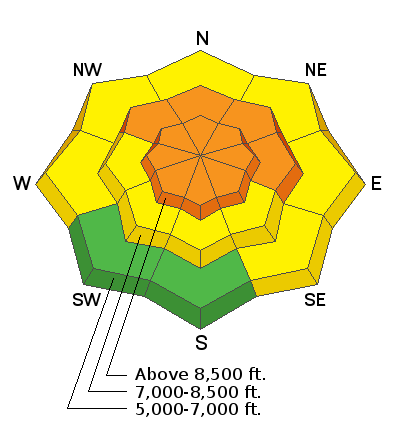
Numerous natural avalanches occurred Thursday night in the Tony Grove Area, and several "user friendly" avalanches were remote triggered by different parties in the area Friday. Most of the avalanches were remote triggered from a distance before folks committed to steep slopes, and nobody got caught. The avalanches on north and east facing slopes from about 7500' up to 9000', were mostly about 1' deep, with some about 2' deep, and 20' to 400' wide. All failed on faceted snow and running on the mid-November thermal crust, leaving 1 to 2' of very sugary snow in bed surfaces..

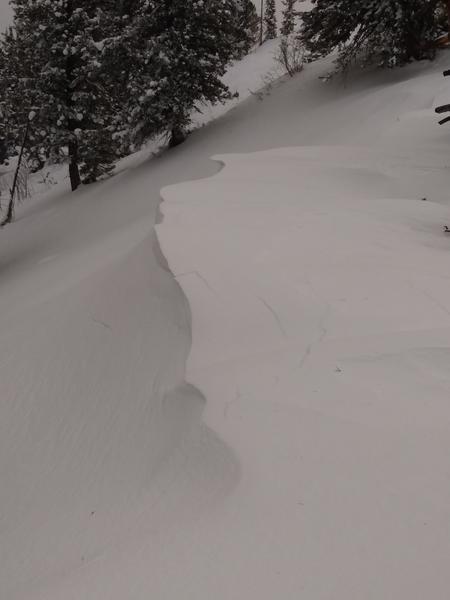
Remote triggered avalanche from Friday above Tony Grove Lake...
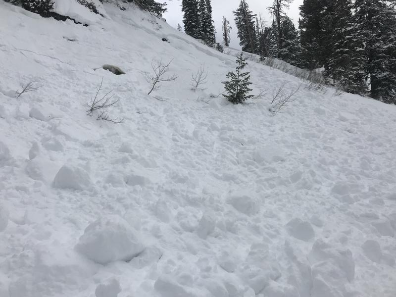
Yesterday a party triggered a small avalanche low in Garden City Bowls, down in the canyon, and nobody got caught.
Avalanche Problem #1
Persistent Weak Layer
Type

Location

Likelihood

Size

Description
Many slopes in the region are plagued by layers of weak faceted snow formed during the prolonged November dry spell.
Avalanches failing on a persistent weak layer can be very sensitive, and they might be triggered remotely, from a distance, or worse from below!
A thick layer of very weak, sugary, or faceted snow will likely be a problematic persistent weak layer on many slopes, as future snow overloads it.
Avalanche Problem #2
Wind Drifted Snow
Type

Location

Likelihood

Size

Description
Southwest and westerly winds formed stiffer drifts in lee slope avalanche starting zones and around terrain features like gullies, cliff bands, and sub ridges. Harder drifts or wind slabs are usually not as sensitive as soft ones, and they may allow people to get out on them and into avalanche paths before releasing. People are likely to trigger dangerous avalanches of wind drifted snow, 1 to 2 feet deep on steep upper and mid elevation slopes where drifts formed on weak, sugary, or faceted snow.
- Even a small avalanche could be very dangerous due to shallow early season snow conditions.
Additional Information
Everybody should make time to examine and practice with your avalanche rescue equipment, and convince your backcountry partners to practice with you. Watch our companion rescue video HERE
My tip for avoiding avalanches in the backcountry is to keep your slope angles low. Avoid and stay out from under slopes steeper than about 30 degrees. Get a tool to measure slope angle and practice with it in the backcountry. Watch the video HERE.
General Announcements
Visit this website with information about Responsible Winter Recreation by the Utah Office of Outdoor Recreation.
We've kicked off Season 4 of the UAC podcast with a Conversation with American Avalanche Institute owner Sarah Carpenter. You can stream it HERE or wherever you get your favorite podcasts.
The Tony Grove Road is not maintained for wheeled vehicles in the winter.
EMAIL ADVISORY. If you would like to get the daily advisory by email you subscribe HERE.
Remember your information can save lives. If you see anything we should know about, please help us out by submitting snow and avalanche observations....HERE. You can also call us at 801-524-5304, email by clicking HERE, or include #utavy in your tweet or Instagram.
I will update this forecast by around 7:30 tomorrow morning.
This forecast is from the USDA Forest Service, which is solely responsible for its content. The forecast describes general avalanche conditions and local variations always occur.