Get Your Ticket to the 32nd Annual Backcountry Benefit on September 11th! Support Forecasting, Awareness, and Education
Ad

Forecast: Logan Area Mountains

Forecast for the Logan Area Mountains

Toby Weed
Issued by Toby Weed on
Wednesday morning, December 11, 2019
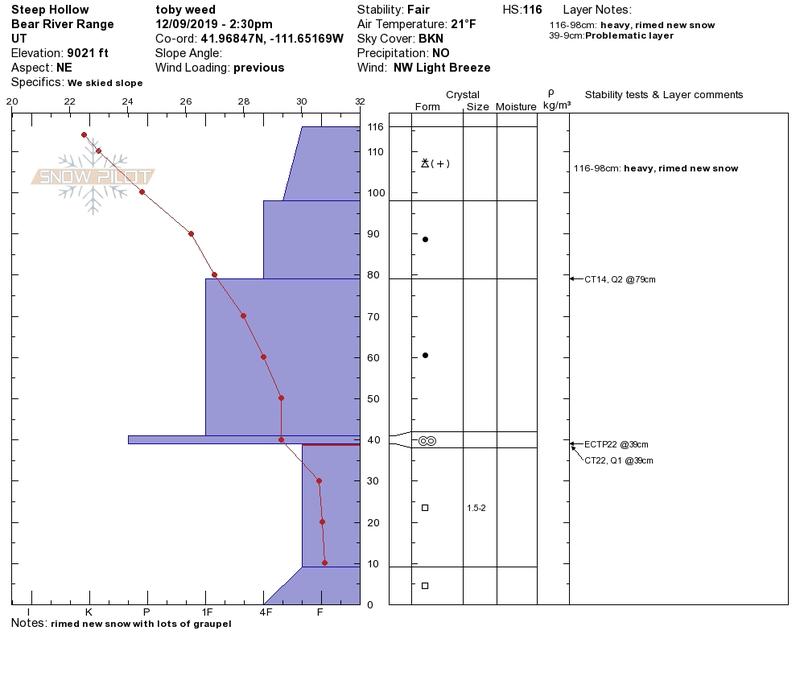
Southwest winds picked up overnight causing MODERATE danger and heightened avalanche conditions on drifted slopes in the backcountry. Also, there are still areas with more dangerous conditions on upper elevation slopes facing northwest, north, northeast, where a person could trigger a large and dangerous avalanche failing on a persistent weak layer of loose sugary snow near the ground. Safer conditions can be found at lower elevations, on lower angled or sunny slopes, and in sheltered terrain.
  • Avoid steep wind drifted slopes.
  • Evaluate snow and terrain carefully.
Low
Moderate
Considerable
High
Extreme
Learn how to read the forecast here
Weather and Snow
It's 24°F at the 8400' Tony Grove Snotel this morning, and I'm reading 32 inches of total snow containing 99% of normal SWE for the date. It's 20°F at the 9700' CSI Logan Peak weather station, and southwest winds are blowing about 28 mph. We found very nice fast powder conditions in the Logan Zone in the past couple days, even on low elevation, lower angled, and sunny slopes.
We've found very nice powder riding conditions the last couple days in rimed and graupel-filled new snow.
Snow showers are likely this afternoon, with 1 to 2 inches of accumulation possible. Expect 8500' high temperatures around 27°F, and 14 to 17 mph west-southwest winds. Snow showers are likely to continue in the evening, with about an inch of accumulation possible. It'll be mostly cloudy tonight, with low temperatures rising to around 28°F by morning, and 16 mph west-southwest winds. Snow is likely tomorrow and tomorrow night, with 6 to 14 inches of accumulation expected by Friday morning. High temperatures tomorrow will be around 29°F, and southwest wind 16 to 21 mph increasing to 23 to 28 mph in the afternoon. Winter weather is expected to continue and intensify again on Friday night, with another foot of snow possible by Saturday afternoon.
Recent Avalanches
Two riders were caught and carried, and one of them was partially buried in an avalanche just north of the Idaho State Line on Saturday afternoon. Here's the report.

On 12-3-19, a solo skier unintentionally triggered a good sized avalanche failing on the sugary persistent weak layer near the ground in the west half of Miller Bowl south of Tony Grove Lake. The avalanche on a north facing slope at around 8700' was around 2' deep and at least 150' wide. report is HERE

Ad
Avalanche Problem #1
Persistent Weak Layer
Type
Location
Likelihood
Size
Description
Most sunny slopes were bare and many others patchy or crusty after the prolonged November dry spell. But on shady slopes above about 8000' the old October snow has grown sugary and very weak. Dangerous and destructive avalanches failing near the ground are possible, and the danger on many of these slopes will persist for a while. The snow is gradually becoming more stable, but avalanches on some slopes could still be triggered remotely, from a distance, or below!
  • Cracking and collapsing are red flags indicating unstable snow conditions.

Avalanche Problem #2
Wind Drifted Snow
Type
Location
Likelihood
Size
Description
Southwest winds picked up overnight and are blowing around 30 mph on Logan Peak this morning. Soft surface snow is being drifted into lee slope deposition areas. Drifts (or wind slabs) are likely to be sensitive to human triggering again today, so as usual, avoid steep slopes with recently drifted snow.
  • Even small avalanches can be very dangerous in shallow snow conditions, because you could be dragged into rocks or stumps.
Additional Information
Thanks to the generous support of our Utah ski resorts and Ski Utah, we have discount lift tickets available. All proceeds from these go towards paying for avalanche forecasting and education! Get your tickets HERE.
Need a Christmas present for your favorite backcountry partner? Get one of these cool t-shirts to support the UAC and other avalanche centers across the U.S. HERE
General Announcements
The Tony Grove Road is not maintained for wheeled vehicles in the winter, and it is snowpacked, narrow, and icy in places. You could easily get stuck in deep snow, and it doesn't look like anyone was able to drive very far up recently. Hikers, cross country skiers, snow bikers, dogs, sleds, and 4x4s share the road this time of year, so be nice and keep your speed down around others.
It's key to head into the early avalanche season with the proper mindset. In this podcast, we talk with UAC program director Bo Torrey. Bo talks about particular risks unique to the early season, tips and tricks for knocking the rust off your early season rescue skills, and charts out the path forward with avalanche education. HERE