Check Out Our Holiday Auction!

Forecast for the Logan Area Mountains

Toby Weed
Issued by Toby Weed on
Wednesday morning, December 10, 2025

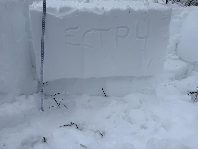
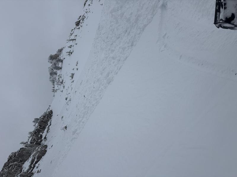
Heightened avalanche conditions exist in the backcountry, the danger is MODERATE, and people could trigger dangerous avalanches on a buried persistent weak layer buried up to 2 feet deep on slopes steeper than 30 degrees. Evaluate snow and terrain carefully, as there are some areas with CONSIDERABLE danger at upper elevations on previously drifted slopes with poor snow structure. Avalanches might be triggered remotely, from a distance, or from below.

Most slopes below 7000 feet are bare of snow or have only very shallow snow cover.
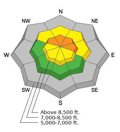
Low
Moderate
Considerable
High
Extreme
Learn how to read the forecast here
Weather and Snow

This morning, it's 35° F at the Tony Grove Snotel at 8400 feet, with 26 inches of total snow. Overnight, the station reported some precipitation, but no new snow. Winds were sustained from the west, gusting over 40 mph, but there was little drifting.

Over the weekend, the wet, warm, and windy storm dropped 2.8 inches of SWE and about a foot of dense, heavy snow on top of a weak, faceted snowpack from November. This strong-over-weak snowpack structure is responsible for many natural avalanches large enough to bury a person, as well as red flags—like whumfing and shooting cracks. Yesterday's snow stability tests in the Emigration Creek drainage showed potential for avalanches to propagate, and continued instability in some areas...

Below is a video of ECTP 4 from the Emigration Creek Drainage on December 9

NWS Forecast Discussion: Gusty winds will continue across southwest Wyoming and the higher terrain of northeast Utah today, along with a few morning showers, which could bring very light and spotty rain and very high elevation snow.
High pressure will be in place Thursday through the weekend, with dry conditions and temperatures around 10-15° F warmer than normal. Valley inversions will build as high pressure is in place.

Recent Avalanches

A rider reported triggering an avalanche on a northeast-facing slope near 9000 feet on Sunday while riding near Doubletop Mountain in Steep Hollow. The slide broke on weak, old faceted snow that was buried during this weekend's storm. His full observation is HERE.

***For all observations and avalanche activity in the Logan Zone, go HERE

Avalanche Problem #1
Persistent Weak Layer
Type
Location
Likelihood
Size
Description
Weak, rotten snow from November is buried by a slab of heavy, dense storm snow up to 2 feet deep. Where sugary snow from November existed before last weekend's storm—on north-facing slopes at mid-elevations (7500-8500 feet), and on all slopes at upper elevations —there is potential to trigger dangerous, widely propagating avalanches. In these conditions, avalanches might be triggered remotely from below or from a distance.
  • Slab avalanches failing on the buried persistent weak layer are most likely in areas where the wind has drifted snow, near ridgelines, and mid-slope catchment areas like gullies.
  • Even a small avalanche could be dangerous in these shallow snow conditions, as you might be dragged through the rocks or down trees below.
  • Follow safe travel protocols: travel with a partner, cross (or ride) steep slopes one person at a time while the rest of your party watches from a safer place.
Additional Information

For more information, visit the UAC weather page here: UAC Weather Page For Logan-specific weather, go here: Logan Mountain Weather

-For all questions on forecasts, education, Know Before You Go, events, online purchases, or fundraising, call 801-365-5522.

-Remember, the information you provide could save lives, especially if you see or trigger an avalanche. To report an avalanche or submit an observation from the backcountry, go HERE

-Receive forecast region-specific text message alerts to receive messages about changing avalanche conditions, watches, and warnings. Sign up and update your preferences HERE

This forecast is from the U.S.D.A. Forest Service, which is solely responsible for its content. This forecast describes general avalanche conditions and local variations always occur.

General Announcements
This information does not apply to developed ski areas or highways where avalanche control is normally done. This forecast is from the U.S.D.A. Forest Service, which is solely responsible for its content. This forecast describes general avalanche conditions and local variations always occur.