Forecast for the Logan Area Mountains

Toby Weed
Issued by Toby Weed for
Wednesday, November 30, 2022
Heavy snow and drifting overloaded slopes with weak sugary snow in the backcountry, and areas with CONSIDERABLE danger exist on drifted upper elevation slopes. People are likely to trigger wind slab avalanches failing on a sugary persitent weak layer if they venture into steep drifted terrain. Elevated avalanche conditions also exist in sheltered terrain and on lower and mid elevation slopes where it is quite easy to trigger small soft slab avalanches of storm snow failing on a buried persistent weak layer of feathery surface hoar.
  • Evaluate snow and terrain carefully, make cautious decisions, and avoid steep slopes with recent deposits of wind drifted storm snow.
Low
Moderate
Considerable
High
Extreme
Learn how to read the forecast here
Special Announcements
Our annual party and fundraiser is coming up on December 6 in Logan at the Cache. 19th Annual Utah Avalanche Center Pray for Snow Party and Fundraiser information and tickets HERE.
Join the Utah Avalanche Center and the Division of Outdoor Recreation to celebrate the Fourth Annual Avalanche Awareness week, from December 4 - December 11. Click HERE to view the full list of events for the week.
Weather and Snow
I'm reading 11° F on Logan Peak this morning, and increasing south-southwest wind creating a -12° F wind chill value. Today will be a nice powder day in the backcountry, although dangerous conditions exist on drifted upper elevation slopes. Southwest winds are increasing this morning and expect drifting of the nice powder in exposed terrain. Sensitive drifts or soft wind slabs built up and are getting thicker as snow is drifted onto steep upper elevation slopes plagued by widespread sugary weak snow. In exposed terrain, ridge top winds are certainly strong enough to move snow, and today they continue to build stiffer drifts out of the nice light powder.
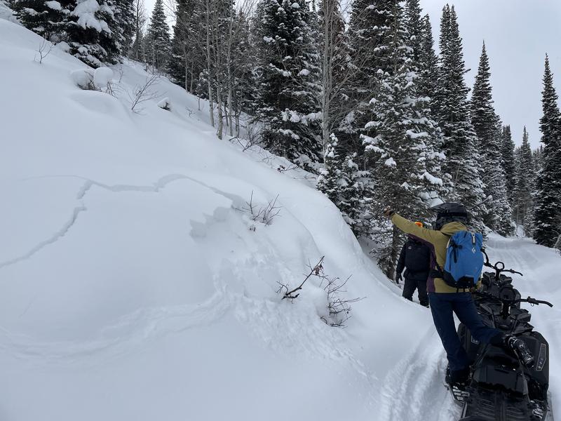
Under the fresh snow, early season snow conditions exist across the Logan Zone, with only about a foot-and-a-half to three feet of total snow covering the rocks on upper elevation slopes. There are numerous shallowly buried land mines out there.
Thankfully, it appears that active wintery weather will continue for a bit. The next in a train of winter storms is expected to impact the area on around Thursday night, with warmer temperatures, another foot+ of snow possible, and strong westerly winds... and looks like another one on the tracks for the weekend.
Recent Avalanches
See our updated list of observed avalanches from across Utah HERE
Yesterday, we couldn't see much at upper elevations due to the clouds, but we easily triggered cracking and collapsing and remote very soft slabs at mid elevations right off the Franklin Basin Road. Nikki found nice feathers of preserved surface hoar under the fresh powder and shallow Thanksgiving snow...
Ad
Avalanche Problem #1
Wind Drifted Snow
Type
Location
Likelihood
Size
Description
People could trigger 1 to 2 foot thick slab avalanches of wind drifted snow failing on a shallowly buried persistent weak layer if they venture onto exposed upper elevation slopes. It is always wise to avoid travel on steep slopes with deposits of wind drifted snow, but fresh powder may hide the obvious evidence of drifting.
  • Wind slabs often form on the lee side of exposed ridges and in and around terrain features. Watch for and avoid drifts on gully walls, under cliff bands, along sub-ridges, in scoops, saddles, and sinks.
  • Drifted snow is stiffer and more compacted than non-drifted snow.
  • Freshly formed wind slabs can be quite sensitive and are often remotely triggered.
  • Shooting cracks in drifted snow are a sure sign of instability.
Avalanche Problem #2
New Snow
Type
Location
Likelihood
Size
Description
People are likely to trigger loose avalanches of fresh or storm snow on very steep slopes. These should be generally manageable, but could cause problems if you are pushed off a cliff or into trees or other terrain traps below. Small soft slab avalanches of storm snow failing on a persistent weak layer of surface hoar are likely for people to trigger, even on sheltered and mid and lower elevation slopes steeper than 30 degrees.
The new snow fell on bare ground or very shallow snow on low and many mid elevation sunny slopes, (W, SW, S, SE) so the danger of avalanches is low, but potential might be high for hitting rocks.
Additional Information
  • Take the all-new online avalanche courses the UAC built for Know Before You Go or take other online courses listed on the KBYG website (Develop skills -> Online Learning).
  • Get your avalanche rescue gear ready for winter. Put fresh batteries in your transceiver and update the firmware. Inspect your shovel and probe. Get your airbag backpack ready by possibly doing a test deployment and update the firmware if it is an electric version.
General Announcements
Please submit your observations from the backcountry HERE.
For a list of avalanche classes from the Utah Avalanche Center go HERE
For information on where you can ride your sled or snowbike, check out this map of the winter travel plan for the Tony Grove and Franklin Basin Areas HERE.
The Tony Grove Road and other forest roads in the Logan Ranger District are not maintained for wheeled vehicles in the winter.
This information does not apply to developed ski areas or highways where avalanche control is normally done. This forecast is from the U.S.D.A. Forest Service, which is solely responsible for its content. This forecast describes general avalanche conditions and local variations always occur.