Forecast for the Logan Area Mountains

Issued by Toby Weed on
Tuesday morning, November 26, 2019
Heightened avalanche conditions exist in the backcountry on upper elevation north and northeast facing slopes. Human triggered avalanches involving new and wind drifted snow are possible today, and the danger will increase and become more widespread as winds increase this afternoon. A powerful winter storm will create increasingly dangerous avalanche conditions tomorrow through Thanksgiving Day.
- Shallow, early season conditions cause even small avalanches to be very dangerous, because you could easily be dragged into rocks or stumps/logs.
-
Avoid steep, wind drifted slopes.

Low
Moderate
Considerable
High
Extreme
Learn how to read the forecast here
Special Announcements
Join us for our 16th annual Pray for Snow Party, December 4, at The Cache in downtown Logan.
Come join us for an evening filled with good friends, good food, and good music all to support avalanche forecasting, awareness, and education. Music from The Swinging Lights!!!! Lucky Slice will be serving up gourmet slices once again.
Buy your tickets early to save $5! See you there! HERE
Weather and Snow
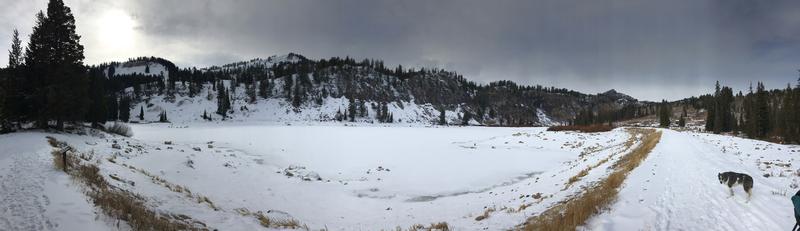
It's 11°F at the Tony Grove Lake Snotel at 8400' this morning, and I'm reading around 5 inches of new snow at the in the last 24 hrs, with 15 inches of total snow. It's 3 °F at the 9700' CSI Logan Peak weather station and northwest winds are blowing about 20 mph. Expect winds to veer from the south this afternoon and increase ahead of a strong Pacific Storm that will begin to impact the Logan Zone tonight. This looks like it'll be a productive and windy storm, with 1 to 2 feet of somewhat dense snow possible at upper elevations by Thanksgiving Day.
-The National Weather Service in Salt Lake City has issued a Winter Storm Watch for the mountains of Northern Utah for late tonight through Saturday morning.
-The NWS office in Pocatello has issued a Winter Storm Warning for the Idaho section of the Bear River Range for early tomorrow morning through early Thanksgiving Day.

- Hitting rocks and stumps is a real danger. Don't end your season before it starts with an injury from hitting one of these obstacles.
- Avalanches are a real possibility, so be prepared with rescue gear and a partner.
- The Tony Grove Road is not maintained for wheeled vehicles in the winter, and it is snowpacked, narrow, and icy in places.
- Hikers, cross country skiers, snow bikers, dogs, sleds, and 4x4s share the road this time of year, so be nice and keep your speed down around others.
Avalanche Problem #1
Wind Drifted Snow
Type

Location

Likelihood

Size

Description
Small avalanches consisting of fresh wind drifted snow are possible today on steep north facing slopes above about 8000' in elevation. Expect the danger to become more widespread as wind speeds and drifting increase this afternoon and evening.
Avalanche Problem #2
New Snow
Type

Location

Likelihood

Size

Description
Loose avalanches or sluffs and shallow soft slabs consisting of new snow are possible on slopes with preexisting weak surface snow, like this feathery surface hoar we found near Tony Grove Lake Sunday.

Additional Information
- The First Annual Avalanche Awareness Week is December 2-7 We have a week full of fun and educational events planned. Check out the schedule HERE
- As part of your early season tune-up, consider taking an avalanche class. We have lots of avalanche education classes listed already, from Know Before You Go to Companion Rescue to our Backcountry 101. Click on the Education menu on our webpage for a full list of classes from the UAC and other providers. Check out the Know Before You Go eLearning program for free, online, avalanche classes.....HERE