Forecast for the Logan Area Mountains

Toby Weed
Issued by Toby Weed for
Saturday, January 28, 2023
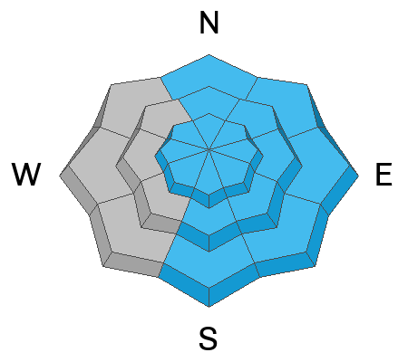
The danger is HIGH at upper and mid elevations where dangerous natural and human triggered avalanches are likely. People are likely to trigger soft slab avalanches of storm snow up to 2 feet thick as well as loose avalanches entraining significant volumes of powder snow. Long running natural avalanches are most likely during periods of particularly heavy snowfall and drifting. CONSIDERABLE danger exists at lower elevations where people are likely to trigger avalanches and natural avalanches could come from above.
  • People should avoid travel in backcountry avalanche terrain today.
  • Avoid avalanche runouts and stay off and out from under slopes steeper than about 30°
Low
Moderate
Considerable
High
Extreme
Learn how to read the forecast here
Weather and Snow
It's snowing heavily again this morning on the Beaver Mt Webcams. The Tony Grove Snotel at 8400' reports 2.4 inches of Snow Water Equivalent, in probably a couple feet of new snow from the storm so far. The temperature is 20° F, and there is around 8 feet of total snow. The CSI Logan Peak weather station at 9700' is showing winds blowing from the west-northwest this morning around 20 mph with gusts around 40 mph.
Today will be stormy, with periods of heavy snowfall and winds from the west blowing 15 to 20 mph. High temperatures at 8500' are expected to be about 18° F and 7 to 11 inches of additional accumulation is expected at upper elevations in the Northern Bear River Range.
Snow will likely continue tonight, with 8 to 12 inches of additional accumulation possible at upper elevations. Expect temperatures around 10° F, 7 to 10 mph west winds.
Tomorrow, snow showers will taper off and it'll be mostly cloudy and cold, with 3 to 5 inches of additional accumulation possible in the morning. High temperatures around 15° F and moderate winds blowing from the northwest.
It looks like the sun will be out but temperatures will stay cold (in the single digits) on Monday and Tuesday.
Recent Avalanches
A sure sign of potential instability is avalanche activity, and conditions were pretty active yesterday afternoon in the Logan Zone.
  • A few small natural avalanches of wind drifted storm snow hit the highway in the Dugway section of Logan Canyon yesterday afternoon causing a brief closure so crews could clean the soft debris off the road.
  • A skier triggered a small avalanche of wind drifted snow at 6700' in elevation on a south facing slope across from the Franklin Basin overflow parking lot.
  • Skiers report cracking and extensive drifting in lower elevation terrain adjacent to Cherry Peak
    Find a list of all observations & avalanches from across Utah HERE.
Ad
Avalanche Problem #1
New Snow
Type
Location
Likelihood
Size
Description
The National Weather Service is forecasting periods of heavy snowfall and rapid accumulations in the Bear River Range, especially in the northern part of the range, with another foot or so possibly falling during the day today and another foot possible again tonight.
  • Human triggered and natural avalanches of storm snow are likely today. Both are even more likely during periods of particularly heavy snowfall and drifting.
  • There are areas where weak surface snow was buried and preserved by light powder earlier in the week, and today's new snow will likely create potential for soft slab avalanches, especially in areas where the fresh snow is drifted onto slopes steeper than about 30°.
  • Loose avalanches entraining storm snow are likely on very steep slopes at all elevations. On sustained slopes these can pick up speed and volume pretty quickly. Generally, you should stay out from under your partners and other parties and avoid very steep terrain where you could be swept into trees, gullies or other terrain traps. But today, you should just avoid travel on and under slopes steeper than 30°.
Avalanche Problem #2
Wind Drifted Snow
Type
Location
Likelihood
Size
Description
People are likely trigger soft slabs of wind drifted storm snow up to a couple feet thick in drifted terrain. Harder wind slabs from this week will be hidden by the fresh powder, but some could still be sensitive to human triggers. Sustained winds from the west yesterday and overnight enlarged cornices and built fresh wind slabs. Some of these probably formed on weak surface snow that was preserved by a couple inches of powder on Tuesday night and could remain pretty touchy.
  • Avoid corniced slopes and stiffer drifts on steep slopes near ridges and in and around terrain features like under cliff bands, sub-ridges, mid-slope break-overs, and gully walls..
  • Even a small wind slab avalanche can have large consequences if you get swept into trees or other terrain traps.
Additional Information
From what I could see in the field Wednesday, the current storm will likely cause dangerous avalanche conditions. At least in some areas, Wednesday's super light powder buried and preserved a layer of weak surface snow. (12-25-23 photos from east facing, 8000', in Squirrel Hollow, Emigration Summit ID)
General Announcements
  • Please submit your observations from the backcountry HERE.
  • For a list of avalanche classes from the Utah Avalanche Center go HERE
  • For information on where you can ride your sled or snowbike, check out this map of the winter travel plan for the Logan and Ogden Ranger Districts HERE, and a close up of the Tony Grove and Franklin Basin Areas HERE.
This forecast is from the U.S.D.A. Forest Service, which is solely responsible for its content. This forecast describes general avalanche conditions and local variations always occur.