Forecast for the Logan Area Mountains

Toby Weed
Issued by Toby Weed for
Monday, January 21, 2019
HIGH: Avalanche danger is rising rapidly with today's storm, and people should avoid travel in avalanche terrain. Heavy snowfall and drifting is overloading slopes with buried persistent weak layers and creating very dangerous avalanche conditions in the backcountry. Natural avalanches will be most likely during periods of particularly heavy snowfall. Avalanches could be triggered remotely, from a distance, or below. Stay off and out from under steep drifted slopes.
Low
Moderate
Considerable
High
Extreme
Learn how to read the forecast here
Avalanche Warning
THE FOREST SERVICE UTAH AVALANCHE CENTER IN SALT LAKE CITY HAS CONTINUED A BACKCOUNTRY AVALANCHE WARNING.
* TIMING...THROUGH 530 AM MST TUESDAY.
* AFFECTED AREA...THE MOUNTAINS OF NORTHERN UTAH INCLUDING THE BEAR RIVER RANGE, THE WESTERN UINTA MOUNTAINS, ALL OF THE WASATCH RANGE, AND THE MANTI SKYLINE.
* AVALANCHE DANGER...STRONG WINDS AND HEAVY SNOWFALL TODAY WILL PUSH THE AVALANCHE DANGER TO HIGH.
* REASON/IMPACTS...NATURAL AND HUMAN TRIGGERED AVALANCHES ARE LIKELY. AVOID BEING ON OR UNDERNEATH SLOPES STEEPER THAN 30 DEGREES.
BACKCOUNTRY TRAVELERS SHOULD CONSULT WWW.UTAHAVALANCHECENTER.ORG OR CALL 1-888-999-4019 FOR MORE DETAILED INFORMATION.
THIS WARNING DOES NOT APPLY TO SKI AREAS WHERE AVALANCHE HAZARD REDUCTION MEASURES ARE PERFORMED.
Weather and Snow
Winds veered from the south to northwest this morning and are intensifying, drifting accumulating fresh snow into upper and mid elevation avalanche starting zones. Rapid accumulation of new snow, wind drifted snow, and widespread buried persistent weak layers are creating very dangerous avalanche conditions in the backcountry. At low elevations, the loose faceted snow near the ground was dampened by Thursday's rain, and we found unstable conditions, cooler weather solidified things a bit and increased stability, but there are many slopes with poor snow structure.
The Tony Grove Snotel at 8400' reports 4 inches of new snow early this morning, with .3" SWE. It's 27º F this morning and there's 64" of total snow containing 95% of average SWE for the date. I'm reading 20º F at the 9700' CSI Logan Peak weather station, and northwest winds are currently averaging around 20 mph and gusting to 51 mph from the south early this morning.
A potent winter storm system impact the area today and exit by midday Tuesday. A weak weather disturbances embedded in a moist northwest flow will impact mainly northern Utah and southwest Wyoming late Wednesday through Thursday ahead of a building ridge for the end of the week. Today we'll see snow, with 5 to 9 inches possible, temperatures at 8500' will drop to around 14º F, and north-northwest winds will continue to intensify, with 26 to 36 mph winds and gusts around 55 mph.
Recent Avalanches
-A backcountry skier was buried by and avalanche and killed near Fairview late Thursday. Search and rescue teams from Emery and Sanpete County recovered his body yesterday near Electric Lake on the Manti Skyline. Preliminary report HERE.
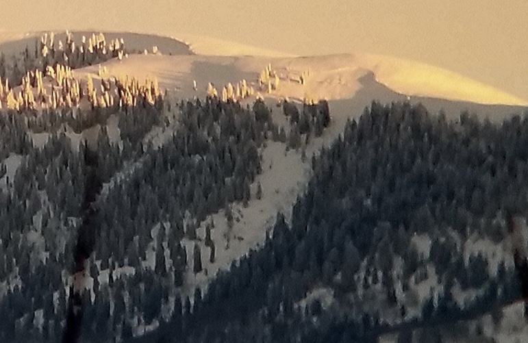
-Natural avalanches were widespread across the Logan Zone, but they're covered up by fresh snow now so not so obvious. Natural avalanches of note observed yesterday include somewhat blown-in evidence of large hard slab avalanches in Wood Camp, Tab Hollow, and Logan Dry Canyon.
Eric caught a view of this large natural avalanche in Logan Dry, just as it was hit by the last rays of sunlight.
Please report backcountry avalanche activity in the Logan Zone if you see any today....
Ad
Avalanche Problem #1
New Snow
Type
Location
Likelihood
Size
Description
Soft slab and loose avalanches involving new snow are likely on slopes steeper than about 30 degrees, even in sheltered terrain. Natural avalanches are most likely to occur during periods of particularly heavy snowfall. Storm slab avalanches could travel fast and far today.
Avalanche Problem #2
Wind Drifted Snow
Type
Location
Likelihood
Size
Description
Drifting from northwest wind continues at upper elevations this morning, and wind drifted snow is causing dangerous avalanche conditions in exposed terrain. Dangerous natural and triggered avalanches are likely. As drifts built up and continue to build on slopes with buried persistent weak layers, dangerous avalanche conditions are likely to persist for a while.
Avalanche Problem #3
Persistent Weak Layer
Type
Location
Likelihood
Size
Description
The shallow snow near the ground in many areas is loose, sugary, and faceted. Avalanches on buried persistent weak layers could be remote triggered on steep slopes with shallow snow and poor snow structure, you might trigger one from a distance, or below. The weak faceted snow will cause slopes to be unstable as they are overloaded by rapid accumulations of new snow and drifting from today's storm. A smaller new snow or wind drifted snow avalanche might step down into old snow as it descends and become large and dangerous. The sugary snow will remain weak and many slopes will probably stay unstable for a while.
Additional Information
I will update this forecast tomorrow morning.
Now is a great time to practice companion rescue techniques with your backcountry partners. You should check out and use the new Avalanche Beacon Training Park we set up at the Franklin Basin trailhead. Special thanks to Northstars Ultimate Outdoors and USU Outdoor Program for helping us to make this possible.
General Announcements
The Beaver Mountain Backside is the backcountry, and it is avalanche terrain. If you cross the ski area boundary, you and your partners should carry and practice with avalanche rescue equipment.
Check out the improved weather links, road conditions, and weather links for each forecast region on the new UAC IOS App. Do you use the NOAA point forecast? If so, now you can bookmark your favorite weather locations in "My Weather" in the App. HERE
Are you new to the backcountry or looking to refresh your skills? The UAC has released a free 5-part avalanche skills eLearning series. HERE
If you would like to get the daily advisory by email you subscribe HERE.
Support the UAC through your daily shopping. When you shop at Smith's, or online at REI, Backcountry.com, Patagonia, NRS, Amazon, eBay by clicking on these links, they donate a portion of your purchase to the UAC. If you sell on eBay, you can have your See our Affiliate Page for more details on how you can support the UAC when you shop
Remember your information can save lives. If you see anything we should know about, please help us out by submitting snow and avalanche observations. HERE You can call us at 801-524-5304, email by clicking HERE, or include #utavy in your Instagram.
This forecast is from the U.S.D.A. Forest Service, which is solely responsible for its content. The forecast describes general avalanche conditions and local variations always occur.