Get Your Ticket to the 32nd Annual Backcountry Benefit on September 11th! Support Forecasting, Awareness, and Education
Ad

Forecast: Logan Area Mountains

Forecast for the Logan Area Mountains

Toby Weed
Issued by Toby Weed on
Thursday morning, January 16, 2020
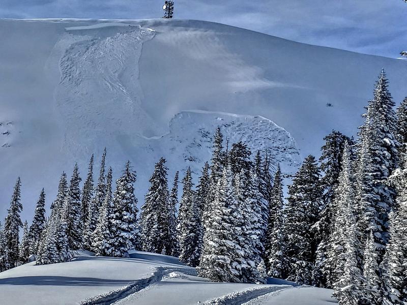
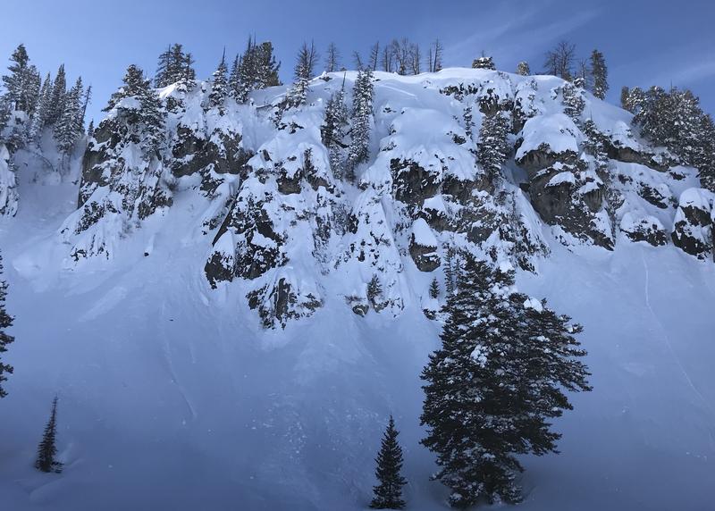
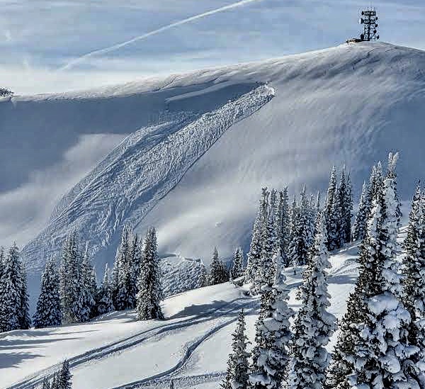
Dangerous avalanche conditions exist in the backcountry, and there's CONSIDERABLE danger on drifted upper and mid elevation slopes. People are likely to trigger avalanches of wind drifted snow, and natural avalanches are possible. Some avalanches could fail on a buried persistent weak layer and be large, fast moving and long running. Loose wet avalanches are possible on sheltered slopes with saturated surface snow.
  • Evaluate snow and terrain carefully. Use caution while route finding, and make conservative decisions.
  • Avoid travel on drifted slopes and continue to stay clear of avalanche run-out zones.
Low
Moderate
Considerable
High
Extreme
Learn how to read the forecast here
Weather and Snow
It's 19°F at the 8400' Tony Grove Snotel this morning, and there is 88 inches of total snow, with 128% of average SWE for the date. The station reports nearly 6" of Snow Water Equivalent in the last week, (since Wednesday,1-8-20). It's 24°F at the CSI weather station at 9700' on Logan Peak, and south winds are ripping snow off exposed slopes, currently blowing about 47 mph with a 67 mph gust in the last hour.
Deep powder blankets the Bear River Range. The fresh snow is so deep and soft it is keeping people off of steep upper elevation slopes and out of danger. Riders are finding plenty of challenge and fantastic powder riding in lower angled terrain. Dangerous avalanche conditions exist on drifted upper and mid-elevation slopes, with human triggered avalanches likely, and fast moving and long running natural avalanches possible.
The upper restrooms in the Tony Grove Campground on 1-15-2020, buried by feet of fresh powder and 96 inches of total snow.
Expect partly sunny skies today, with increasing clouds and wind. 8500' high temperatures will be around 33°F, south winds 13 to 18 mph this morning will increase to 23 to 28 mph by afternoon. It'll be mostly cloudy tonight, with snow and blowing snow late, and 5 to 9 inches of accumulation possible. Expect a low temperature around 16°F, with 28 to 40 mph south-southwest winds. It will be snowing and snow will be drifting tomorrow morning, with 3 to 5 inches possible, high temperature around 25°F, and 25 to 36 mph winds. Benign weather is expected for upcoming weekend as the pattern shifts, and a high pressure system builds over the area.
Recent Avalanches
Tragically, a snowmobiler was killed in an avalanche yesterday near Ketchum ID, in the Baker Creek drainage of the Smoky Mountains. Here is a link to the Sawtooth Avalanche Center's Forecast.

A large hard slab avalanche was observed yesterday morning in the Rodeo Grounds on the east side of Logan Peak. It may have been remote triggered from the ridge as sled tracks were also observed. The large avalanche failed on sugary faceted snow near the ground.

Yesterday we could see blown-in evidence of fairly extensive natural storm and wind slab activity that occurred during the storm across the zone. From a distance, I thought I could see a large crown from a natural deep slab avalanche on the east buttress of Mt. Gog on a drifted south-southeast facing slope.
This small natural avalanche of wind drifted snow above Tony Grove Lake occurred late in the storm.
On Monday, a natural avalanche on a west facing slope at about 7200' in elevation stopped just before hitting highway 89 in Beaver Canyon. A trail groomer in Bear Lake County reports remote triggering avalanches on hills he's never before seen slide before.

Friday, a rider triggered and rode out of an avalanche on a south facing slope @ 9000' in Boss Canyon, Franklin Basin near state line. The avalanche was about 15" deep x ~50' wide.
Ad
Avalanche Problem #1
Wind Drifted Snow
Type
Location
Likelihood
Size
Description
South winds increased significantly overnight, drifting the nice powder into lee slope avalanche starting zones. People are likely to trigger avalanches of wind drifted snow on many upper and mid elevation slopes. Avalanches are possible to trigger on some lower elevation slopes as well. Some avalanches could step down into buried persistent weak layers, involve large volumes of snow, and run fast and far.
  • Watch for and avoid stiffer drifted snow near ridge lines and in and around terrain features like cliff bands, scoops, gully walls, and sub-ridges.
  • Wind slabs are often rounded and chalky looking, and they might sound hollow, like a drum.
  • Avoid ridge top cornices, which can break much further back than expected and start avalanches on slopes below.
Avalanche Problem #2
Persistent Weak Layer
Type
Location
Likelihood
Size
Description
Human triggered avalanches failing on a buried persistent weak layer are likely on drifted upper and mid elevation slopes and possible at lower elevations. The cold weather Christmas week created sugary weak surface snow in many areas. Some avalanches might be triggered remotely, from a distance or below. South facing, wind scoured, rocky, and mid and lower elevation slopes with shallow snow cover are plagued by sugary, faceted snow, now deeply buried by feet of fresh powder. All the additional weight from the recent snow could be enough to reactivate a deeply buried persistent weak layer on some north and east facing slopes.
The fresh avalanche in the Rodeo Grounds appears to have failed on sugary faceted snow near the ground.
Greg found the surface hoar layer buried by the New Years Storm in Garden City Bowls
Avalanche Problem #3
Wet Snow
Type
Location
Likelihood
Size
Description
Temperatures will be above freezing for the first time in quite a while. Cloud cover and winds will keep most slopes from warming too quickly but the fresh snow on some may get damp. Loose wet avalanches are possible on sheltered sunny slopes with saturated surface snow.
Warming temperatues will also cause an increased danger of roof avalanches, so watch the kids if your metal roof has a good deal of snow on it after the recent storms.
Additional Information
Paige discusses our concerns about the drifted in east faces in upper Providence Canyon:
General Announcements
New UAC Podcast - An Avalanche Forecaster, a Meteorologist, and an Economist Walk Into a Bar..... HERE
The anual CROWBAR backcountry ski race will be on Saturday, February 8. The unique and classic backcountry race will be held at the Swan Flat/Garden City Trailhead in upper Logan Canyon. There are four divisions (Junior, Recreation, Heavy Metal & Race) with different climbs, descents, and technical booters. Participants must carry avalanche rescue gear (beacon, shovel, probe) and can use alpine touring gear, telemark skis, or splitboards. Register on UltraSignup, or sign up to volunteer at this year's race!
Thanks to the generous support of our Utah ski resorts and Ski Utah, we have discount lift tickets available. All proceeds from these go towards paying for avalanche forecasting and education! Get your tickets HERE.
EMAIL ADVISORY. If you would like to get the daily advisory by email you subscribe HERE.
Remember your information can save lives. If you see anything we should know about, please help us out by submitting snow and avalanche observations....HERE. You can also call us at 801-524-5304, email by clicking HERE, or include #utavy in your tweet or Instagram.
This forecast is from the USDA Forest Service, which is solely responsible for its content. The forecast describes general avalanche conditions and local variations always occur.
I will update this forecast before about 7:30 tomorrow morning.