Forecast for the Logan Area Mountains

Toby Weed
Issued by Toby Weed for
Wednesday, January 16, 2019
MODERATE: A couple inches of new snow in the Logan Zone will not change the avalanche danger much. Weak, sugary or faceted snow is widespread in the backcountry, but the snow is currently stable on most slopes. Pockets of heightened avalanche conditions exist on previously drifted slopes with buried persistent weak layers, and dangerous human triggered avalanches 2 to 3 feet deep remain possible on steep slopes at all elevations. Expect to find heightened conditions and rising danger of avalanches involving fresh wind drifted snow at upper elevations.
  • Evaluate snow and terrain carefully.
Low
Moderate
Considerable
High
Extreme
Learn how to read the forecast here
Special Announcements
Now is a great time to practice companion rescue techniques with your backcountry partners. You should check out and use the new Avalanche Beacon Training Park we set up at the Franklin Basin trailhead. Special thanks to Northstars Ultimate Outdoors and USU Outdoor Program for helping us to make this possible.
Weather and Snow
A couple inches of light new snow fell overnight, and southwest winds are creating shallow and perhaps sensitive drifts on upper elevation slopes. The National Weather Service has issued a Winter Storm Watch for Thursday and Friday in the Logan Zone. With widespread buried weak sugary or faceted snow and weak surface snow on many slopes now capped by a few inches of light fluffy powder, the avalanche danger is likely to rise significantly as we head into the weekend.

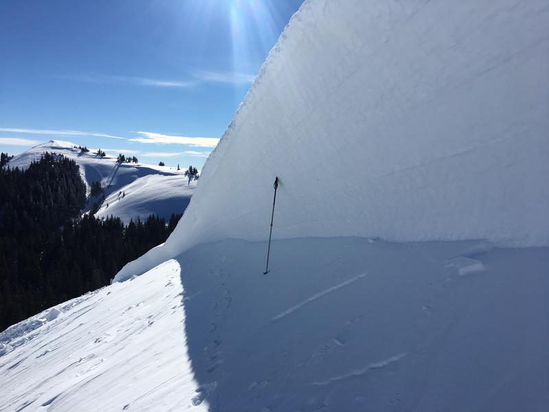
The deep crown of the Fairgrounds hard slab avalanche near Logan Peak, which occurred on Saturday Morning.
The Tony Grove Snotel at 8400' reports a couple inches of new snow overnight. It's 27º F and there's 46" of total snow containing 81% of average SWE. I'm reading 20º F at the 9700' CSI Logan Peak weather station, and southwest winds are currently averaging around 25 mph.
A series of weather systems will impact the area through Wednesday, with a more potent system expected Thursday through Friday. Expect snow in the mountains today with 2 to 4 inches of accumulation possible. A high temperature of 28º F at 8500' and 10 to 20 mph southwest winds are expected. Tonight will be mostly cloudy with a chance of snow showers. Low temperatures around 21º F and 13 to 17 mph south-southwest wind expected. Tomorrow, 4 to 8 inches of snow possible, high temperatures around 34º F , and 15 to 20 mph south-southwest wind.
Recent Avalanches
A large avalanche occurred Saturday morning (1/12/19) on the east side of Logan Peak in the Fairgrounds Bowl. It was probably remote triggered by riders in the area. See report HERE
Thanks to Ryan Thompson for the photography

That brings the number of unintentionally human triggered avalanches in the Logan Zone that we know of up to 6 in 2019. (all since 1/4/19) The list of recent avalanches in the Logan Zone list is HERE
Ad
Avalanche Problem #1
Persistent Weak Layer
Type
Location
Likelihood
Size
Description
Last week, deep drifts built up on sugary or faceted persistent weak layers, and heightened avalanche conditions exist at all elevations. The shallow snow on the ground in many areas became loose, sugary, and faceted during the New Years cold spell. Slabs of harder snow formed on top of the loose faceted snow during the windy storm last weekend, and if you trigger an avalanche today it might step down into old snow and be large and dangerous. Avalanches could be directly triggered on very steep slopes with shallow snow and poor snow structure, but you might trigger one remotely, from a distance, or below. The buried sugary snow on many slopes will remain weak for a while.

Here is some December snow, (now well developed facets) I found buried on the west side of Beaver Mountain. The weak sugary snow is stable on most slopes for now, but could easily become unstable again with loading from tomorrow's rather warm and moist looking storm.
Avalanche Problem #2
Wind Drifted Snow
Type
Location
Likelihood
Size
Description
Wind drifted snow will create heightened avalanche conditions on upper elevation slopes, and you might trigger shallow wind slab avalanches involving fresh snow. The danger will increase further tomorrow as a winter storm impacts the Logan Zone.
Additional Information
I will update this forecast by Friday morning.
General Announcements
The Beaver Mountain Backside is the backcountry, and it is avalanche terrain. If you cross the ski area boundary, you and your partners should carry and practice with avalanche rescue equipment.
Check out the improved weather links, road conditions, and weather links for each forecast region on the new UAC IOS App. Do you use the NOAA point forecast? If so, now you can bookmark your favorite weather locations in "My Weather" in the App. HERE
Are you new to the backcountry or looking to refresh your skills? The UAC has released a free 5-part avalanche skills eLearning series. HERE
If you would like to get the daily advisory by email you subscribe HERE.
Support the UAC through your daily shopping. When you shop at Smith's, or online at REI, Backcountry.com, Patagonia, NRS, Amazon, eBay by clicking on these links, they donate a portion of your purchase to the UAC. If you sell on eBay, you can have your See our Affiliate Page for more details on how you can support the UAC when you shop
Remember your information can save lives. If you see anything we should know about, please help us out by submitting snow and avalanche observations. HERE You can call us at 801-524-5304, email by clicking HERE, or include #utavy in your Instagram.
This forecast is from the U.S.D.A. Forest Service, which is solely responsible for its content. The forecast describes general avalanche conditions and local variations always occur.