Forecast for the Logan Area Mountains

Issued by Toby Weed on
Tuesday morning, January 14, 2020
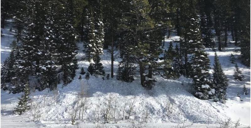
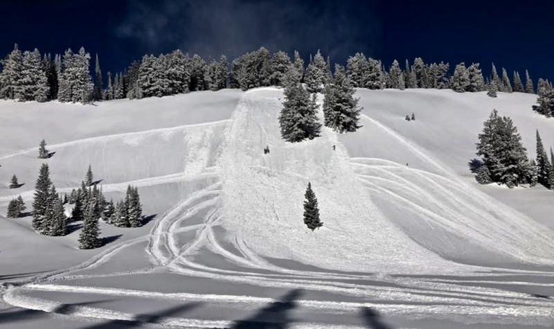
Heavy snow and drifting from strong southwest winds will cause rising avalanche danger during the day. A HIGH avalanche danger exists on drifted upper and mid elevation slopes. Large, fast moving, and long running natural avalanches are possible, and people are likely to trigger avalanches of wind drifted snow. Loose and soft slab avalanches of new snow are likely on many steep slopes and possible at all elevations.
- Stay off and out from under steep wind drifted slopes.
- Avoid travel in avalanche terrain and stay clear of avalanche run-out zones.

Low
Moderate
Considerable
High
Extreme
Learn how to read the forecast here
Avalanche Warning
IN EFFECT FROM 6 AM MST THIS MORNING TO 6 AM MST WEDNESDAY
FOR THE BEAR RIVER RANGE IN SOUTHEAST IDAHO.
THE AVALANCHE DANGER FOR THE WARNING AREA IS HIGH, WITH VERY DANGEROUS AVALANCHE CONDITIONS ON DRIFTED UPPER ELEVATION SLOPES
HEAVY SNOW AND DRIFTING FROM STRONG WEST WINDS HAVE CREATED AREAS OF UNSTABLE SNOW ON UPPER ELEVATION SLOPES.
BOTH HUMAN TRIGGERED AND NATURAL AVALANCHES ARE LIKELY. AVOID TRAVEL IN AVALANCHE TERRAIN. STAY OFF OF AND OUT FROM UNDER SLOPES STEEPER THAN 30 DEGREES.
Weather and Snow
It's 23°F at the 8400' Tony Grove Snotel this morning, and there is another 10 inches of new snow with 1.0" Snow Water Equivalent from yesterday and overnight. There is 86 inches of total snow, with 124% of average SWE for the date. The station reports 4.4" SWE since Wednesday (1-8-20). It's 14°F at the CSI weather station at 9700' on Logan Peak, and southwest winds are currently blowing about 30 mph, with a 63 mph gust earlier this morning
Very dangerous avalanche conditions exist on drifted upper and mid-elevation slopes. Heavy snowfall and strong southwest winds will create HIGH avalanche danger, especially in the northern part of the Logan Zone, with human triggered and fast moving and long running natural avalanches likely.
It is snowing heavily in the mountains today, with 10 to 16 inches of accumulation possible. 8500' high temperatures will be around 25°F, southwest winds 26 to 32 mph, and wind chill values will be around -7°F. Snow showers will continue tonight, with 3 to 5 inches of accumulation possible. Low temperatures are expected to be about 7°F, with strong, 22 to 30 mph west-southwest winds, and wind chills around -15°F. Looks like a bit of a break tomorrow, with partly sunny skies, high temperatures around 24°F, west winds 11 to 16 mph, veering from the south in the afternoon. Another potent storm is expected to impact the area late Thursday into Friday.
Recent Avalanches
Yesterday, natural avalanches of new and drifted snow occurred at all elevations. A natural avalanche on a west facing slope at about 7200' in elevation stopped just before hitting highway 89 in Beaver Canyon. A trail groomer in Bear Lake County reports remote triggering avalanches on hills he's never before seen slide before.

A natural avalanche started in the forest and stopped just above highway 89 in Beaver Canyon. 1-13-2020.
Friday, a rider triggered and rode out of an avalanche on a south facing slope @ 9000' in Boss Canyon, Franklin Basin near state line. The avalanche was about 15" deep x ~50' wide.

A rider triggered a 2' deep and 100' wide avalanche on an east facing slope at around 8200' in elevation near White Pine Creek on Tuesday, 1-7-2020. No one was caught or injured.
Avalanche Problem #1
Wind Drifted Snow
Type

Location

Likelihood

Size

Description
Natural avalanches of wind drifted snow are likely during today's storm, so you'll want to avoid travel in avalanche terrain and stay clear of run-out zones. People are likely to trigger 2 to 4 foot deep avalanches of wind drifted snow on upper and some mid elevation slopes. Avalanches are possible on many other mid elevation and some lower elevation slopes as well.
- Watch for and avoid stiffer drifted snow near ridge lines and in and around terrain features like cliff bands, scoops, gully walls, and sub-ridges.
- Wind slabs are often rounded and chalky looking, and they might sound hollow, like a drum.
- Soft fresh wind slabs can be quite sensitive, and are often remotely triggered. Hard wind slabs can be more devious, sometime allowing one to get out on them before releasing.
- Avoid ridge top cornices, which can break much further back than expected and start avalanches on slopes below.
Avalanche Problem #2
Persistent Weak Layer
Type

Location

Likelihood

Size

Description
Human triggered avalanches failing on a buried persistent weak layer are likely on drifted upper and mid elevation slopes and possible at lower elevations. The cold weather Christmas week created sugary weak surface snow in many areas. Some avalanches might be triggered remotely, from a distance or below.
Friday's sled triggered avalanche in Boss Canyon was on a south facing slope at around 9000' in elevation, and we triggered a collapse on a south facing slope on White Pine Knob at about 8900'. These rad flags lead us to suspect particular instability on upper elevation south facing slopes.
Avalanche Problem #3
New Snow
Type

Location

Likelihood

Size

Description
Natural and human triggered loose powder sluffs and shallow soft slabs of drifted new snow are likely on steep slopes at all elevations. Avalanches of powder snow can move fast and run far. Even small avalanches can be quite dangerous if you get dragged into trees or other terrain traps below.
Additional Information
Paige discusses our concerns about the drifted in east faces in upper Providence Canyon:
General Announcements
New UAC Podcast - An Avalanche Forecaster, a Meteorologist, and an Economist Walk Into a Bar..... HERE
The anual CROWBAR backcountry ski race will be on Saturday, February 8. The unique and classic backcountry race will be held at the Swan Flat/Garden City Trailhead in upper Logan Canyon. There are four divisions (Junior, Recreation, Heavy Metal & Race) with different climbs, descents, and technical booters. Participants must carry avalanche rescue gear (beacon, shovel, probe) and can use alpine touring gear, telemark skis, or splitboards. Register on UltraSignup, or sign up to volunteer at this year's race!
Thanks to the generous support of our Utah ski resorts and Ski Utah, we have discount lift tickets available. All proceeds from these go towards paying for avalanche forecasting and education! Get your tickets HERE.
EMAIL ADVISORY. If you would like to get the daily advisory by email you subscribe HERE.
Remember your information can save lives. If you see anything we should know about, please help us out by submitting snow and avalanche observations....HERE. You can also call us at 801-524-5304, email by clicking HERE, or include #utavy in your tweet or Instagram.
This forecast is from the USDA Forest Service, which is solely responsible for its content. The forecast describes general avalanche conditions and local variations always occur.
I will update this forecast before about 7:30 tomorrow morning.