Check Out Our Holiday Auction!

Forecast for the Logan Area Mountains

Toby Weed
Issued by Toby Weed on
Sunday morning, December 7, 2025

There is CONSIDERABLE avalanche danger on drifted upper-elevation slopes. People are likely to trigger dangerous slab avalanches up to 2 feet deep on slopes steeper than about 30 degrees.

  • Careful snowpack evaluation, cautious route finding, and conservative decision making are essential in upper-elevation terrain today.
  • Avoid travel in drifted terrain.
  • Low elevation slopes were mostly bare of snow last week.
Low
Moderate
Considerable
High
Extreme
Learn how to read the forecast here
Weather and Snow

This morning, the Tony Grove Snotel at 8400' reports 23° F, with 28 inches of total snow. Overnight winds remained sustained, blowing from the west-northwest 25 to 40 mph on Logan Peak. On Paris Peak, it's blowing from the same direction, 15 to 22 mph currently, with overnight gusts around 40 mph. Temperatures range from 16° F on Paris Peak to 31° F down in Logan.

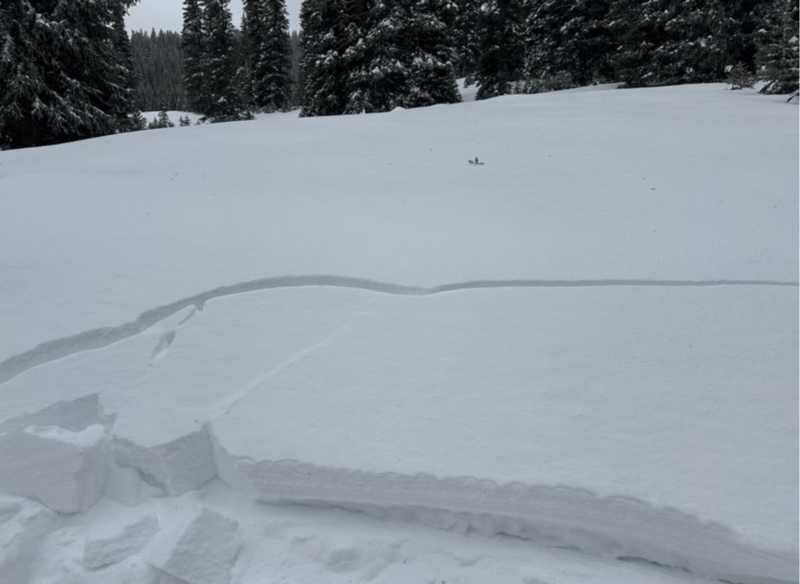
Friday night's windy storm made the upper parts of the Tony Grove Road virtually impassable in wheeled vehicles, and you are likely to get stuck if you try to drive up to the lake. Riders report numerous trees down, deep drifts, wind-blasted terrain, with around a foot of heavy new snow in the Tony Grove Area. The riders observed plenty of natural avalanche activity that occurred during the storm and Red Flags of Instability, including shooting cracks and whoompfing.

Friday, we were disappointed by a nasty rime event that created a horrible, breakable crust in open terrain on top of very weak sugary snow from earlier in the week and November. At least Friday night's heavy snow has buried it, but the now-buried rime crust will likely complicate things in the future.

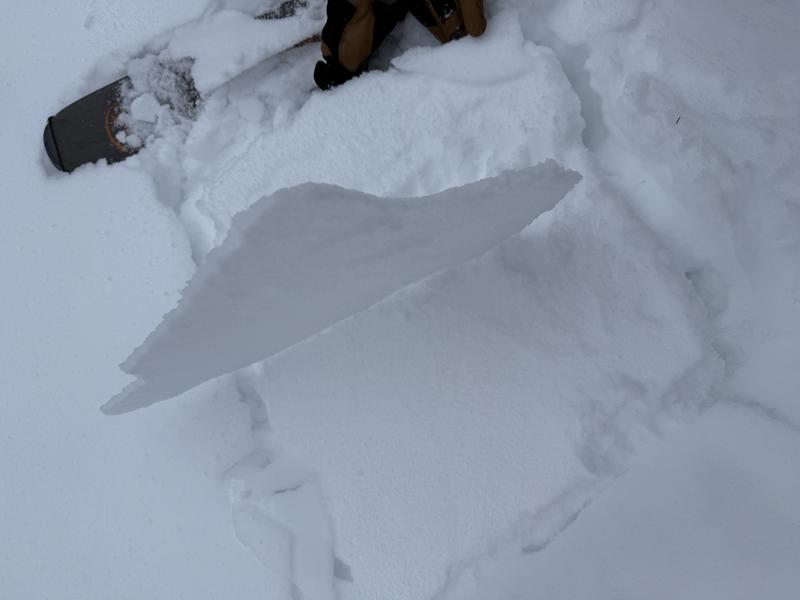
*This from this morning's NWS forecast discussion: "Generally tranquil conditions are expected over Utah and southwest Wyoming through Monday, with just a few showers late Sunday into Monday morning near the Utah/Idaho border. Winds will increase Tuesday into Wednesday, bringing the potential of strong winds to southwest Wyoming and the western Uinta Basin. There is 25% chance that the northern Utah mountains will see warm atmospheric river moisture return by midweek, with a 75% chance that windy conditions will persist with minimal moisture. "

In the Logan Zone: Snow showers and a few inches of accumulation are possible in upper-elevation terrain today and tomorrow, and are increasingly likely as we head into the week.

Recent Avalanches

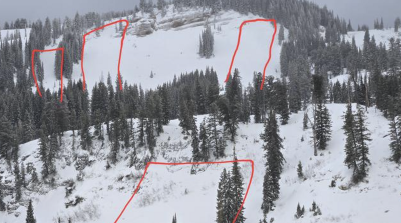
Riders who made it up to Tony Grove Lake yesterday observed that a fairly widespread natural avalanche cycle had occurred overnight. Blown in evidence of slab avalanches failing on sugary faceted snow, 1 ot 2 feet deep could be seen on numerous north and northeast-facing slopes above the south side of the lake. ***For observations and avalanche activity in the Logan Zone, go HERE

Avalanche Problem #1
Wind Drifted Snow
Type
Location
Likelihood
Size
Description
Dangerous conditions exist in upper elevation terrain today, and people should avoid travel in avalanche terrain. Stay off and out from under drifted slopes steeper than 30 degrees... Avalanches of wind-drifted snow failing on a now buried persistent weak layer are likely at upper elevations and possible in some exposed mid-elevation terrain.
  • Even a small avalanche could be quite dangerous in these shallow snow conditions, because you might be dragged through the rocks or down trees below.
  • We recommend people avoid upper elevation avalanche terrain today, but if you venture out, follow safe travel protocols; travel in the backcountry with companions, but cross (or ride) steep slopes one person at a time while the rest of your party watches from a safer place.
  • See video of early-season snow conditions.
Avalanche Problem #2
Persistent Weak Layer
Type
Location
Likelihood
Size
Description
Very weak, faceted snow is now buried by about a foot of heavy new snow. Avalanches might be triggered remotely, from below, or from a distance.
In many open areas, a rime-crust formed on Friday, capping the sugary November snow. This crust of differing thicknesses will complicate the snowpack situation across the zone.
Additional Information

For more information, visit the UAC weather page here: UAC Weather Page For Logan-specific weather, go here: Logan Mountain Weather

-For all questions on forecasts, education, Know Before You Go, events, online purchases, or fundraising, call 801-365-5522.

-Remember, the information you provide could save lives, especially if you see or trigger an avalanche. To report an avalanche or submit an observation from the backcountry, go HERE

-Receive forecast region-specific text message alerts to receive messages about changing avalanche conditions, watches, and warnings. Sign up and update your preferences HERE

This forecast is from the U.S.D.A. Forest Service, which is solely responsible for its content. This forecast describes general avalanche conditions and local variations always occur.

General Announcements
This information does not apply to developed ski areas or highways where avalanche control is normally done. This forecast is from the U.S.D.A. Forest Service, which is solely responsible for its content. This forecast describes general avalanche conditions and local variations always occur.