Check Out Our Holiday Auction!

Forecast for the Logan Area Mountains

Brooke Maushund
Issued by Brooke Maushund on
Monday morning, December 8, 2025

Avalanche danger is CONSIDERABLE on upper-elevation slopes where the wind has drifted snow. People are likely to trigger a large slab avalanche more than 2 feet deep—plenty big enough to bury you—on slopes steeper than about 30 degrees. You could trigger avalanches on wind-exposed mid-elevation slopes as well. Careful route-finding and avoiding travel in steep wind-affected terrain are crucial today.

Note that low elevation slopes were mostly bare of snow last week.

Low
Moderate
Considerable
High
Extreme
Learn how to read the forecast here
Weather and Snow

This morning, it's 24° F at the Tony Grove Snotel at 8400 feet, with 27 inches of snow that's continuing to settle after this weekend's storm. Overnight, moderate winds were sustained, shifting from the northwest to southwest while gusting into the 40s mph. Overnight mountain lows hit 18°F on Paris Peak, and highs reached just above freezing at 33°F on Logan Summit.

Over the weekend, the wet, warm, and windy storm that peaked from Friday night into Saturday morning dropped 2.8 inches of water and about a foot of dense, heavy snow on top of an already weak, faceted snowpack from our snowfalls October through November. This strong slab of storm snow sitting on top of the weak old snowpack structure is responsible for many natural avalanches that were large enough to bury a person, as well as too many other red flags—like whumfing and shooting cracks—to count since Friday. For more info on those avalanches, head to the natural activity section below.

Looking ahead, Northern Utah stays under northwesterly flow. There's a shortwave trough that's passing through NE Wyoming tomorrow, which will largely miss us. However, it will bring increasing winds from the NW, as well as the potential for some moisture to hit the Logan zone. While it's not going to be as significant as last weekend's storm, there's a possibility of up to 0.5 inches of water to fall in the Bear River Range by Wednesday evening. Snow levels will remain high as the temperatures gradually warm throughout the week, so don't count on any large accumulations of snow.

Recent Avalanches

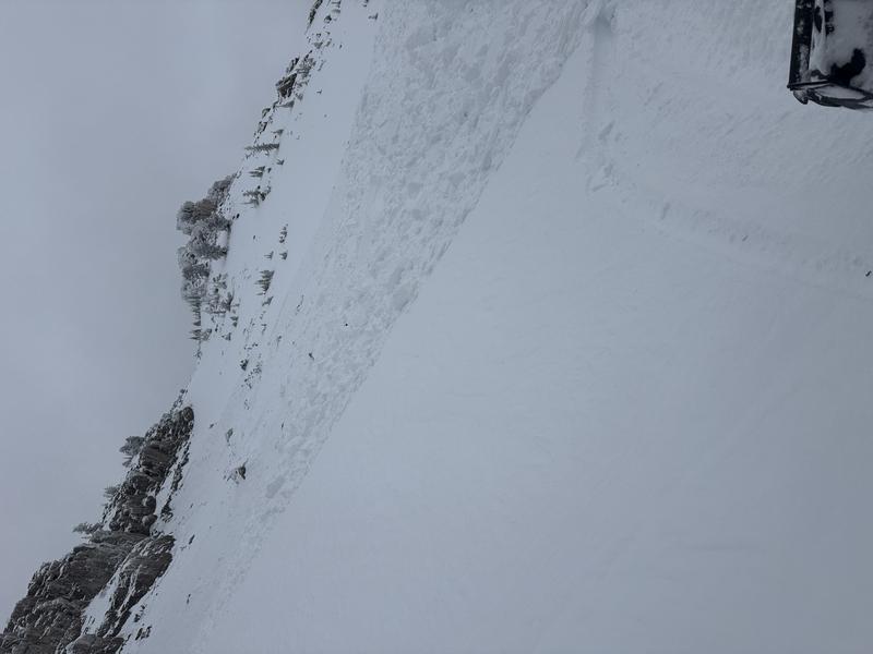
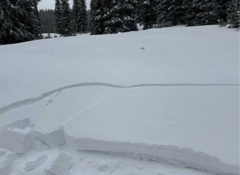
A rider reported triggering a 6 foot deep avalanche on a NE-facing slope near 8800 feet yesterday while riding near Double Top Mountain. The slide broke on weak, old faceted snow that was buried during this weekend's storm. We think it was the debris that piled up deeply. In the photo, the avalanche slab looks to be around 2 feet deep. His full observation is HERE.

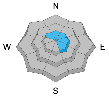
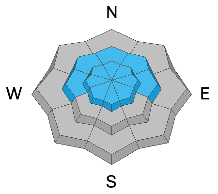
-Pro observers Katz and Applegarth spotted a number of large natural slides that likely ran during the height of the storm Friday into Saturday while traveling in the Tony Grove Lake area yesterday. The avalanches broke wide and far on the buried persistent weak layer above 8800 feet on northwest through east-facing slopes. You can find more of their obs HERE and HERE. Toby and I observed additional slides in sheltered terrain on similar aspects at mid-elevations that were also large enough to bury a person, see our ob HERE.

***For all observations and avalanche activity in the Logan Zone, go HERE

Avalanche Problem #1
Wind Drifted Snow
Type
Location
Likelihood
Size
Description
Upper elevation slopes facing northwest through southeast continue to be dangerous today. Staying off of and out from under slopes steeper than 30 degrees is the best way to stay safe today. The wind event two nights ago deposited additional snow on top of the persistent weak layer, which can make some of these slides deeper than 2 feet—and a rider triggered a 6 foot deep slide on the weak layer in wind-loaded terrain yesterday.
  • Avalanches of wind drifted snow failing on a buried persistent weak layer are also possible at mid-elevations (7500-8500 feet) in wind-exposed areas, like the natural slides Toby and I found in the Tony Grove area yesterday that were large enough to bury a person.
  • Even a small avalanche could be quite dangerous in these shallow snow conditions, because you might be dragged through the rocks or down trees below.
  • Follow safe travel protocols: travel in the backcountry with companions, cross (or ride) steep slopes one person at a time while the rest of your party watches from a safer place.
Avalanche Problem #2
Persistent Weak Layer
Type
Location
Likelihood
Size
Description
Weak, rotten snow from October through the beginning of December is now buried by about a slab of heavy, dense storm snow about a foot deep. In the places where this old snow existed before the storm—on northerly facing slopes at mid-elevations, and on all aspects at upper elevations—there is potential to trigger widely propagating avalanches large enough to bury a person. Avalanches might be triggered remotely, from below, or from a distance.
In many open areas, a rime-crust formed on Friday, capping the sugary November snow. This crust of differing thicknesses may complicate the snowpack situation across the zone as we continue to load the snowpack.
Additional Information

For more information, visit the UAC weather page here: UAC Weather Page For Logan-specific weather, go here: Logan Mountain Weather

-For all questions on forecasts, education, Know Before You Go, events, online purchases, or fundraising, call 801-365-5522.

-Remember, the information you provide could save lives, especially if you see or trigger an avalanche. To report an avalanche or submit an observation from the backcountry, go HERE

-Receive forecast region-specific text message alerts to receive messages about changing avalanche conditions, watches, and warnings. Sign up and update your preferences HERE

This forecast is from the U.S.D.A. Forest Service, which is solely responsible for its content. This forecast describes general avalanche conditions and local variations always occur.

General Announcements
This information does not apply to developed ski areas or highways where avalanche control is normally done. This forecast is from the U.S.D.A. Forest Service, which is solely responsible for its content. This forecast describes general avalanche conditions and local variations always occur.