UDOT PLANNED AVALANCHE CLOSURES!!

Forecast for the Abajos Area Mountains

Eric Trenbeath
Issued by Eric Trenbeath for
Saturday, April 2, 2022
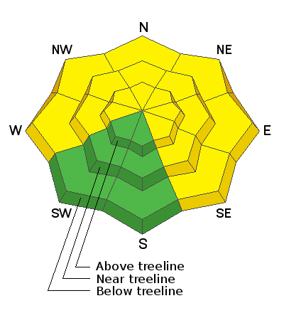
A MODERATE avalanche danger remains on steep slopes facing W-N-SE, where wet snow avalanches, and human triggered avalanches failing on a buried persistent weak layer remain possible. As the day heats up avoid being on or under steep slopes if they become wet and sloppy.
Low
Moderate
Considerable
High
Extreme
Learn how to read the forecast here
Special Announcements
Please help support avalanche forecasting throughout Utah. Donate to the Spring Campaign to help raise the funds to support the forecasting you rely on.
Weather and Snow
A few clouds are out this morning, temperatures are well below freezing, and SW winds are ramping up. Today, look for mostly sunny skies, breezy SW winds, and high temps up in the mid 40's. Clouds will develop tonight ahead of a weak system tracking to the north. Sunday will be mostly cloudy and breezy with a very slight chance for snow Sunday night. Dry conditions are on tap for the up coming week.
Snow totals and temps at Buckboard SNOTEL (8924')
Snow totals and temps at Camp Jackson SNOTEL (8858')
General Announcements
Who's up for some free avalanche training? Get a refresher, become better prepared for an upcoming avalanche class, or just boost your skills. Go to https://learn.kbyg.org/ and scroll down to Step 2 for a series of interactive online avalanche courses produced by the UAC.
This forecast is from the U.S. Forest Service, which is solely responsible for its content. This forecast describes general avalanche conditions and local variations always occur.