Donate to the 2024 Spring Campaign to help rebuild the UAC website.

Forecast for the Abajos Area Mountains

Eric Trenbeath
Issued by Eric Trenbeath for
Thursday, March 31, 2022
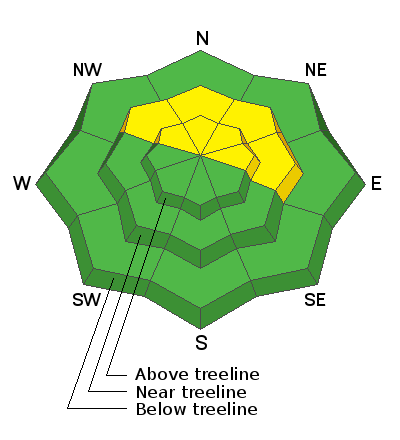
An isolated or MODERATE avalanche danger remains on steep slopes facing NW-N-NE-E, where human triggered avalanches failing on a buried persistent weak layer remain possible. This is a low probability, high consequence scenario. Don't take leaps of faith and avoid steep convexities and blind break-overs. Practice safe travel techniques and only expose one person to danger at a time.
Low
Moderate
Considerable
High
Extreme
Learn how to read the forecast here
Special Announcements
Please help support avalanche forecasting throughout Utah. Donate to the Spring Campaign to help raise the funds to support the forecasting you rely on.
Weather and Snow
Today we'll see cloudy skies and light WSW winds as a mid level trough approaches from the west. A chance for light snow will develop this evening with an inch or two possible tonight. Friday and Saturday we'll see clear skies and warm temperatures. Clouds develop on Sunday ahead of a zonal system that currently looks to be tracking to the north.
Snowpack
Four inches of new snow came in warm and moist on Tuesday, and is well bonded to the old surface.We still have some concern for the buried persistent weak layer of facets that exists on slopes that face NW-N-NE-E. It is still possible to trigger an avalanche 2-3 deep on this weak layer. Most south facing terrain is bare ground.
Snow totals and temps at Buckboard SNOTEL (8924')
Snow totals and temps at Camp Jackson SNOTEL (8858')
Recent Avalanches
There are no recent reports of avalanches from the Abajo range.
Avalanche Problem #1
Persistent Weak Layer
Type
Location
Likelihood
Size
Description
A persistent weak layer of faceted snow still exists near treeline and above on NW-N-NE-E aspects beneath a slab that is 2'-3' thick. Time and recent warm temperatures have helped this layer to gain strength. Yesterday I found a strong, stiff slab overlying the weak layer. The buried weak layer did not react to stability testing yesterday, but we're not entirely out of the woods yet. The weekend heat wave was an unusual and significant event and I'd like to see a few more snowpits that show strong snow and no failures. For now, you should expect some lingering instabilities involving this buried persistent weak layer. I am most suspect of sparsely treed areas right around treeline. Other spots where you could possibly trigger this layer include shallow snowpack areas, near rock outcroppings, and gully walls.
General Announcements
Who's up for some free avalanche training? Get a refresher, become better prepared for an upcoming avalanche class, or just boost your skills. Go to https://learn.kbyg.org/ and scroll down to Step 2 for a series of interactive online avalanche courses produced by the UAC.
This forecast is from the U.S. Forest Service, which is solely responsible for its content. This forecast describes general avalanche conditions and local variations always occur.